
| Home | Information Sharing & Analysis | Prevention & Protection | Preparedness & Response | Research | Commerce & Trade | Travel Security & Procedures | Immigration |
| About the Department | Open for Business | Press Room |

The threat level in the airline sector is High or Orange. Read more.

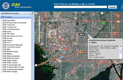
The iCAV application is a secure, Web-based, geospatial visualization tool that integrates commercial and government-owned data and imagery from multiple sources. Using iCAV, homeland security partners can establish a comprehensive situational and strategic awareness across the nation and around the globe to better prepare, prevent, respond and recover from natural and man-made disasters.
With the iCAV application, users are able to selectively view and analyze infrastructure data in an electronic map to better understand the potential impact of a disaster on communities, as well as display the nearest response resources, such as hospitals, police and fire stations and evacuation routes.
iCAV can be used to deliver a managed User-Defined Operating Picture (UDOP) across all levels of government in support of incident management, infrastructure protection and threat-mapping activities.
Federal, state and local homeland security mission partners may access iCAV 24/7/365 from any Web-enabled computer with a Homeland Security Information Network (HSIN) username and password.
For more information, please e-mail the iCAV Project Team at iCAV.info@dhs.gov.
This page was last reviewed/modified on August 1, 2008.