

 Products
USGS to Host Congressional Briefing on Climate Change and Invasive Species
Reporters: Want to accompany USGS scientists as they install storm surge sensors? Contact Leroy Pearman at 321-354-5248 or lpearman@usgs.gov.
US Geological Survey (USGS) scientists will be installing storm-surge sensors to prepare for Hurricane Ike.
These temporary devices are installed just hours before an impending storm and provide additional monitoring data in critical areas needed for effective forecasting and emergency response.
"We could not accurately forecast river flows and water-levels without the data and support we receive from the USGS," said Dave Reed, Hydrologist-In-Charge of the National Weather Service Lower Mississippi River Forecast Center in Slidell, LA. "When river and tide data are not available, our job of forecasting is much more difficult and typically results in diminished accuracy of those forecasts."
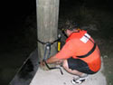 |
| USGS scientists will be installing storm surge sensors to prepare for Hurricane Ike. |
A special interactive USGS Water Hazards Map will be available soon, which will provide real-time flooding and storm surge data from streamgages and temporary devices. This information is imperative to local, State and Federal officials in order to forecast floods and coordinate flood-response activities in the affected area. Track streamflow and water levels and access other USGS Hurricane Ike efforts by visiting http://www.usgs.gov/ike.
Access real-time data from over 7,500 streamgages across the country by visiting the USGS Water Watch Website at http://water.usgs.gov/waterwatch/.
USGS has a network of rugged, inexpensive water-level and barometric-pressure sensors, called storm-surge sensors, which will be installed right before Ike hits land. These sensors provide information about storm surge duration, times of surge arrival and retreat, and maximum depths, which is useful in forecasting and modeling future events. Tropical Storms Katrina and Rita vividly demonstrated that coastal storm surge can be as dangerous as inland flooding caused by rain.
For more than 125 years, the USGS has monitored flow in selected streams and rivers across the United States and does so in cooperation with over 850 federal, state and local agencies.
Contacts:
If you would like to know more specific information about USGS Hurricane Ike response activities in your area, please contact the appropriate person listed below.
- Alabama: Athena Clark, 334-395-4141, athclark@usgs.gov
- Florida: Barry Rosen, 407-803-5508, brosen@usgs.gov
- Georgia: Ed Martin, 770-903-9166, ehmartin@usgs.gov
- Louisiana: Charles Demas, 225-298-5481 Ext. 3117, crdemas@usgs.gov
- Mississippi: Michael Plunkett, 601-933-2940, plunkett@usgs.gov
- South Carolina, Eric Strom, 803-750-6109, ewstrom@usgs.gov
- Texas: Robert Joseph, 512-927-3500, rljoseph@usgs.gov
National Flood Specialist: Robert Holmes, 573-308-3581, bholmes@usgs.gov
