Grand Coulee DamLaser Light Show | Employment | Photo Gallery | History | Dataweb Statistics |
|
Introduction |
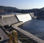
Construction of Grand Coulee Dam began in 1933 and was completed in 1942. Grand Coulee Dam is the largest hydroelectric facility in North America. It is also part of the Columbia Basin Project, irrigating more than 600,000 acres, and is the cornerstone for water control on the Columbia River in the United States. |
| Security Notice | Packages, boxes, backpacks, purses, or bags (including camera bags, equipment bags, and diaper bags) may not be taken into the visitor center or on the tour due to current security measures. Cameras are allowed. For questions concerning these measures email pninfo@pn.usbr.gov or call (509) 633-9265. |
| Water Data | Lake Elevation and Discharge from Grand Coulee Dam Grand Coulee Dam Fact Sheet PDF 751 kb |
Background
|
Grand Coulee Dam was the key to the development of power on the Columbia River — the greatest potential source of hydroelectric energy among the rivers in America. Original plans considered ten dams on the Columbia River between the Canadian border and the mouth of the river. Grand Coulee Dam forms Lake Roosevelt, extending upstream 151 miles to the Canadian Border. It has a 600-mile shoreline and a surface area of 82,000 acres. In 1948 Congress designated Lake Roosevelt National Recreation Area, which is operated by the National Park Service. Grand Coulee provides water for approximately 600,000 acres in the Columbia Basin Project. In addition to its irrigation and power functions, Grand Coulee Dam is a primary factor in controlling the floods on the Columbia River. |
| Geology | In its generally southwesterly course from Canada to the Pacific Ocean, the Columbia River in central Washington forms a half loop known as the Big Bend, between the mouths of the Spokane and Snake Rivers. During one of the ice ages, a glacier extended across the present river channel, diverting the flow across the open eastern side of the Big Bend loop. By the time the ice age had passed, this diverted water had eroded what is now known as the Grand Coulee, so that when the river returned to its present channel the Coulee was left as a potential high-elevation irrigation storage reservoir, waiting only to be sealed at each end and filled with water. The Grand Coulee Dam and powerplant are located in the present Columbia River Channel adjacent to the upper end of the Grand Coulee, about 90 miles northwest of Spokane, Washington. |
|
Last Update: August 8, 2008 1:11 PM |
|