|
||
Nyamuragira Lava Flows
| |||
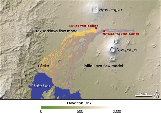
In late November 2006, Nyamuragira Volcano in the Democratic Republic of Congo erupted, and local scientists feared the lava flows would impact nearby towns. Between the volcano’s activity and the armed civil and interstate conflict that has plagued the region for nearly a decade, however, personal inspection of the location and extent of the lava flows was nearly impossible. Scientists at the Goma Volcano Observatory sent out an international appeal for satellite observations of the eruption. At NASA’s Jet Propulsion Laboratory, an automated system known as the Volcano Sensor Web proved itself to be a step ahead of the scientists. Within days of the eruption, the system scheduled satellite observations of the volcano and relayed crucial data to volcanologists. This image shows the Nyamuragira region, including neighboring Nyiragongo Volcano, Lake Kivu, and the lakeside town of Sake. The image uses elevation data from the Shuttle Radar Topography Mission, with white indicating the highest elevation and green indicating the lowest. Nyamuragira is a large, gently sloping shield volcano. Nyiragongo is a smaller, steeply sloped stratovolcano.The image shows two predictions of where the lava from the November 2006 eruption would flow based on scientists’ original estimate of the vent location and a more accurate location identified by NASA’s Earth Observing-1 (EO-1) satellite. The first location reported by the Goma Volcano Observatory was close—within a few kilometers. Given the area’s hilly terrain and the volcano’s fast-flowing lava, however, even a relatively small uncertainty could dramatically change the predicted path of the lava. EO-1 observations of the volcano provided a precise location and enabled modelers to refine predicted lava flow. Whereas the initial model (pale purple) predicted lava flowing both east and west, the revised model (deep yellow) showed all of the lava heading for the town of Sake. The lava did not actually reach the town, but the revised prediction enabled authorities to allocate resources most efficiently. For more information on how the Volcano Sensor Web assisted scientists studying this eruption, see the Earth Observatory feature Observing Volcanoes, Satellite Thinks for Itself. NASA image by Jesse Allen, based on model data provided by L’Istituto Nazionale di Geofisica e Vulcanologia (INGV). Recommend this Image to a Friend Back to: Newsroom
Also see |
View Images Index
| ||
|
Subscribe to the Earth Observatory About the Earth Observatory Contact Us Privacy Policy and Important Notices Responsible NASA Official: Lorraine A. Remer Webmaster: Goran Halusa We're a part of the Science Mission Directorate |