 |
||||
|
|
|
|||


| |
Real-time Meteorological Observation Network
Collaborators
Green Energy Ohio - establishment of a meteorology monitoring
site to determine the feasibility of wind energy generation on Lake Erie
(Green Energy
Ohio web site)
NOAA Thunder Bay National Marine Sanctuary (TBNMS
web site)
Tom Townsend, NOAA NWS Central Region Observations program
manager - establishing real-time on-water observation sites based on the
GLERL met data acquisition system design.
Richard Wagenmaker, NWS Meteorologist in Charge, Detroit
Office
Executive Summary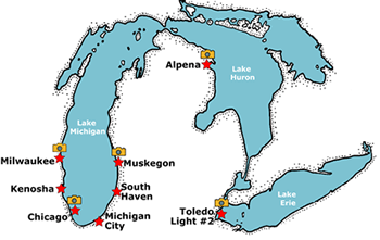
The objective of this project is to establish a network of real-time meteorological stations at exposed coastal sites around southern Lake Michigan (Chicago, Milwaukee, Kenosha, South Haven and Michigan City) for the purposes of analyzing the impact of the meteorological data obtained by this network on nowcasts and forecasts of waves and circulation in the Great Lakes Coastal Forecasting System. These sites and sites located at Muskegon and Alpena are also operated to demonstrate the feasibility of installing and maintaining a real-time meteorological network in the Great Lakes, and to make the data available in real-time to NWS forecasters and the coastal user community.
GLERL's Experimental Great Lakes Coastal Forecasting System
+ view experimental GLCFS system
Objectives
- To establish a network of real-time meteorological stations at exposed coastal sites around southern Lake Michigan: Chicago, Milwaukee, Kenosha, South Haven, and Michigan City.
- To obtain observations from these stations and Muskegon and Alpena and make them available to NWS forecast offices at Milwaukee, Chicago, Gaylord, and Grand Rapids in real-time.
- To analyze the impact of the meteorological data obtained by this network on nowcasts and forecasts of waves and circulation in the Great Lakes Coastal Forecasting System
- To demonstrate the feasibility of installing and maintaining a real-time meteorological network in the Great Lakes
Project Rationale
 This project grew out of the meteorological
station deployments during the field years of the Episodic Events Great
Lakes Experiment program (EEGLE web site) (1998-2000)
and the GLERL-funded Chicago Real-time Met Station project (2000). In
the EEGLE project, self-recording stations were established at well-exposed
coastal sites in Saugatuck, St. Joseph, Michigan City, Kenosha, and Milwaukee.
Instruments at the stations included a Campbell Scientific anemometer
and air temperature sensor. Data from the stations were recorded internally
and downloaded once every several months. Analysis of these data indicated
that high-quality meteorological measurements from exposed coastal sites
were critical to estimating overwater wind fields for modeling currents
and waves. Results from EEGLE modeling studies show that without these
measurements, the accuracy of model results is severely compromised. This
network now provides critical data needed to quantitatively assess the
limits on the accuracy of wave and circulation models caused by inadequate
winds.
This project grew out of the meteorological
station deployments during the field years of the Episodic Events Great
Lakes Experiment program (EEGLE web site) (1998-2000)
and the GLERL-funded Chicago Real-time Met Station project (2000). In
the EEGLE project, self-recording stations were established at well-exposed
coastal sites in Saugatuck, St. Joseph, Michigan City, Kenosha, and Milwaukee.
Instruments at the stations included a Campbell Scientific anemometer
and air temperature sensor. Data from the stations were recorded internally
and downloaded once every several months. Analysis of these data indicated
that high-quality meteorological measurements from exposed coastal sites
were critical to estimating overwater wind fields for modeling currents
and waves. Results from EEGLE modeling studies show that without these
measurements, the accuracy of model results is severely compromised. This
network now provides critical data needed to quantitatively assess the
limits on the accuracy of wave and circulation models caused by inadequate
winds.
 After
the EEGLE project field years were completed, there was interest at GLERL
and at NWS in continuing the meteorological observation program at some
of the EEGLE sites. There was also interest from NWS Chicago in real-time
access to the meteorological data from the new GLERL lake observatory
at the Chicago water intake crib. By changing the data acquisition procedure
to real-time instead of self-recording, GLERL took advantage of the meteorological
data in the Great Lakes Coastal Forecasting System, and NWS was able to
use the data in preparation of marine forecasts and warnings for southern
Lake Michigan.
After
the EEGLE project field years were completed, there was interest at GLERL
and at NWS in continuing the meteorological observation program at some
of the EEGLE sites. There was also interest from NWS Chicago in real-time
access to the meteorological data from the new GLERL lake observatory
at the Chicago water intake crib. By changing the data acquisition procedure
to real-time instead of self-recording, GLERL took advantage of the meteorological
data in the Great Lakes Coastal Forecasting System, and NWS was able to
use the data in preparation of marine forecasts and warnings for southern
Lake Michigan.
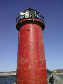
In September 2004 the met station at Saugatuck, MI was replaced by one at South Haven, MI. In addition, a met station was added at the Toledo
Data from all operating systems are used in GLERL’s Great Lakes Coastal Forecasting System and are available in real-time to the entire Great Lakes community through the NOAAPORT system (NOAAPORT web site).
Collaborative Progess
- NOAA COMPLETES FORECAST SYSTEM FOR GREAT LAKES System Aids Navigation,
Boating, Search and Rescue, and Emergency Response The pioneering research
for the Great Lakes forecast system was constructed in collaboration
between the NOAA Great Lakes Environmental Research Laboratory and The
Ohio State University.
+ Read NOAA magazine article - On March 31, the Center for Operational Oceanographic Products and Services (CO-OPS web site) teamed with two others NOAA Line Offices and brought on-line three new operational coastal forecast systems for the Great Lakes. These new systems cover lakes Superior, Huron and Ontario and provide lake carriers, mariners, port managers, emergency response teams and recreational boaters with present and future conditions of water levels, water currents and water temperatures. Together with CO-OPS's operational systems for the lakes Erie and Michigan, which were implemented in October 2005, these new systems complete the Great Lakes Operational Forecast System (GLOFS web site). CO-OPS maintains GLOFS in an operational environment 24 hours a day, 7 days a week.
![]()
GLERL Accomplishments 2005
- Milwaukee site: added new sensors, data acquisition
components, and connected into the Milwaukee observing system node
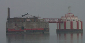
This eliminated cell phone charges and strengthened collaborations with UW-Milwaukee and Pier Wisconsin, a non-profit organization committed to raising awareness of the Great Lakes ecosystem and environmental concerns. - Toledo site: added to the National Data Buoy Center list of stations for distribution on the NOAAPORT system providing access to the data by Great Lakes marine forecasters.
- Cleveland water intake site: was established by Green Energy of Ohio in consultation with GLERL. The data will be made accessible to NWS marine forecasters in 2006 through NOAA PORT by using the existing Cleveland observing system node established in a collaborative effort by GLERL and NASA Glenn Research. The wind profiles from the site will be used by GLERL investigators for wave research. This site will not be added to the GLERL met site as it will be maintained by Green Energy.
- Alpena site: was moved from the present site to a more exposed site at the Alpena harbor entrance.
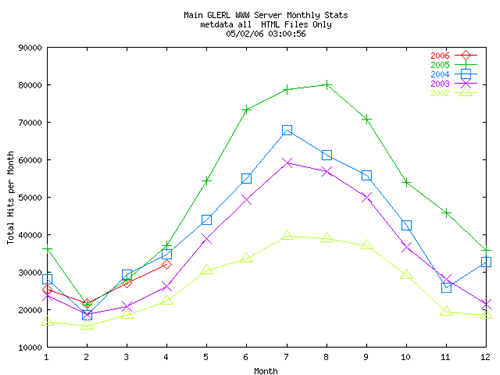
Figure 1. 2006 Realtime Meteorological Data Network monthly hits on GLERL's web site.
Products
Real-time weather data and webcam images from the Meteorological Observation Network are available at: www.glerl.noaa.gov/metdata/![]()
![]()
Last updated: 2006-06-02 mbl