| HOME | ARCHIVES | FORECASTS | IMAGERY | ABOUT TPC | RECONNAISSANCE |
|---|
![[NCEP Logo]](https://webarchive.library.unt.edu/eot2008/20080916172343im_/http://www.nhc.noaa.gov/graphics/ncep.gif) Text-only version (printer friendly) TROPICAL CYCLONE REPORTSTropical Depression Two Tropical Storm Barry Tropical Storm Chantal Tropical Storm Dean Hurricane Erin Hurricane Felix Hurricane Gabrielle Tropical Depression Nine Hurricane Humberto Hurricane Iris Tropical Storm Jerry Hurricane Karen Tropical Storm Lorenzo Hurricane Michelle Hurricane Noel Hurricane Olga |
Tropical Cyclone Report
|
||||||||||||||||||||||||||||||||||||||||||||||||||||||||||||||||||||||||||||||||||||||||||||||||||||||||||||||||||||||||||||||||||||||||||||||||||||||||||||||||||||||||||||||||||||||||||||||||||||||||||||||||||||||||||||||||||||||||||||||||||||||||||||||||||||||||||||||||||||||||||||||||||||||||||||||||||||||||||||||||||||||||||||||||||||||||||||||||||||||||||||||||||||||||||||||||||||||||||||||||||||||||||||||||||||||||||||||||||||||||||||||||||||||||||||||||||||||||||||||||||||||||||||||||||||||||||||||||||||||||||||||||||||||||||||||||||||||||||||||||||||||||||||||||||||||||||||||||||||||||||||||||||||||||||||||||||||||||||||||||||||||||||||||||||||||||||||||||||||||||||||||||||||||||||||||||||||||||||||||||||||||||||||||||||||||||||||||||||||||||||||||||||||||||||||||||||||||||||||||||||||||||||||||||||||||||||||||||||||||||||||||||||||||||||||||||||||||||||||||||||||||||||||||||||||||||||||||||||||||||||||||||||||||||||||||||||||||||||||||||||||||||||||||||||||||||||||||||||||||
| Date/Time (UTC) | Position | Pressure (mb) | Wind Speed (kt) | Stage | |
|---|---|---|---|---|---|
| Lat. (°N) | Lon. (°W) | ||||
| 11 /1800 | 25.8 | 84.1 | 1010 | 25 | tropical depression |
| 12 /0000 | 25.7 | 84.6 | 1009 | 25 | " |
| 12 /0600 | 25.7 | 85.0 | 1008 | 25 | " |
| 12 /1200 | 25.6 | 85.3 | 1008 | 25 | " |
| 12 /1800 | 25.4 | 85.4 | 1007 | 30 | " |
| 13 /0000 | 25.1 | 85.7 | 1005 | 30 | " |
| 13 /0600 | 25.2 | 85.3 | 1005 | 30 | " |
| 13 /1200 | 25.3 | 84.9 | 1003 | 35 | tropical storm |
| 13 /1800 | 25.4 | 84.5 | 998 | 40 | " |
| 14 /0000 | 25.4 | 84.1 | 997 | 45 | " |
| 14 /0600 | 25.8 | 83.6 | 992 | 50 | " |
| 14 /1200 | 27.1 | 82.6 | 983 | 60 | " |
| 14 /1800 | 28.0 | 81.8 | 994 | 45 | " |
| 15 /0000 | 28.6 | 81.4 | 995 | 40 | " |
| 15 /0600 | 28.6 | 80.9 | 995 | 40 | " |
| 15 /1200 | 28.9 | 80.1 | 998 | 40 | " |
| 15 /1800 | 29.8 | 79.0 | 999 | 45 | " |
| 16 /0000 | 30.4 | 77.9 | 998 | 50 | " |
| 16 /0600 | 30.8 | 76.8 | 998 | 50 | " |
| 16 /1200 | 31.6 | 74.9 | 995 | 55 | " |
| 16 /1800 | 32.3 | 72.8 | 995 | 55 | " |
| 17 /0000 | 33.1 | 70.7 | 991 | 65 | hurricane |
| 17 /0600 | 34.0 | 68.5 | 991 | 65 | " |
| 17 /1200 | 35.3 | 66.6 | 983 | 70 | " |
| 17 /1800 | 36.2 | 64.7 | 983 | 70 | " |
| 18 /0000 | 36.9 | 62.9 | 987 | 60 | tropical storm |
| 18 /0600 | 37.9 | 61.8 | 990 | 55 | " |
| 18 /1200 | 39.0 | 60.4 | 990 | 55 | " |
| 18 /1800 | 40.2 | 58.9 | 980 | 60 | tropical storm |
| 19 /0000 | 41.5 | 57.5 | 975 | 60 | " |
| 19 /0600 | 42.8 | 55.5 | 976 | 55 | extratropical |
| 19 /1200 | 43.5 | 54.0 | 978 | 60 | " |
| 19/1800 | 46.5 | 52.0 | 986 | 60 | " |
| 20/0000 | 48.5 | 48.5 | 988 | 60 | " |
| 20/0600 | 50.0 | 46.0 | 986 | 60 | " |
| 20/1200 | 52.0 | 43.0 | 984 | 60 | " |
| 20/1800 | 54.0 | 40.0 | 981 | 65 | " |
| 21/0000 | 55.0 | 37.5 | 981 | 65 | " |
| 21/0600 | 55.0 | 35.0 | 981 | 65 | " |
| 21/1200 | 56.0 | 32.5 | 984 | 60 | " |
| 21/1800 | 57.5 | 31.0 | 987 | 55 | " |
| 22/0000 | merged with another extratropical storm | ||||
| 14/1200 | 27.1 | 82.6 | 983 | 60 | landfall near Venice, FL |
| 19 /0000 | 41.5 | 57.3 | 975 | 60 | minimum pressure |
| Minimum Sea-level Pressure | Maximum Surface Wind Speed (kt) | |||||||
|---|---|---|---|---|---|---|---|---|
| Location | Date/ Time (UTC) | Press. (mb) | Date/ Timea (UTC) | Sust. Windb (kts) | Peak Gust (kts) | Storm Surgec (ft) | Storm Tided (ft) | Rain (storm total) (in) |
| Florida | ||||||||
| C-MAN stations | ||||||||
| Sombrero Key | 14/1000 | 1004.7 | 14/0600 | 40 | 45 | 1.1 | ||
| Dry Tortugas | 14/0800 | 1001.7 | 14/0300 | 38 | 45 | 2.54 | ||
| Sand Key | 14/0800 | 1003.1 | 14/0900 | 36 | 53 | |||
| Molasses Reef | 14/1000 | 1004.7 | 14/1200 | 36 | 42 | |||
| Long Key | 14/1100 | 1005.1 | 14/1100 | 30 | 34 | 0.95 | ||
| Cedar Key | 14/2000 | 1002.9 | 15/0100 | 17 | 25 | |||
| Venice | 14/1200 | 983.1 | 14/1400 | 50 | 63 | |||
| Saint Augustine | 14/2200 | 999.1 | 14/2220 | 51 | 65 | |||
| Buoys | ||||||||
| 42036 | 14/1200 | 1005.2 | 14/1200 | 29 | 37 | |||
| 42003 | 13/2100 | 1003.3 | 14/0200 | 27 | 35 | |||
| 41009 | 15/0900 | 997.7 | 14/1500 | 33 | 44 | |||
| 41010 | 15/2000 | 1000.7 | 15/1600 | 27 | 35 | |||
| CM3 (U. of S. FL)e | 14/0744 | 992.1 | 14/0429 | 36 | ||||
| EGK (U. of S. FL)e | 14/1615 | 46 | ||||||
| NA2 (U. of S. FL)e | 14/1210 | 44 | 18 | |||||
| Key West | 0.5 | |||||||
| Key West Int. Airport | 14/0929 | 1003.7 | 14/0929 | 36 | 42 | 0.95 | ||
| NW FL Bay Comps | 14/0900 | 1003.1 | 14/1400 | 33 | 42 | 0.95 | ||
| Marathon Airport | 14/1009 | 1005.4 | 14/1052 | 23 | 39 | 1.23 | ||
| Tavernier | 1.40 | |||||||
| Everglades City | 14/1200 | 1000.0 | 14/1200 | 44 | 61 | |||
| Naples | 14/0950 | 999.4 | 14/1146 | 24 | 41 | 3.06 | ||
| Flamingo | 14/1000 | 1002.4 | 14/0900 | 45 | 54 | |||
| Ochopee | 4.30 | |||||||
| Miles City | 2.32 | |||||||
| Racoon Point | 1.55 | |||||||
| The Villages | 14/2025 | 996.0 | 14/2325 | 26 | ||||
| Brooksville | 15/1845 | 998.6 | 15/0135 | 25 | 40 | |||
| New Pass | 14/0125 | 996.1 | 14/1207 | 51 | ||||
| St. Petersburg (PIE) | 14/1321 | 998.3 | 14/1609 | 36 | 47 | |||
| St. Petersburg (SPG) | 14/1446 | 995.9 | 14/1521 | 38 | 50 | |||
| Tampa | 14/1525 | 997.0 | 14/1603 | 32 | 43 | |||
| Winter Haven | 14/1752 | 992.6 | 14/1223 | 35 | 42 | |||
| Sarasota | 14/1310 | 991.2 | 14/1528 | 41 | 54 | 8.29 | ||
| Punta Gorda | 14/1227 | 993.9 | 14/1212 | 42 | 49 | |||
| Fort Myers (FMY) | 14/1046 | 996.3 | 14/1208 | 31 | 40 | |||
| Fort Myers (RSW) | 14/1144 | 998.6 | 14/1007 | 27 | 38 | |||
| Macdill AFB | 14/1458 | 996.3 | 14/1148 | 21 | 40 | |||
| Lakeland | 14/1650 | 994.2 | 14/1450 | 20 | 45 | |||
| Pinellas County | 1.0 | 2.9 | ||||||
| Charlotte County | 5.1 | 6.2 | ||||||
| Lee County | 3.4 | 3.8 | ||||||
| Daytona Beach | 14/1647 | 998.6 | 14/1052 | 37 | 43 | 7.69 | ||
| Vero Beach | 15/0454 | 998.9 | 14/1346 | 29 | 37 | 2.15 | ||
| Melbourne | 15/0519 | 997.9 | 14/1623 | 25 | 35 | 4.18 | ||
| Ft. Peirce | 15/0504 | 999.6 | 15/0244 | 24 | 33 | 1.97 | ||
| Orlando Int. Airport | 14/1412 | 994.5 | 14/1254 | 31 | 39 | 4.02 | ||
| Orlando Exec. Airport | 14/1516 | 995.2 | 14/1326 | 27 | 36 | 4.74 | ||
| Leesburg | 14/1538 | 995.6 | 15/0045 | 31 | 39 | 7.98 | ||
| Sanford | 14/1522 | 995.9 | 14/1525 | 27 | 33 | 5.04 | ||
| Titusville | 14/1950 | 998.3 | ||||||
| Patrick AFB | 15/0755 | 998.0 | 14/1421 | 39 | 86 | 6.26 | ||
| Shuttle Landing | 15/0755 | 998.0 | 15/1841 | 22 | 36 | 4.56 | ||
| Pierson | 13.6 | |||||||
| Umatilla | 12.7 | |||||||
| Okahumpka | 9.10 | |||||||
| Tavares | 8.26 | |||||||
| Apopka | 5.53 | |||||||
| Avalon | 4.45 | |||||||
| Jacksonville | 15/0459 | 1004.7 | 15/0412 | 29 | 36 | |||
| KCRG | 15/0707 | 1003.7 | 15/0848 | 27 | 36 | |||
| KNRB | 15/0507 | 1003.4 | 15/0402 | 41 | 47 | |||
| KNIP | 15/0701 | 1003.0 | 15/0927 | 34 | 41 | |||
| Cecil Field | 15/0039 | 1004.1 | 15/0906 | 30 | 39 | |||
| Kings Bay Naval Stn. | 15/0627 | 1005.1 | 15/0413 | 23 | 35 | |||
| Gainesville | 14/2331 | 1002.4 | 14/2044 | 24 | 29 | |||
| St. Simons Island | 15/0449 | 1005.8 | 15/0532 | 34 | 42 | |||
| KAMG | 15/0049 | 1009.1 | 15/1900 | 14 | 22 | |||
| Bunnell | 15/0619 | 31 | 42 | |||||
| Lake City | 14/2356 | 1005.4 | 15/1617 | 20 | 29 | |||
| Fernandina Beach | 15/0500 | 1005.2 | 15/1000 | 28 | 36 | |||
| Mayport | 15/0600 | 1003.7 | 14/2300 | 36 | 46 | |||
| St. Augustine | 15/0800 | 1003.2 | 14/2300 | 46 | 64 | |||
| Amelia Island | 52 | |||||||
| Hastings | 14/2100 | 20 | ||||||
| Flagler Bch Fire Stn. | 15/0900 | 999.7 | ||||||
| aDate/time is for wind gust when both sustained and gust are listed. bExcept as noted, sustained wind averaging periods for C-MAN and land-based ASOS reports are 2 min; buoy averaging periods are 8 min. cStorm surge is water height above normal astronomical tide level. dStorm tide is water height above National Geodetic Vertical Datum (1929 mean sea level). eU. of South Florida buoy averaging periods vary from 1 to 15 minutes. |
||||||||
| Ship Name or Call Sign | Date/Time (UTC) | Lat. (°N) | Lon. (°W) | Wind dir/speed (deg/kt) | Pressure (mb) |
|---|---|---|---|---|---|
| DCUW | 13/0600 | 26.5 | 84.8 | 080/37 | 1010.0 |
| CZ523 | 13/1200 | 24.0 | 83.5 | 170/35 | 1006.4 |
| DCUW | 13/1200 | 25.8 | 84.2 | 130/39 | 1007.2 |
| DCUW | 13/1800 | 25.3 | 83.9 | 160/45 | 1003.9 |
| DCUW | 14/0600 | 24.2 | 83.5 | 220/37 | 1004.3 |
| WGJT | 14/0600 | 29.5 | 80.0 | 060/36 | 1008.0 |
| DCUW | 14/1200 | 23.5 | 83.4 | 210/39 | 1007.0 |
| KRHX | 14/1800 | 28.1 | 80.1 | 180/37 | 1000.5 |
| DGSE | 15/1800 | 28.7 | 79.1 | 030/35 | 1005.0 |
| WGXO | 15/1800 | 30.4 | 80.4 | 030/40 | 1003.0 |
| WPKD | 15/1800 | 32.1 | 80.0 | 020/49 | 1009.0 |
| ELJJ5 | 15/1800 | 33.9 | 76.2 | 030/40 | 1014.0 |
| WPGJ | 16/0000 | 29.5 | 80.1 | 050/37 | 1006.5 |
| DGSE | 16/0000 | 30.5 | 78.5 | 360/49 | 999.0 |
| WGXO | 16/0000 | 31.4 | 79.9 | 010/48 | 1006.0 |
| WPKD | 16/0000 | 32.5 | 78.7 | 030/50 | 1006.8 |
| ELJJ5 | 16/0000 | 33.0 | 78.1 | 020/44 | 1010.3 |
| KRPDD | 16/0000 | 32.7 | 74.2 | 080/58 | 1008.1 |
| WPKD | 16/0600 | 33.3 | 77.6 | 020/46 | 1007.6 |
| PDHW | 16/0600 | 32.7 | 77.7 | 050/43 | 1007.0 |
| KRPDD | 16/0600 | 32.7 | 72.4 | 120/39 | 1008.1 |
| ELJJ5 | 16/0600 | 33.2 | 77.8 | 010/44 | 1009.0 |
| KS004 | 16/1200 | 24.9 | 75.4 | 280/45 | - |
| WPKD | 16/1800 | 35.0 | 75.2 | 010/43 | 1010.0 |
| KRPDD | 16/1800 | 32.8 | 68.3 | 140/58 | 1009.1 |
| KS004 | 16/1800 | 23.7 | 73.6 | 280/40 | - |
| MZBM7 | 16/1800 | 34.1 | 73.1 | 040/40 | 1003.1 |
| KIRF | 17/0000 | 29.3 | 69.8 | 200/36 | 1009.2 |
| MZBM7 | 17/0000 | 35.6 | 73.8 | 040/40 | 1006.7 |
| KS004 | 17/0000 | 22.4 | 71.8 | 300/38 | - |
| KRPDD | 17/0600 | 32.9 | 64.0 | 160/47 | 1009.1 |
| PCTG | 17/1800 | 34.6 | 60.6 | 200/39 | 1006.9 |
| WMLH | 18/1200 | 41.4 | 57.2 | 100/36 | 1005.0 |
| WRYX | 18/1200 | 33.2 | 66.0 | 260/35 | 1009.0 |
| WMLH | 18/1800 | 41.4 | 59.7 | 090/35 | 984.5 |
| WMLH | 19/0000 | 41.4 | 61.7 | 010/41 | 1006.5 |
| LAVX4 | 19/0600 | 36.1 | 53.4 | 290/36 | 1013.0 |
| DEDI | 19/1200 | 44.7 | 56.1 | 320/45 | 1002.2 |
| C6MS4 | 19/1800 | 46.8 | 40.0 | 160/35 | 1019.0 |
| MYMX5 | 19/1800 | 45.4 | 42.3 | 150/35 | 1010.8 |
| 4XFE | 19/1800 | 44.6 | 42.6 | 150/40 | 1011.0 |
| 4XGV | 19/1800 | 42.9 | 48.2 | 220/40 | 1012.5 |
| 4XFE | 20/0000 | 44.5 | 40.0 | 160/35 | 1014.4 |
| C6MS4 | 20/0000 | 46.2 | 41.6 | 170/56 | 1005.0 |
| 4XGW | 20/0000 | 42.5 | 49.9 | 270/40 | 1024.0 |
| C6RM7 | 20/0000 | 46.4 | 40.4 | 150/45 | 1008.4 |
| GBBA | 20/0000 | 47.7 | 37.7 | 180/40 | 1012.5 |
| C6MS4 | 20/0600 | 45.6 | 42.7 | 270/39 | 1007.0 |
| S6TY | 20/0600 | 45.6 | 36.7 | 170/39 | 1014.0 |
| GBBA | 20/0600 | 47.8 | 36.0 | 130/40 | 1012.4 |
| V7CG8 | 20/0600 | 47.6 | 36.4 | 190/37 | 1014.0 |
| ZCBE7 | 20/1800 | 55.5 | 42.5 | 330/50 | 995.0 |
| OXTS2 | 21/0600 | 58.5 | 42.4 | 010/38 | 1009.8 |
| Date/Time | Action | Location |
|---|---|---|
| 13 / 2100 | tropical storm warning issued | Craig Key - Dry Tortugas, FL |
| " | " | Flamingo - Suwanee River, FL |
| " | hurricane watch issued | Chokoloskee - Tarpon Springs, FL |
| 14 / 0300 | tropical storm watch issued | Jupiter Inlet - St. Augustine, FL |
| 14 / 0900 | tropical storm warning issued | Jupiter Inlet - St. Augustine, FL |
| " | tropical storm warning issued | Lake Okeechobee, FL |
| 14 / 1500 | hurricane watch removed | Chokoloskee - Tarpon Springs, FL |
| 14 / 2100 | tropical storm warning discontinued | Craig Key - Dry Tortugas, FL |
| " | tropical storm warning discontinued | Flamingo - Suwanee River, FL |
| " | tropical storm warning discontinued | Lake Okeechobee, FL |
| 15 / 1500 | tropical storm warning discontinued | St. Augustine - Sebastian Inlet, FL |
| 16 / 0300 | all warnings discontinued |

Figure 1: Best track positions for Hurricane Gabrielle, 11-19 September 2001. Track during the extratropical stage (after 19/0000 UTC) is based on analyses from the NOAA Marine Prediction Center. Inset is an enlargement of loop over southeastern Gulf of Mexico.
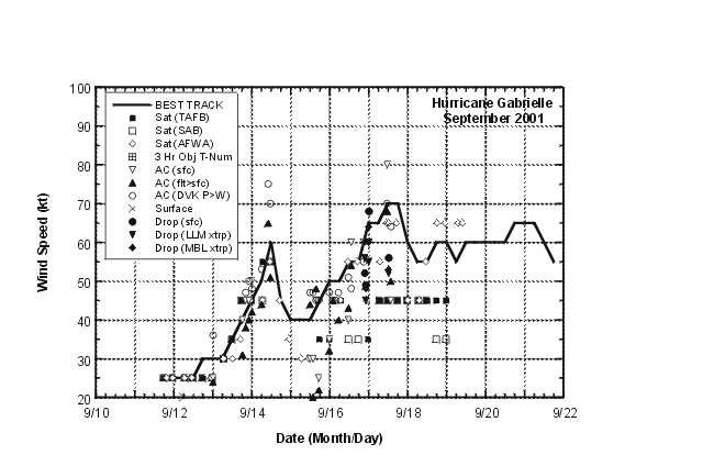
Figure 2: Best track maximum sustained surface wind speed curve for Hurricane Gabrielle, 11-19 September 2001, and the observations on which the best track curve is based. Aircraft observations have been adjusted for elevation using 90%, 80%, and 80% reduction factors for observations from 700 mb, 850 mb, and 1500 ft, respectively. Dropwindsonde observations include actual 10 m winds (sfc), as well as surface estimates derived from the mean wind over the lowest 150 m of the wind sounding (LLM), and from the sounding boundary layer mean(MBL). Estimates during the extratropical stage are from the NOAA Marine Prediction Center.
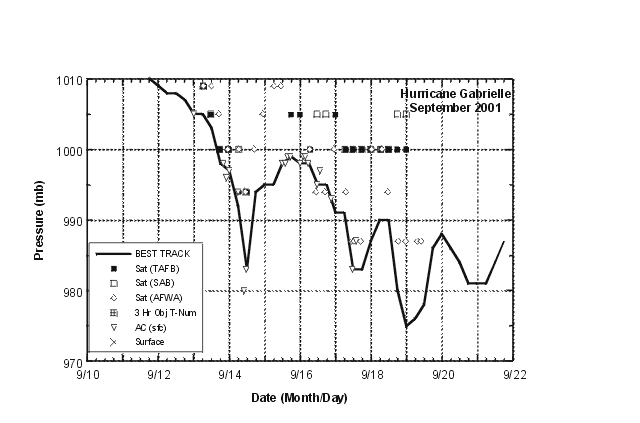
Figure 3: Best track minimum central pressure curve for Hurricane Gabrielle, 11-19 September 2001, and the observations on which the best track curve is based. Estimates during the extratropical stage are based on analyses from the NOAA Marine Prediction Center.