![[NCEP Logo]](https://webarchive.library.unt.edu/eot2008/20080916171759im_/http://www.nhc.noaa.gov/graphics/ncep.gif)
Text-only version
(printer friendly)
TROPICAL CYCLONE REPORTS
Tropical Storm Allison
Tropical Depression Two
Tropical Storm Barry
Tropical Storm Chantal
Tropical Storm Dean
Hurricane Erin
Hurricane Felix
Hurricane Gabrielle
Tropical Depression Nine
Hurricane Humberto
Hurricane Iris
Tropical Storm Jerry
Hurricane Karen
Tropical Storm Lorenzo
Hurricane Michelle
Hurricane Noel
Hurricane Olga
|
Tropical Cyclone Report
Hurricane Noel
4 - 6 November 2001
James L. Franklin
National Hurricane Center
14 November 2001
Hurricane Noel was a short-lived hurricane of subtropical
origin.
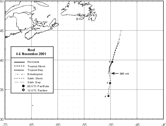
a. Synoptic History
Noel developed from a non-tropical occluded low that gradually
lost its frontal structure. The first appearance of the frontal low
in surface synoptic maps was at 0000 UTC 2 November, when a 1002-mb
low was analyzed near 32N, 42W. The low deepened and occluded while
it moved slowly west-northwestward over the next 48 h. The official
"best track" of Noel begins at 0000 UTC 4 November when the system,
then 775 n mi south of Cape Race, Newfoundland, was being
classified as a subtropical cyclone by both the Tropical Analysis
and Forecast Branch (TAFB) and the Satellite Analysis Branch
(SAB).
The best track chart of the tropical cyclone's path is given in
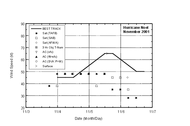
Figure 1, with the wind and pressure histories shown in
Figure 2 and Figure 3, respectively.
The best track positions and intensities are
listed in Table 1. The subtropical cyclone drifted northward
initially, its speed increasing to about 10 kt by late on 4
November. Convection, which had been limited to the northern
semicircle, became more symmetric as it formed a ring around the
center with a radius of about 60 n mi. The system developed a weak
mid-level warm core early on 5 November, strengthened and became a
hurricane with 65 kt winds at 1200 UTC that day, about 535 n mi
south-southeast of Cape Race. By 0000 UTC 6 November, westerly wind
shear began to displace and limit convection near the center, and
Noel weakened to a tropical storm. Noel then accelerated to the
north, and had lost all its convection by 1200 UTC that day, when
it became extratropical about 285 n mi southeast of Cape Race. The
extratropical low was absorbed into a larger extratropical system
later that day.
b. Meteorological Statistics
Observations in Noel (Figure 2 and Figure 3)
include satellite-based
Dvorak technique intensity estimates from TAFB and SAB, and the U.S.
Air Force Weather Agency (AFWA). Initial subtropical
classifications of 45-50 kt are consistent with a QuikSCAT pass
near 0800 UTC 4 November showing peak winds of 45 kt. Although
satellite intensity estimates remained constant over the next 30 h,
a report from the ship Tellus (call sign
WRYG, Figure 2, Table 2) of
65 kt at 1400 UTC 5 November
indicates the system had strengthened. This ship report is the
basis for the peak intensity estimate of 65 kt. Microwave sounding
data suggested that a weak warm core near 550 mb had developed by
about 1000 UTC on the 5th.
c. Casualty and Damage Statistics
There were no reports of damage or casualties associated with
Noel.
Forecast and Warning Critique
Only five forecasts were issued for Noel, too few for a
meaningful forecast evaluation. Apart from marine warnings issued
by the government of Canada, there were no watches and warnings
associated with Noel.
Table 1: Best track for Hurricane Noel, 4 - 6 November 2001.
Date/Time
(UTC) | Position | Pressure
(mb) | Wind Speed
(kt) | Stage |
| Lat. (°N) | Lon. (°W) |
| 04 / 0000 | 33.9 | 50.4 | 988 | 45 | subtropical storm |
| 04 / 0600 | 34.1 | 50.4 | 990 | 45 | " |
| 04 / 1200 | 34.3 | 50.4 | 993 | 45 | " |
| 04 / 1800 | 35.2 | 50.3 | 993 | 50 | " |
| 05 / 0000 | 36.1 | 50.1 | 991 | 55 | " |
| 05 / 0600 | 37.0 | 50.1 | 988 | 60 | " |
| 05 / 1200 | 37.8 | 50.3 | 986 | 65 | hurricane |
| 05 / 1800 | 38.8 | 50.2 | 986 | 65 | " |
| 06 / 0000 | 39.7 | 49.7 | 990 | 60 | tropical storm |
| 06 / 0600 | 41.3 | 49.2 | 994 | 55 | " |
| 06 / 1200 | 43.0 | 48.5 | 996 | 50 | extratropical |
| 06 / 1800 | 45.0 | 48.0 | 1000 | 50 | " |
| 07 / 0000 | | | | | absorbed by extratropical low |
| 05 / 1200 | 37.8 | 50.3 | 986 | 65 | minimum pressure |
Table 2: Selected ship or buoy reports
with winds of at least 34 kt for Hurricane Noel, 4-6 November
2001.
| Ship Name or Call Sign | Date/Time (UTC) | Lat. (°N) | Lon. (°W) | Wind dir/speed (deg/kt) | Pressure (mb) |
| ZCBO5 | 04/0000 | 31.8 | 47.1 | 150/35 | 1005.5 |
| WRYG | 05/1200 | 37.0 | 49.5 | 180/60 | 992.0 |
| WRYG | 05/1400 | 37.0 | 50.1 | 240/65 | 994.0 |
| WRYG | 05/1500 | 37.0 | 50.5 | 240/51 | 994.2 |
| WRYG | 05/1800 | 36.8 | 51.3 | 270/48 | 997.8 |
| WRYG | 05/2100 | 36.8 | 52.1 | 290/45 | 1002.5 |
| WRYG | 06/0000 | 36.7 | 53.1 | 270/45 | 1006.2 |
| ELRT2 | 06/0000 | 36.5 | 49.4 | 260/37 | 1005.0 |
| WRYG | 06/0300 | 36.6 | 54.1 | 270/40 | 1009.0 |
| P6038 | 06/0900 | 46.4 | 48.4 | 120/35 | 1010.2 |
| 44145 | 06/1200 | 46.7 | 48.7 | 140/46 | 1008.4 |
|

Figure 1:
Best track positions for Hurricane Noel, 4-6 November 2001.

Figure 2:
Selected wind observations and best track
maximum sustained surface wind speed curve for Hurricane Noel, 4-6
November 2001. The peak intensity is based on a ship report of 65
kt at 1400 UTC 5 November (indicated by the "x"). Other marine
observations contributing to the best track intensity are not shown
here but are listed in Table 2.
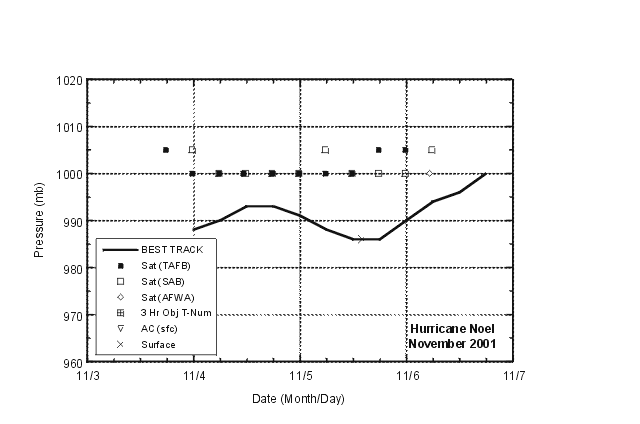
Figure 3:
Selected pressure observations and best track minimum central pressure
curve for Hurricane Noel, 4-6 November 2001.
|