|
 |
American Samoa · Guam · Puerto Rico/Virgin Islands |
 |
 |
|
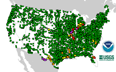
4061 Total Gauges
|
 14 Gauges: Major Flooding 14 Gauges: Major Flooding
|
|
141 Locations in Flood |
 44 Gauges: Moderate Flooding 44 Gauges: Moderate Flooding
|
|
|
 83 Gauges: Minor Flooding 83 Gauges: Minor Flooding
|
 238 Gauges: Observations older than 24 hours 238 Gauges: Observations older than 24 hours
|
 69 Gauges: Near Flood Stage 69 Gauges: Near Flood Stage
|
 12 Gauges: Out of Service 12 Gauges: Out of Service
|
 3601 Gauges: No Flooding 3601 Gauges: No Flooding
|
Last map update: Tue, Sep, 16, 2008 at 02:12:51 am EDT.
|
|

