|
August 2, 2004
RETREATING GLACIERS SPUR ALASKAN EARTHQUAKES
In a new study, NASA and United States Geological Survey (USGS) scientists found that retreating glaciers in southern Alaska may be opening the
way for future earthquakes.
The study examined the likelihood of increased earthquake activity in southern Alaska as a result of rapidly melting glaciers. As glaciers melt
they lighten the load on the Earth’s crust. Tectonic plates, that are mobile pieces of the Earth’s crust, can then move more freely. The
study appears in the July issue of the Journal of Global and Planetary Change.
Jeanne Sauber of NASA’s Goddard Space Flight Center, Greenbelt, Md., and Bruce Molnia, a research geologist at USGS, Reston, Va., used NASA
satellite and global positioning system receivers, as well as computer models, to study movements of Earth’s plates and shrinking glaciers in
the area.
“Historically, when big ice masses started to retreat, the number of earthquakes increased,” Sauber said. “More than 10,000
years ago, at the end of the great ice age, big earthquakes occurred in Scandinavia as the large glaciers began to melt. In Canada, many more
moderate earthquakes occurred as ice sheets melted there,” she added.
Southern Alaskan glaciers are very sensitive to climate change, Sauber added. Many glaciers have shrunk or disappeared over the last 100 years.
The trend, which appears to be accelerating, seems to be caused by higher temperatures and changes in precipitation.
In southern Alaska, a tectonic plate under the Pacific Ocean is pushing into the coast, which creates very steep mountains. The high mountains and
heavy precipitation are critical for glacier formation. The colliding plates create a great deal of pressure that builds up, and eventually is
relieved by earthquakes.
The weight of a large glacier on top of these active earthquake areas can help keep things stable. But, as the glaciers melt and their load on the
plate lessens, there is a greater likelihood of an earthquake happening to relieve the large strain underneath.
Even though shrinking glaciers make it easier for earthquakes to occur, the forcing together of tectonic plates is the main reason behind major
earthquakes.
The researchers believe that a 1979 earthquake in southern Alaska, called the St. Elias earthquake, was promoted by wasting glaciers in the area.
The earthquake had a magnitude of 7.2 on the Richter scale.
Along the fault zone, in the region of the St. Elias earthquake, pressure from the Pacific plate sliding under the continental plate had built up
since 1899 when previous earthquakes occurred. Between 1899 and 1979, many glaciers near the fault zone thinned by hundreds of meters and some
completely disappeared. Photographs of these glaciers, many taken by Molnia during the last 30 years, were used to identify details within areas of
greatest ice loss.
Field measurements were also used to determine how much the glacier’s ice thickness changed since the late 19th century. The
researchers estimated the volume of ice that melted and then calculated how much instability the loss of ice may have caused. They found the loss of
ice would have been enough to stimulate the 1979 earthquake.
Along with global positioning system measurements made by Sauber and Molnia a number of NASA satellites were used to document glacier variability.
Data from Landsat-7 and the Shuttle Radar Topography Mission (SRTM) were used to study glacier extent and topography. Currently, NASA’s ICESat
satellite is being used to measure how the glacier thicknesses are changing.
“In the future, in areas like Alaska where earthquakes occur and glaciers are changing, their relationship must be considered to better
assess earthquake hazard, and our satellite assets are allowing us to do this by tracking the changes in extent and volume of the ice, and movement
of the Earth,” Sauber said.
For images and information about this research on the Internet, visit:
http://www.gsfc.nasa.gov/topstory/2004/ 0715glacierquake.html
For the associated Video file, contact: Sarah Dewitt, NASA-TV at Tel. 301-286-0535
###
CONTACTS:
Gretchen Cook-Anderson
Headquarters, Washington
Phone: 202/358-0836
Krishna Ramanujan
Goddard Space Flight Center, Greenbelt, Md.
Phone: 607/273-2561
|
|
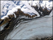
Landsat Keeps an Eye on the Bering Glacier, 1986 - 2002
Click the image to see the difference in the Bering Glacier from October 1986 to September 2002. These images were derived from the Landsat 5 and
Landsat 7 satellites, respectively. Credit: NASA/USGS
High-Resolution Image Frame 1
High-Resolution Image Frame 2

A Decade of Earthquakes in Southern Alaska
Click to see all earthquakes between magnitude 2 and 6 that have occurred in southern Alaska since 1993. In this image series the size of the ring
around each earthquake represents its relative magnitude. Credit: NASA/USGS
High-Resolution Image Frame 1
High-Resolution Image Frame 2
High-Resolution Image Frame 3
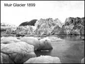
Muir Glacier 1899-2003
Click on the image to view a Quicktime movie of the comparison of the changes in the Muir Glacier from 1899 to 2003. Credit: Images courtesy of
USGS Photo Library and R.D. Karpilo, NPS

Carroll Glacier 1906-2003
Click on the image to view a Quicktime movie of the comparison of the changes in the Carroll Glacier from 1906 to 2003. Credit: Images courtesy of
USGS Photo Library and B.F. Molnia, USGS
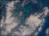
Flyover of Glacier Bay National Park
The following animation is a flying tour through Glacier Bay National Park and Preserve in southern Alaska featuring Landsat imagery draped over
elevation data. Credit: NASA/USGS
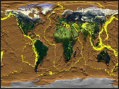
Global Earthquakes, 1960 - 1995
This animation shows a cumulative view of earthquake activity for the whole world from 1960 through 1995. The yellow dots are earthquakes and the
background image shows the topography of the ocean floor. Credit: NASA/USGS
|
