| NOAA Magazine || NOAA Home Page |
NEW DATA SHOW DOWNWARD TREND IN ARCTIC SEA ICE
 Nov.
20, 2006 � The extent of Arctic Sea ice has experienced a steady declining
trend during the past 33 years, based on a new comprehensive analysis
of satellite data by experts at the U.S.
National Ice Center, a tri-agency team from NOAA,
the U.S. Navy, and U.S.
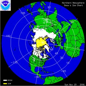
Coast Guard, based in Suitland, Md. (Click NOAA satellite
image for larger view of Northern Hemisphere daily snow and ice cover
analysis as of Nov. 19, 2006. Please credit “NOAA.”)
This new climatology dataset is expected to be a more useful and accurate tool for the research community to use than other datasets previously available. This tool can be applied to improve seasonal and climatological sea-ice-change forecast research in the Arctic.
The data set, New 30-Year Arctic Sea Ice Climatology, is derived from a 1972 - 2004 chart series that provides a close representation of the sea ice extent as derived from a combination of satellite observations, measuring instruments on the surface and model output.
"The new data sets show shrinkage in the Arctic Ocean summer ice cover of more than eight percent per decade and gives us concrete information with which to develop improved seasonal and long-term forecasts in the future," said Pablo Clemente-Colón, the ice center's chief scientist.
The new data set confirms that the overall trend in summer, winter and multi-year total ice extent is down. Both winter (maximum) and summer (minimum) sea ice extents are decreasing, although summer shrinkage is more pronounced. The percentage of multi-year ice in the winter is also decreasing significantly.
The NIC's new data set is available at the Web site of the National Snow and Ice Data Center.
Since 1972, the ice center has produced weekly, or bi-weekly operational sea-ice charts for Antarctica, and the Arctic and other ice-covered waters. These analyses are used primarily for mission planning and safe navigation. They also are incorporated into weather forecasts and serve as a comprehensive global record of sea-ice extent and concentration that can be used for climate monitoring. The ice center is celebrating its 30th anniversary as an interagency operational sea ice service with global monitoring responsibilities.
In 2007 NOAA, an agency of the U.S. Commerce Department, celebrates 200 years of science and service to the nation. Starting with the establishment of the U.S. Coast and Geodetic Survey in 1807 by Thomas Jefferson much of America's scientific heritage is rooted in NOAA. The agency is dedicated to enhancing economic security and national safety through the prediction and research of weather and climate-related events and information service delivery for transportation, and by providing environmental stewardship of the nation's coastal and marine resources. Through the emerging Global Earth Observation System of Systems (GEOSS), NOAA is working with its federal partners, more than 60 countries and the European Commission to develop a global monitoring network that is as integrated as the planet it observes, predicts and protects.
Relevant Web Sites
U.S. National Ice Center
NOAA Satellite Images of Daily Snow Cover Analysis
Media
Contact:
John Leslie, NOAA
Satellite and Information Service, (301) 713-1265