| NOAA Magazine || NOAA Home Page |
NEW NOAA ENVIRONMENTAL SATELLITE LAUNCHED, REACHES ORBIT
 May
25, 2006 � NOAA and NASA
officials confirmed that a new geostationary operational environmental
satellite, designed to track hurricanes and other severe weather impacting
the nation, successfully reached orbit last night after it was launched
from the Cape Canaveral Air Force Station in Florida. (Click
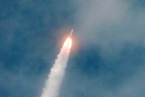
image for larger view of NOAA GOES-N satellite being launched from the
Cape Canaveral Air Force Station in Florida Wednesday aboard a Boeing
Delta IV rocket trailing a plume of smoke as it roars through the thin
cloud cover on its way to space. Click
here for high resolution version. Please credit “NASA.”)
The spacecraft separation occurred four hours and 21 minutes after the 6:11 p.m. launch. The first signal acquisition occurred six hours and 30 minutes after the launch at the Air Force Tracking Station, Diego Garcia, located in the Indian Ocean.
The NOAA satellite—initially called GOES-N—will be designated GOES-13 once it reaches final orbit. It will supply data critical for fast, accurate forecasts and warnings for severe weather, including tornadoes, winter storms and hurricanes. Additionally, it will detect solar storm activity, relay distress signals from emergency beacons, monitor the oceans and scan the landscape for the latest drought and flood conditions.
"This satellite will serve the nation by monitoring conditions that trigger dangerous weather, and it will serve the world by contributing vast amounts of observational data, as part of our contribution to the Global Earth Observation System of Systems," said retired Navy Vice Admiral Conrad C. Lautenbacher, Jr., Ph.D., undersecretary of commerce for oceans and atmosphere and NOAA administrator.
GOES-13, the first spacecraft in the new GOES-N/O/P series, features a highly stable pointing platform, which will improve the performance of the imager and sounder instruments. GOES-13 also has expanded measurements for the space and solar environment monitoring instruments. The satellite also features a new dedicated broadcast capability to be used by the Emergency Managers Weather Information Network and a new digital weather facsimile capability for higher quality transmissions of data and products.
Once it reaches geostationary orbit, GOES-13 will undergo a series of tests for approximately six months before completing its "check-out" phase. After check-out, GOES-13 is expected to be put into a storage mode at 105 degrees West. It will be ready to replace one of the two existing NOAA GOES spacecraft should either experience trouble.
NOAA's GOES satellites orbit the equatorial plane of the Earth at a speed matching the planet's rotation. This allows them to hover continuously over one position on the surface. The geostationary orbit is reached at about 22,300 miles above the Earth, high enough to allow the satellites a full-disc view of the Earth.
NOAA, an
agency of the U.S. Department of
Commerce, is dedicated to enhancing economic security and national
safety through the prediction and research of weather and climate-related
events and providing environmental stewardship of the nation's coastal
and marine resources.
Through the emerging Global Earth Observation System of Systems (GEOSS),
NOAA is working with its federal partners, 61 countries and the European
Commission to develop a global network that is as integrated as the
planet it observes, predicts and protects.
Relevant Web Sites
Images
of Launch
NOAA Satellite and Information Service
Media
Contact:
John Leslie, NOAA
Satellite and Information Service, (301) 817-4410