
Northern Rocky Mountain Science Center (NOROCK)
Home | About Us | Science | Product Library | News & Events | Staff | Students | Partners | Contact Us
Northern Rocky Mountain Science Center (NOROCK)
Home | About Us | Science | Product Library | News & Events | Staff | Students | Partners | Contact Us

Research Areas
Glacier Research
Snow and Avalanche Research
Mountain Ecosystems
Landscape Change Photography
Western Mountain Initiative
Product Library
Publications
Presentations
Glacier Recession Animation
Flattop SNOTEL Graphs
Repeat Photo Posters
Info Sheets
Photo Galleries
Repeat Photography
Panoramic Photography
Field Research
CCME Staff
Dan Fagre
Lisa McKeon
Blase Reardon
Lindsey Johnson
Erich Peitzsch
Chris Miller
Greg Pederson
Contact CCME
CCME
Glacier National Park
West Galcier, MT 59936
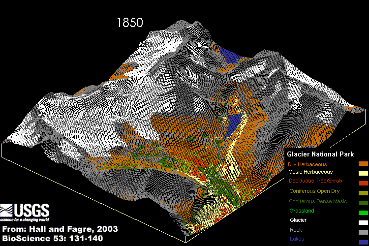
Abstract: The glaciers in the Blackfoot–Jackson Glacier Basin of Glacier National Park, Montana, decreased in area from 21.6 square kilometers (km2) in 1850 to 7.4 km2 in 1979. Over this same period global temperatures increased by 0.45ºC (± 0.15ºC).We analyzed the climatic causes and ecological consequences of glacier retreat by creating spatially explicit models of the creation and ablation of glaciers and of the response of vegetation to climate change. We determined the melt rate and spatial distribution of glaciers under two possible future climate scenarios, one based on carbon dioxide–induced global warming and the other on a linear temperature extrapolation. Under the former scenario, all glaciers in the basin will disappear by the year 2030, despite predicted increases in precipitation; under the latter, melting is slower. Using a second model, we analyzed vegetation responses to variations in soil moisture and increasing temperature in a complex alpine landscape and predicted where plant communities are likely to be located as conditions change.
The climatic causes of glacier retreat were analyzed, the melt rate (change in glacier area/decade) determined, and the topographic influences on the spatial pattern of melt were examined. Analysis of glacial area extent per decade from 1850-1979 versus a variety of climatic drivers reveals that annual precipitation and summer mean temperature together explain 92% of the loss over time. Analysis of the spatial distribution of these glaciers as a function of three topographic variables --elevation, slope and solar aspect shows elevation (or temperature) to be twice as important as slope or aspect in determining the pattern of glacier shrinkage. Using this information to parameterize the simulation model GLACPRED , the potential future glacier behavior was predicted: all glaciers in the basin will disappear by the year 2030 if current trends continue. Even if no further climatic forcing occurs, the glaciers are predicted to be all but gone by 2100 (Hall and Fagre 2003).
The simulation below reflects the predicted exponential rise in atmospheric CO2 concentrations, a 2xCO2 "global warming" scenario, with a concurrent warming of 2-3 degrees centigrade (4-5 degrees Fahrenheit) by the year 2050. In addition it assumes that precipitation, primarily in the form of rain, will increase over the same time period about 10 percent (based on the research of Dr. Steven Running, University of Montana).
The animation view of the Blackfoot-Jackson basin along the Continental Divide, includes Gunsight Lake in the foreground and a portion of Lake Ellen Wilson visible over Gunsight Pass.
Please be patient while the animation loads. Once it has loaded all the images (1850-2100) it will refresh approximately every 1.5 seconds.
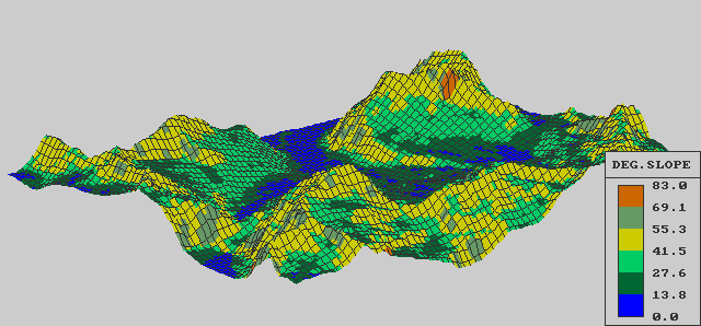
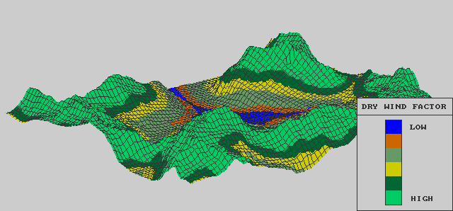
The following images display intermediate steps used in the calculations of the ecological components of the model, primarily in determining changes in the distribution of vegetation types and in calculations of annual stream discharge.
TERRAIN ELEVATION

ASPECT
SLOPE (degrees)
SUN IMPACT

SOIL MOISTURE

DRY WIND FACTOR
1981 VEGETATION - derived from MSS satellite image

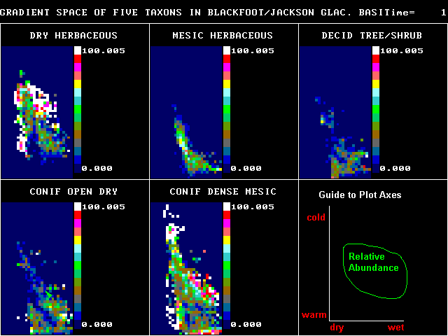
VEGETATION GRADIENT MODEL
Related Links:
Repeat photographs of Blackfoot-Jackson glacier
