Major Highlights
WARMEST APRIL ON RECORD IN U.S.
DROUGHT PERSISTS ACROSS SOUTH AND SOUTHWEST
The contiguous United States experienced its warmest April ever based on records dating back to 1895, according to scientists at NOAA's National Climatic Data Center in Asheville, N.C. Drier-than-average conditions and severe drought persisted across large portions of the southern and southwestern United States. April was also marked by a series of tornado outbreaks during the first half of the month impacting large parts of the Midwest and central Plains, into the Deep South. The global surface temperature was the seventh warmest April on record, in the U.S.
U.S. Temperature
The average temperature for the contiguous United States for April (based on preliminary data) was the warmest in the 1895-2006 period of record, breaking the previous record for the month, set in 1981. April was 4.5°F (2.5°C) above the 20th century (1901-2000) average. The anomalous warmth was particularly concentrated over the south-central United States. Texas and Oklahoma had their warmest April on record, while New Mexico, Kansas, Arkansas, Missouri and Tennessee recorded their second warmest. Twelve other states recorded one of their top five warmest Aprils on record. None of the 48 contiguous states was cooler-than average. However, temperatures across Alaska were cooler than average during April, with a statewide temperature of 0.85°F (0.47°C) below the 1971-2000 mean. The record warm temperature led to below normal residential energy demand for the U.S., as measured by the nation's Residential Energy Demand Temperature Index. Using this index, NOAA scientists determined that the nation's residential energy demand was approximately 12 percent less than what would have occurred under average climate conditions for the month.
U.S. Precipitation
Precipitation was near average for the contiguous United States, ranking 45th wettest in the 1895-2006 record. Wetter-than-normal conditions occurred in 12 states, mostly across the western and north central United States. California, Nevada, Idaho and Montana experienced one of their top 10 wettest Aprils on record, continuing a pattern of wetter-than-normal conditions that has persisted in that part of the country for much of the past six months. Heavy rain and snow at the start of the month contributed to flooding in coastal and valley areas of northern and central California, with some locations accumulating more than eight inches above normal monthly precipitation.
A beneficial, late-season heavy snowfall blanketed the Black Hills of South Dakota and surrounding areas April 18-20. Most of the affected area received 12 to 24 inches of snow. More than 60 inches fell in Lead, S.D. High elevations in California continued to have well above normal spring snowpack with some places more than 200 percent of the 1951-2000 average at the end of April. Unusually warm temperatures and rapid snow melt in Wyoming reduced early May snowpack levels there to well below average.
Ten states were drier than normal, primarily in the southwestern and southeastern United States. Only Colorado experienced well below normal precipitation, recording its 11th driest April. Precipitation deficits in the Southeast followed a record dry March for the region and led to a continuation or worsening of conditions in the region.
At the end of April, moderate-to-extreme drought (as defined by a widely used measure of drought - the Palmer Drought Index) affected 31 percent of the contiguous U.S., an increase of 5 percent from March. Drought persisted across much of the south central and southwestern United States, stretching into the western High Plains and Missouri Valley. Drought and abnormally dry conditions also extended from parts of the Northeast to Florida and Gulf coastal areas, according to the U.S. Drought Monitor. Parts of the Upper Peninsula of Michigan and northern Wisconsin were also in moderate drought. Exceptional drought developed during April in southeastern Arizona and southwestern New Mexico, and persisted in southern Texas.
Four tornado outbreaks occurred in the eastern Plains and Midwest in April. On April 2, 86 tornadoes were reported in the region bordered by Arkansas, Iowa, Indiana and Tennessee in association with a strong cold front. Tennessee was particularly hard hit, with 23 confirmed fatalities. An April 7 outbreak of 91 reported tornadoes occurred in the Tennessee valley, killing nine in the suburbs of Nashville. Twenty tornadoes were reported on April 13, mostly in eastern Iowa. One person was killed and there was significant damage in Iowa City. A final large outbreak of 24 reported tornadoes hit east central Illinois on April 16 with no deaths reported.
Globe
The average global temperature anomaly for combined land and ocean surfaces for April (based on preliminary data) was 0.88°F (0.49°C) above the 20th century mean. This was the seventh warmest April since 1880 (the beginning of reliable instrumental records). The warmest April was in 1998 with an anomaly of 1.26°F (0.70°C) above the mean. Land surface temperatures were eighth warmest on record for April with above average temperatures over the majority of North America, Europe and Scandinavia. Cooler-than-average temperatures occurred from central Russia to the Far East.
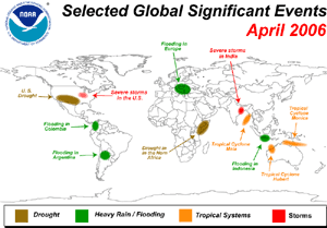
Heavy rain events and associated flooding occurred throughout April in Yemen, Colombia, Eastern Europe, northeastern Australia, Indonesia and northern Argentina. Flooding and landslides caused significant loss of life and property damage in many of these locations. Precipitation estimates for northwestern Colombia from March 1 to April 16 exceeded 27 inches (700 mm). In Eastern Europe in mid-April, the Danube River reached its highest level in 111 years. Cyclone Monica became the strongest tropical cyclone of 2006. It reached Category 5 on the Australian scale, with 135 knots (155 mph) sustained winds before weakening as it crossed over northeastern Australia. The tropical cyclone season in the Australian region has been near average with the development of 12 storms, two more than average. Although final assessments of tropical cyclone strength are continuing, it is thought that 25 percent of these storms reached Category 5 strength on the Australian scale.
|


 Top of Page