ICESat First Light Release: A Continuous View of Clouds
|
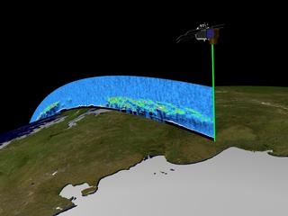
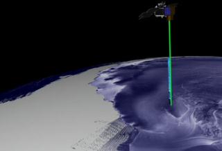
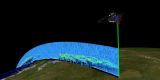
The GLAS laser system on ICESat is making unique measurements of the heights of clouds and their global distribution. In addition, ICESat can 'see' the distributions of aerosols from sources such as dust storms and forest fires. This animation shows the distribution of cloud layers as seens from the bird's eye perspective of the ICESat spacecraft.
|
|

|
|
Animation showing ICESat collecting cloud data.
Duration: 60.0 seconds
Available formats:
720x486 (29.97 fps)
Frames
352x240 (30 fps)
MPEG-1
8 MB
320x218
JPEG
6 KB
720x480 (29.97 fps)
DV
209 MB
How to play our movies
|
|
|
|
ICESat collecting cloud data
Available formats:
2560 x 1920
TIFF
4 MB
160 x 80
PNG
11 KB
320 x 240
JPEG
8 KB
80 x 40
PNG
3 KB
|
|

|
|
None
Available formats:
720 x 528
JPEG
94 KB
320 x 234
PNG
305 KB
|
| Animation Number: | 2744 |
| Animators: | Greg Shirah (Lead) |
| | Alex Kekesi |
| Studio: | NASA |
| Completed: | 2003-05-15 |
| Scientists: | Chris Shuman (NASA/GSFC) |
| | Jay Zwally (NASA/GSFC) |
| Instruments: | ICESat/GLAS
|
| | RADARSAT-1/SAR |
| | Terra/MODIS |
| Data set: | ICESat/GLAS Cloud Height Profile |
| Data Collected: | GLAS: 2003/03/02 |
| Video: | SVS2003-0015 * |
Keywords:
DLESE
>> Atmospheric science
SVS
>> Clouds
DLESE
>> Technology
|
|
Please give credit for this item to
NASA/Goddard Space Flight Center
Scientific Visualization Studio, Canadian Space Agency, RADARSAT International Inc. |
*Please note: the SVS does not fulfill requests for copies of the tapes in our library. On some of our animation pages, there is a direct link to a video distribution service from which tapes, handled by the Public Affairs Office (PAO)/Goddard TV, including some of our animations may be ordered. General information on this service can be found here. |
|
Back to Top
|

