

Images & Animations
-
Credit
NASA/JPL/NIMA
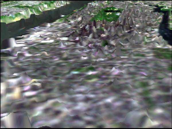
In this image of Manhattan, the city's skyscrapers appear as ghostly white spikes. The green patch in the middle of the image is Central Park. The Hudson River is visible on the upper left-hand side and the East River on the upper right. Although not designed to measure the heights of buildings, the radar used by the Shuttle Radar Topography Mission (SRTM) was so sensitive that it easily detected the Manhattan skyscrapers but could not distinguish individual structures.
The image was generated using topographic data from SRTM and enhanced true-color Landsat 5 satellite images. Topographic shading in the image was enhanced with false shading derived from the elevation model. Topographic expression is exaggerated 6X.
The elevation data used in this image was acquired by SRTM aboard the Space Shuttle Endeavour, launched on February 11, 2000. SRTM used the same radar instrument that comprised the Spaceborne Imaging Radar-C/X-Band Synthetic Aperture Radar (SIR-C/X-SAR) that flew twice on the Space Shuttle Endeavour in 1994. SRTM was designed to collect three-dimensional measurements of the Earth's land surface. To collect the 3-D SRTM data, engineers added a mast 60-meters (about 200-feet) long, installed additional C-band and X-band antennas, and improved tracking and navigation devices. The mission is a cooperative project between the National Aeronautics and Space Administration (NASA), the National Imagery and Mapping Agency (NIMA) of the U.S. Department of Defense (DoD), and the German and Italian space agencies. It is managed by NASA's Jet Propulsion Laboratory, Pasadena, CA, for NASA's Earth Science Enterprise, Washington, DC.
Size: scale varies in this perspective, Manhattan is about 3.5 km (2.2 miles) across.
Location: 40.8 deg. North lat., 74 deg. West lon.
Orientation: North toward the top
Image Data: Landsat bands 1, 2, 3, and 4
Metadata
-
Sensor
Space Shuttle/SRTM -
Visualization Date
2000-10-30