
|
|
.
|
Researching the effects of underwater hydrothermal venting systems |
 |
|
 |
|
 |
|
 |
|
 |
|
 |
|
|
| East Pacific Rise | ||
|
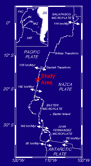
The southern East Pacific Rise (EPR) one of the fastest-spreading sections of the Earth's Mid-Ocean Ridge system. In 1993 and 1994 VENTS Program scientist participated in a series of research expeditions to the southern EPR with scientific collegues from from Japan, including the Geological Survey of Japan, JApanese Marine Science and TEchnology Center (JAMSTEC), University of Tokyo, the National Research Institute for Bioscience and Human Technology, and Tokai University, Hydrographic Dept. of the Marine Safety Agency, and the University of Tsukuba. The 1993 expedition was aboard the R/V Melville and was primarily focused on mapping and sampling of plumes in the water column from 13.5° S to 18.5°S. In 1994, two separate expeditions were mounted aboard the R/V Yokosuka with the Shinkai 6500 submersible. Fifteen dives were made on each leg to collect fluid, biological, and sulfides samples from vents sites, as well as geologic mapping and rock sampling.
updated 4/12/2001 |
||
 The
eastern equatorial Pacific has been monitored by
The
eastern equatorial Pacific has been monitored by