

 Climate Monitoring / Climate of 2006 / US summary / Snow Summary / Help Climate Monitoring / Climate of 2006 / US summary / Snow Summary / Help
Use these links to access detailed analyses of Global and U.S. data. 
|
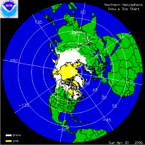 click here for animation |
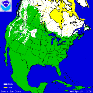 click here for animation |
|
The two satellite-derived animations above show the daily snow cover across the Northern Hemisphere (left map) and North America (right map) throughout April 2006. By clicking on the images, the change in sea-ice extent across parts of the Arctic can be seen through the month as well as several significant snowfall events across the U.S. and Europe, including a significant US northern Plains storm on the 18th-19th that dumped over 50 inches of snow locally in South Dakota.The seasonal retreat of snow cover can be seen in both animations as a record warm April in the U.S. and above average seasonal warmth across the Northern Hemisphere augmented the average seasonal snow cover extent decrease.
More information on significant winter weather and other hazards can be found on NCDC's Hazards page. |
 larger image Image courtesy of the USDA's Natural Resources Conservation Service |
The map to the left depicts percent of average snowpack in the West and Alaska as of May 1st. The snowpack is less than 50% of average across much of the Southwest region causing rising concern over spring water supply, which primarily results from melting snow. Abundant snowfall accumulated in parts of the Northwest through the winter and early spring, with abundant snowfall in the Sierra Nevada in early April. More information on April weather can also be found on NCDC's Hazards page, while information on the southwestern drought can be found on NCDC's monthly drought pages. |
 March
March
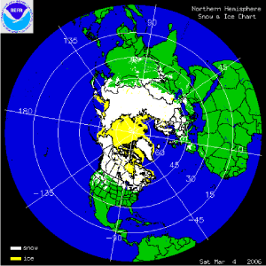 click here for animation |
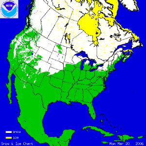 click here for animation |
|
The two satellite-derived animations above show the daily snow cover across the Northern Hemisphere (left map) and North America (right map) throughout March 2006. By clicking on the images, the change in sea-ice extent across parts of the Arctic can be seen through the month as well as several significant snowfall events across the U.S. and Europe, including a significant US central Plains storm on the 17th-20th. Sea-ice was the lowest on record for the Northern Hemisphere for March.
More information on significant winter weather and other hazards can be found on NCDC's Hazards page. |
 larger image Image courtesy of the USDA's Natural Resources Conservation Service |
The map to the left depicts percent of average snowpack in the West and Alaska as of April 1st. Despite significant March snowfall across the Southwest (see animated US snow cover map above right), the snowpack is less than 50% of average across much of the region causing rising concern over spring water supply, which primarily results from melting snow. Abundant snowfall accumulated in parts of the northwest through the winter and into March as Pacific storms impacted the region. More information on March winter weather can also be found on NCDC's Hazards page, while information on the southwestern drought can be found on NCDC's monthly drought pages. |
February
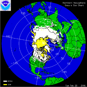 click here for animation |
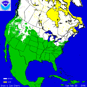 click here for animation |
|
The two satellite-derived animations above show the daily snow cover across the Northern Hemisphere (left map) and North America (right map) throughout February 2006. By clicking on the images, the change in sea-ice extent across parts of the Arctic can be seen through the month as well as several significant snowfall events across the U.S. and Europe, including a significant US East Coast storm on the 11th and 12th. February temperatures were near average for the US, while much warmer than average temperatures occurred in Alaska. Information on snow extent will be available later in the month. Sea-ice for the Great Lakes was still largely absent.
More information on significant winter weather and other hazards can be found on NCDC's Hazards page. |
 larger image Image courtesy of the USDA's Natural Resources Conservation Service |
The map to the left depicts percent of average snowpack in the West and Alaska as of March 1st. The snowpack is less than 50% of average across much of the Southwest causing rising concern over spring water supply, which primarily results from melting snow. Abundant snowfall accumulated in parts of the northwest through the winter as Pacific storms impacted the region during December and January. More information on February severe winter weather can also be found on NCDC's Hazards page. Alaska had mostly below average snowpack, partly as a result of warmer-than-average temperatures across the state during December and February and drier than average conditions in January. |
January
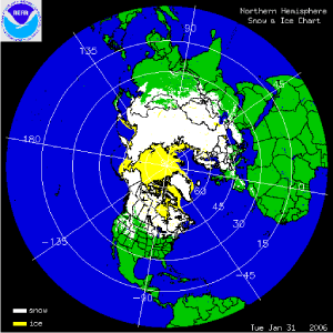 click here for animation |
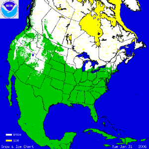 click here for animation |
|
The two satellite-derived animations above show the daily snow cover across the Northern Hemisphere (left map) and North America (right map) throughout January 2006. By clicking on the images, the change in sea-ice extent across parts of the Arctic (especially the Labrador Sea) can be seen through the month as well as several significant snowfall events across the U.S. and Europe. Exceptional warmth across much of the North American continent is reflected in a lack of snow cover for parts of the U.S. and lack of lake-ice across the Great Lakes, while colder than average temperatures led to snowier conditions over parts of Europe and western Asia. For the Arctic, the sea-ice extent was the lowest on record extending back to 1979.
More information on significant winter weather and other hazards can be found on NCDC's Hazards page. |
 larger image Image courtesy of the USDA's Natural Resources Conservation Service |
The map to the left depicts percent of average snowpack in the West and Alaska as of February 1st. The snowpack is less than 50% of average across much of the Southwest causing rising concern over spring water supply, which primarily results from melting snow. Abundant snowfall accumulated in parts of Oregon and southern Idaho as Pacific storms impacted the region during December and January. More information on January severe winter weather can also be found on NCDC's Hazards page. Alaska had below average snowpack, partly as a result of warmer-than-average temperatures across the state during December and drier than average conditions in January. |
| The map to the right depicts January sea-ice extent (in millions of square kilometers) across the Northern Hemisphere. For the past 2 years, January extent has been the lowest on record and is consistent with a general decreasing trend. For January 2006, sea-ice covered approximately 16.6 million sq km - an anomaly of 1.2 million sq km below the long-term (1979-2000) mean, reflecting the above average warmth across the region for the month. |
 larger image |
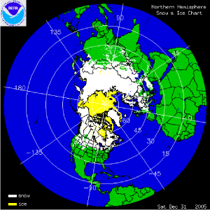
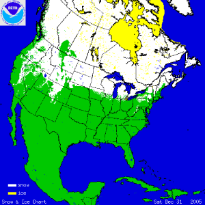
December
 click here for animation |
 click here for animation |
|
The two satellite-derived animations above show the daily snow cover across the Northern Hemisphere (left map) and North America (right map) throughout December 2005. By clicking on the images, the advance of sea-ice across Hudson Bay and parts of the Arctic can be seen through the month as well as several significant snowfall events across the U.S. and Europe.
More information on significant winter weather and other hazards can be found on NCDC's Hazards page. |
 larger image Image courtesy of the USDA's Natural Resources Conservation Service |
The map to the left depicts percent of average snowpack in the West and Alaska as of January 1st. The snowpack is less than 50% of average across much of the Southwest causing rising concern over spring water supply, which primarily results from melting snow. Abundant snowfall accumulated in parts of the southern Northwest as Pacific storms impacted the region during December. The storms produced mostly rain near the coast. More information on December severe winter weather can also be found on NCDC's Hazards page. Alaska had below average snowpack, partly as a result of warmer-than-average temperatures across the state during December. |
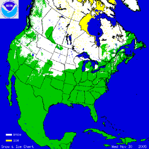
November
 click here for animation |
 click here for animation |
|
The two satellite-derived animations above show the daily snow cover across the Northern Hemisphere (left map) and North America (right map) throughout November 2005. The maps illustrate the advance of the snow pack in the northern latitudes. By clicking on the images, the gradual expansion of snow and ice cover is shown and by the end of the month, much of Siberia as well as Alaska and Canada are snow covered. Arctic sea-ice and Hudson Bay ice also increases throughout the month. Ice cover across the Great Lakes has yet to develop in 2005.
More information on significant winter weather and other hazards can be found on NCDC's Hazards page. |
 larger image Image courtesy of NOAA's National Operational Hydrologic Remote Sensing Center |
The map to the left depicts snow depth across the northern Great Plains on the 29th of November after a major winter storm swept across the region on the 27th/28th. Snow accumulation was well over a foot across a large area of the northern Plains while high wind gusts (in excess of 60 mph) led to blizzard conditions and widespread power outages. More information on November severe winter weather can also be found on NCDC's Hazards page. |
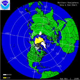
October
 click here for animation |
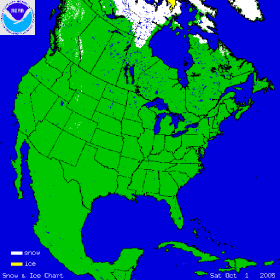 click here for animation |
|
The two satellite-derived images above show the daily snow cover across the Northern Hemisphere (left map) and North America (right map) throughout October 2005. The maps show snow cover on October 1st, illustrating the beginning of the snow pack in the northern latitudes. By clicking on the images, the gradual expansion of snow and ice cover is shown and by the end of the month, much of Siberia as well as Alaska and northern Canada are snow covered. Arctic sea-ice also increases throughout October. For the U.S., snow cover resulting from an early season snow event is shown in the northern Great Plains on October 6th, and in Colorado on October 11th. Billings, MT set a new record for daily October snowfall with nearly 10 inches on the 5th, while the greater Denver area in Colorado received over 10 inches on the 10th.
More information on significant winter weather and other hazards can be found on NCDC's Hazards page. |
 larger image Image courtesy of NOAA's National Operational Hydrologic Remote Sensing Center |
The map to the left depicts snow depth across the Northeast for the morning of October 26th, 2005. Snowfall associated with an early season Nor'easter and augmented by moisture from Hurricane Wilma several hundred miles off the coast, fell on October 25th, leaving over 6 inches of accumulation in some areas. The Nor'easter followed two storms earlier in the month that produced torrential rain causing localized flooding. In New Hampshire, Mount Washington's October snowfall record was shattered, with 78.9 inches falling in October 2005, compared with 39.8 inches in October 2000. More information on October severe winter weather can also be found on NCDC's Hazards page. |
Useful Links|
|
Questions?For all climate questions other than questions concerning this report, please contact the National Climatic Data Center's Climate Services Division:
| Climate Services Division NOAA/National Climatic Data Center 151 Patton Avenue Asheville, NC 28801-5001 fax: 828-271-4876 phone: 828-271-4800 email: questions@ncdc.noaa.gov |
For further information on the historical climate perspective presented in this report, contact:
|
Jay Lawrimore NOAA/National Climatic Data Center 151 Patton Avenue Asheville, NC 28801-5001 fax: 828-271-4328 email: Jay.Lawrimore@noaa.gov |
NCDC / Climate Monitoring / Climate of 2006 / Snow Summary / Help