|
||
|
|
||
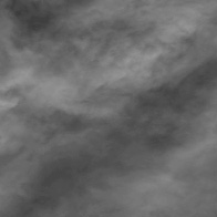
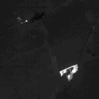
 Animation of all 50 MAS bands, from .547 µm to 14.17 µm. (2.4MB)
(All images & animations by Robert Simmon, with the gracious help of Pat Hrubiak, Goddard DAAC) |
NASA Demonstrates New Technology for Monitoring Fires from Space
—by David Herring May 29, 1998 Earth scientists at NASA's Goddard Space Flight Center recently demonstrated that the MODIS instrument, scheduled to launch in December 1999 on NASA's Earth Observing System Terra satellite, will have unprecedented abilities to detect forest fires anywhere on the surface of our planet. In two recent scientific papers, the scientists announce that MODIS (or Moderate-resolution Imaging Spectroradiometer) will measure the intensities of fires and will therefore enable them to detect active fires, accurately estimate rates of combustion, as well as the amounts of emission products—such as smoke, greenhouse gases, and aerosol particles—the fires produce.
According to the papers' principal authors, Drs. Yoram Kaufman, of NASA's Goddard Space Flight Center, and Chris Justice, University of Virginia, the new fire monitoring capability MODIS provides could greatly enhance our abilities to more efficiently manage natural resources and more effectively combat wild fires. Moreover, in concert with other space-based sensors, MODIS will enable scientists to assess the impacts fires may have on air quality near local communities, or even metropolitan areas. Kaufman, Terra project scientist, explains that due to MODIS' moderate (1-km) resolution, most fires will be too small to be seen by the sensor. Consequently, it will only detect about 25 percent of the fires burning worldwide. Yet, because those are the larger, more intense fires, they are responsible for 80 to 100 percent of the biomass burned. "This is an important point, because until recently, scientists didn't fully understand the relationships between the radiative energy a fire emits, its rate of combustion, and the resulting emission products," Kaufman states. Based upon the results from the 1995 "Smoke, Clouds and Radiation" (SCAR) campaign in Brazil, the authors conclude that "a fire's radiative energy output is highly correlated (97 percent) with the generation of the burn scar and therefore with the consumption of biomass." (SCAR was sponsored jointly by NASA and the government of Brazil.) Fires generally burn at temperatures anywhere from 500K to 1400K (440�F to 2060�F). Fires toward the higher end of this range become so hot they actually burn down into the soil, in addition to consuming plants, leeching the soil of its essential nutrients for sustaining life. Because MODIS is more sensitive to fires' temperatures than previous satellite remote sensors, scientists can better assess the damage they cause, as well as help fire fighters prioritize which fires are in most urgent need of fighting. "For individual wild fires," Kaufman continues, "the rate of combustion is an indicator of the strength and danger of a fire, and can be useful to firefighters in decisions on whether or not to fight the fire, as well as in developing a strategy for fire containment and suppression." Scientists will try to use the MODIS data to determine the phase of a given fire-whether it is flaming or smoldering (flaming combustion is the least polluting). Although the rate of combustion is higher during the flaming phase, more smoke, aerosol particles and greenhouse gases are emitted during the smoldering phase due to the lower combustion efficiency, which has the greatest influence on regional pollution and, potentially, on global climate change. Every year, the public media focuses on a number of unusually large fires burning in various parts of the world. In October 1997, smoke from the widespread burning in Indonesia covered a large portion of the Asia-Pacific region and was linked to a high number of health problems and some deaths in that country. From May through July 1998, more than 1,000 fires have burned in Southern Mexico and Central America, producing a cloud of smoke so dense and widespread that visibility in parts of southern Texas was reduced to 2 km. Some flights in that region were cancelled due to poor visibility and 53 counties were placed on a health advisory. "Most people are unaware how extensive fire is on our planet," observes Justice, lead scientist for the MODIS Land Discipline Group. "With increasing variability in weather events and climate, we're likely to see changes in fire frequency and extent and the associated disturbance to natural and managed ecosystems. For example, we have seen considerable interannual variability in fire occurrence in Brazil, Africa and the United States over the last few years. The occurrence of large fires near populated areas in California in recent years has caused considerable concern for state and local authorities and highlighted the need for improved fire management and monitoring." Co-author Darold Ward, of the U.S. Forestry Service, states that an estimated 6 petagrams (about 6.3 billion tons) of biomass are burned worldwide each year. He notes that about 80 percent of all biomass burning takes place in tropical countries. About 3 to 5 percent of the worldwide total—or 7 million acres—is burned annually here in the United States. "Approximately 2 to 5 million acres are burned by wild fires in the U.S. each year," Ward states, "while 5 million acres are burned as 'prescribed' fires, or fires that are beneficial in managing the ecosystems. Prescribed fires are deliberately planned and set by fire management officers for a variety of reasons." Forest managers often set prescribed fires to prepare a particular site for tree planting, as well as to kill undergrowth to reduce the competition from unwanted vegetation. Prescribed fires are used extensively for wildlife habitat improvements. Prescribed fires are also set and managed to reduce the potential hazard of larger, uncontrolled wild fire outbreaks. These fires reduce dead vegetation, or consume "fuel," that has accumulated on the forest floor. "In the western United States, forests have been well-protected from fire for the last 60-70 years," Ward explains. "These ecosystems that evolved in the presence of occasional 'natural' wild fires are now developing 'unnaturally' in competition with off-site species. Consequently, the forests have become unhealthy because of the large amount of dead and dying vegetation. This may lead to the spread of insects, disease, and to disastrous wildfires. "So, we recognize that fires are an important part of the ecosystem and we're trying to bring them back into the ecosystem in a responsible way," Ward concludes. "This requires fairly aggressive prescribed burning by land managers. We think MODIS data will be useful in helping us monitor their smoke output in light of air quality regulations. Additionally, through remote sensing, we can do a better job of assessing the impacts of fires in restoring the fire-dependent ecosystems." MODIS' advanced fire monitoring capabilities were first tested during the Smoke, Clouds and Radiation (SCAR) campaign held in Brazil in 1995. Jointly sponsored by NASA and the Brazilian government, SCAR was conducted by a team of government and university scientists from both nations. During the campaign, a MODIS Airborne Simulator was flown aboard NASA's ER-2 aircraft (a U-2 airplane modified for science use) at altitudes of up to 40,000 feet. The purpose of this simulator is to enable scientists to gather "MODIS-like" data so that they may refine their data processing techniques in anticipation of the launch of the real MODIS. According to Elaine Prins, co-author and research scientist with NOAA/NESDIS Office of Research and Applications, MODIS is an improvement upon previous satellite sensors due to its higher "saturation thresholds" as well as its larger number of spectal channels to better characterize the atmosphere and fires. By analogy, the sun is so bright that it quickly "saturates" a human eye when looked at directly. Similarly, remote sensors can become saturated when viewing hot, bright fires, rendering it impossible for them to distinguish important characteristics about that fire, such as its rate of combustion. "The primary fire detection channel on the AVHRR (Advanced Very High Resolution Radiometer) has a saturation threshold of approximately 320K," Prins states. "MODIS has four channels that are sensitive to fires. Two are located in the infrared portion of the electromagnetic spectrum at 4 and 11 microns with thresholds at 500K and 400K, respectively, and can be used to monitor fires day and night. The other two are located at 1.6 and 2.1 microns for nighttime fire detection." Once certain of its viewing pixels pass the "brightness temperature" test that identifies them as potential fires, the data are then run through a computer process to differentiate them from background pixels that are obviously not fire. Then, the 4-micron channel data are compared with data from MODIS' 11-micron channel to provide an additional perspective. The 4- and 11-micron channels were chosen because they are "window" channels that enable remote sensors to "see" more clearly through the atmosphere than most other channels. At night, MODIS can use its 1.6- and 2.1-micron channels for detecting fires, when data in these channels is acquired. NASA is planning two field campaigns in 1999 to test the accuracy of the MODIS fire product for Brazil and Southern Africa, two major fire regions of the World. According to the authors, MODIS data will also be applied in other useful and relevant ways. For instance, a fire potential product is being developed to indicate what regions are susceptible to wild fire outbreaks. Another co-author plans to use MODIS data to monitor volcanoes and, based upon sudden temperature increases, help forecast when a given volcano is about to erupt.
References Kaufman, Yoram J., Chris Justice, Luke Flynn, Jackie Kendall, Elaine Prins, Darold E. Ward, Paul Menzel, and Alberto Setzer, 1998: "Potential global fire monitoring from EOS-MODIS." Journal of Geophysical Research, 103, pp. 32,215-38. Kaufman, Yoram J., Richard G. Kleidmann, & Michael D. King, 1999: "SCAR-B fires in the tropics: Properties and remote sensing from EOS-MODIS." Journal of Geophysical Research, SCAR-B Special Issue, 103, pp. 31,955-68. The data used in this study are available in one or more of NASA's Earth Science Data Centers. |
|
Subscribe to the Earth Observatory About the Earth Observatory Contact Us Privacy Policy and Important Notices Responsible NASA Official: Lorraine A. Remer Webmaster: Goran Halusa We're a part of the Science Mission Directorate |