
The U.S. Geological Survey (USGS) deals with a wide range of natural hazards, such as earthquakes, floods, volcanic eruptions, landslides, coastal erosion, wildlife diseases, wildland fires, and geomagnetic storms. These unpreventable natural events inflict damage on people or property, costing the Nation $50 billion a year on average. The USGS documents where and how hazard events have occurred, to develop models that assist in disaster response and in mitigation planning. We also seek to develop better monitoring techniques and faster communication links to decision makers and to the general public, so that they get the information they need during these often fast-breaking events. This work involves extensive collaboration with other Federal agencies and with state and local officials, among others, to reduce loss of life and property damage.

Figure 1. Major flood events of 1997 (January through October). |
The largest events of 1997 have been a series of floods, both widespread river flooding and flash floods, that hit many different parts of the country (fig. 1). The storms also produced landslides, which imposed further heavy costs on these same regions. As if to highlight the vulnerability of our high-tech society to natural hazards, a geomagnetic storm that hit the earth's atmosphere in January destroyed the satellite used to transmit USGS earthquake data. Lastly, this year wildlife disease has emerged as a public issue. This new hazard is discussed in the companion 1997 Environment fact sheet. |
Floods
Flooding began on New Years Day in January 1997 over large parts of the states of Washington, Oregon, California, Nevada, and Idaho. Heavy snowstorms earlier in the season were followed at the turn of the year by unseasonably warm weather and heavy rains, resulting in catastrophically fast melting and runoff. Thirty-six deaths were attributed to the storms and subsequent floods, and thousands of people were evacuated (65,000 in northern California alone). Highways were washed out or blocked by landslides. Downtown Reno, Nev., was flooded, closing many of its 24-hour casinos for the first time ever, while Yosemite National Park was so hard hit that it was closed for months. Damages for California alone were estimated to be $1.6 billion, with damage in all states estimated at $3 billion.
Two months later, on February 28-March 2 of 1997, heavy thunderstorms produced widespread flooding in Kentucky and southern Ohio, along the Ohio River Valley. River levels rose quickly, causing 67 deaths and producing $1 billion in damage for the two states combined. Many communities experienced their worst flooding in 30 years, with some sites having river levels higher than the predicted 100-year-recurrence-interval flood. Flash flooding at Falmouth, Ky., downstream from a gaging station that was closed in 1994 for lack of funding, triggered public debate about the adequacy of the existing stream-gaging network.

|
Throughout these events, USGS scientists monitored river levels, even in hazardous circumstances (fig. 2), in order to provide a continuously updated flow of flood data to the National Weather Service (NWS), the U.S. Army Corps of Engineers (COE), and the Bureau of Reclamation, as well as to state and local emergency response officials. Where available, real-time river stage and discharge data were transmitted from gaging stations by satellite telemetry, allowing even faster information flow; this contributed to better flood forecasts, reservoir management, and evacuation plans to minimize loss of life and damage to property. USGS river stage information is provided at URL: http://water.usgs.gov/public/realtime.html. Figure 2. USGS worker hanging from cableway to make discharge measurement, June 1997. Photo by Randy Hayes, Idaho Falls, Idaho. |
Floods on the Red River of the North in April 1997 were anticipated months in advance because of record snowfalls in the northern Great Plains. However, the rapidity of the thaw, compounded by a late blizzard and hard freeze in early April, created worst-case conditions, both for the size of the flood, and for the USGS personnel monitoring it from ice-crusted bridges and river banks. Unforseen downstream channel conditions raised the flood crest above predicted levels, so that the river flooded all of Grand Forks, N.Dak., and East Grand Forks, Minn., forcing their nearly complete evacuation. In a further twist, part of the flooded downtown area in Grand Forks burned to the waterline, as firefighters were unable to reach fires in abandoned buildings (fig. 3). A crew of about 50 USGS workers, 22 of them from outside North Dakota, monitored what is now the flood of record for the region. Preliminary damage estimates are $2 billion, but the impact of this flood, both its financial and human costs, will linger for years.
|
The summer of 1997 brought the worst flash-flooding disasters in recent history in Colorado and Arizona (fig. 1). A thunder-storm stalled on the Rocky Mountain front west of Ft. Collins dumped 8-10 inches of rain into an area of less than 10 square miles in 24 hours. The resulting flash flood washed a freight train off its tracks, swept away several trailer parks, and killed five people. It burst through the basement wall of the library building at Colorado State University (CSU) and damaged or destroyed more than 425,000 volumes of material. Damage on the CSU campus alone is estimated at $125 million. As if to further demonstrate the hazard of flash flooding in the arid regions of the western United States, a series of flash floods in Arizona in the 4-day period from August 9 to 12 derailed an Amtrak train (injuring 100 people), flooded the Havasupai Indian Reservation (forcing the evacuation of hundreds of residents and tourists), and killed 12 hikers in a narrow slot canyon near Page, Ariz. These events strike so quickly and occur in such small watersheds that conventional precipitation and stream-gage monitoring offer only limited warning to vulnerable areas. However, rapid postevent surveys by USGS personnel, to flag high-water marks and to select sections for indirect measurements of flood discharges, allow us to document the size of the events and are essential to mitigation planning. |

Figure 3. Flood and fire damage in downtown Grand Forks, N. Dak. |
Landslides Follow Floods

Figure 4. The Woodway slide, Wash., with freight train crossing the lower part of the slide. |
The winter storms that spread devastation in the Pacific Northwest, Idaho, California, and Nevada were accompanied by landslides, debris flows, and abrupt ground subsidence that blocked or cut major highways throughout the region. One landslide, the Woodway slide (fig. 4) in the Puget Sound area, sent 10 cars from a Burlington-Northern freight train into Puget Sound. Landslide hazard evaluation in Washington and Oregon was done by USGS scientists, with the Federal Emergency Management Agency's (FEMA) support, in the wake of the 1996 winter storms. Those results, coupled with 1997's very similar experiences, have led to installation of a real-time monitoring site on the Woodway slide, which is still active and threatens the Rapid Transit Authority corridor between Seattle and Edmonds, Wash. Other response efforts included taking low-level air photographs of the many landslides to permit more detailed assessment of the slope instability hazards in this area. Further south, in the Sierra Nevada Mountains in California, an enormous landslide dammed the south fork of the American River and blocked U.S. Highway 50 for 4 weeks. Indirect costs alone of closing this major highway were estimated at $2 million per day. The slide is now monitored in real time by a prototype system that includes instruments reporting rainfall, pore pressure in the soil, and ground displacement. Information from both this and the Woodway slide site is on the web, and can be accessed at URL: http://landslides.usgs.gov/landslide.html or URL: http://www.usgs.gov/themes/landslid.html. |
Space Weather Affects Earthquake Program
Modern technology creates new vulnerabilities for society. Space weather, such as electromagnetic storms generated by solar flare activity, can seriously impair satellites and other communications and navigation systems. The USGS is one of four agencies in the Space Weather Program, along with NASA and NOAA (which make satellite observations), and the National Science Foundation (NSF). The USGS Geomagnetism Program is responsible for ground-based monitoring of this newly recognized hazard.
A very large eruption from the sun's corona on January 6, 1997, generated a huge, very intense cloud of plasma that surrounded and passed beyond the earth on January 10-11. The intense cloud of charged particles distorted the earth's magnetic field, disrupting satellite and other communications signals, especially in the polar regions. On January 11, the ATandT Telstar 401 communications satellite (original cost $200 million) failed and has been written off by ATandT as lost. Although most of the satellite's business had been U.S. domestic television transmission, it was also the carrier for the near real-time earthquake data for the USGS National Seismic Network. Until alternate satellite service was found, the USGS Earthquake Program was forced to slow its reporting of smaller quakes, though response times for larger ones were successfully maintained through the crisis.
The USGS efforts to reduce the losses to society from natural hazards involve extensive collaboration with other Federal agencies, with state and local governments, with the private sector, and even with foreign countries. The following stories highlight some of these cooperative activities. Another USGS cooperative activity, involving the use of satellite data to reduce wildfire hazards, is covered in the companion 1997 Information Management fact sheet.
New Networks in Southern California
The 1994 Northridge earthquake killed 57 people and caused damages that have been estimated to be as high as $40 billion. More earthquakes with that or greater impact can be expected in the greater Los Angeles area. To meet the threat to life and potentially devastating property losses, the USGS and others have set up two new monitoring networks: TriNet and SCIGN (fig. 5). TriNet, which is operated by the USGS, the California Institute of Technology, and the California Division of Mines and Geology, with major funding from FEMA, is an expanded and upgraded network of seismometers and strong-motion detectors. The Southern California Integrated Global Positioning System (GPS) Network (SCIGN), monitors deformation of the earth's surface. Partners in SCIGN include the Jet Propulsion Laboratory, the University of California at San Diego, and the USGS, with funding from the USGS, NASA, NSF, and the W.M. Keck Foundation. TriNet allows rapid determination of an earthquake's location and magnitude and of the distribution of strong ground motion for all felt earthquakes. This real-time and near-real-time information, broadcast to the California Office of Emergency Services and others, such as the local electric power companies, will allow faster and better response to earthquakes. SCIGN's tracking of ground deformation is of interest to all those responsible for the integrity of major engineered structures, such as dams, water reservoirs, aqueducts and pipelines, gas pipelines, bridges, and tall buildings.

Figure 5. Currently active stations for the
TriNet and SCIGN networks in the Los Angeles area.
Urban Multihazards Initiative
In October 1996, the USGS launched an initiative to assess the potential impact of natural hazards in urban areas. The first area of study is the urbanized, five-county region of southern Puget Sound, in Washington State. Potential hazards include earthquakes, floods, landslides, volcanic eruptions and debris flows, and tsunamis. The purposes of the initiative are to improve the underlying scientific data needed for hazard assessments, to develop integrated geographic information systems (GIS)-based displays of the information that allow multihazard assessments, and to demonstrate how loss estimates for major hazards can be used to develop mitigation options. The USGS is collaborating with FEMA, the Washington Department of Natural Resources, the University of Washington, several county and municipal governments, and the private sector.
As part of this project, in July 1997 a high-resolution aeromagnetic survey was carried out to detect faults concealed beneath the young sediments that blanket most of the Puget Sound area. The survey revealed the existence of many young faults; one of these, the Seattle fault (which runs through the city of Seattle and is suspected of having been the source of a magnitude 7.4 earthquake about 1,000 years ago), shows clearly in the aeromagnetic survey (fig. 6). Other products include a better method for estimating inundation areas for flooding rivers by using improved elevation data and GIS techniques, as well as a prototype digital geologic map of the region. The new geologic map and aeromagnetic data, coupled with liquefaction maps produced by the Washington Department of Natural Resources (DNR), will improve assessment of earthquake hazards in the Puget Sound area.

Figure 6. New aeromagnetic survey results and shaded-relief map for the Seattle area. Position of Seattle fault (white arrows) deviates in places from the previously mapped position (shown by dots)
Volcano Disaster Response Around the World
The Volcano Disaster Assistance Program (VDAP) is a cooperative effort between the USGS and the U.S. Agency for International Development's Office of Foreign Disaster Assistance to help reduce fatalities and economic losses in countries experiencing a volcanic crisis. Begun in 1986, this program includes a small core group of scientists from the Cascades Volcano Observatory and a cache of portable volcano-monitoring equipment ready for rapid deployment. When the U.S. State Department receives an official request from a country with a restless volcano, the VDAP crisis response team moves in, working with local scientists and technicians to set up a monitoring network and to provide timely information and analysis as the volcanic crisis develops.
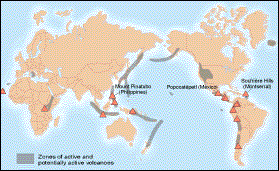
Figure 7. Volcanoes to which VDAP teams have been deployed.
VDAP has assisted at 15 volcanoes in a dozen countries (fig. 7). In 1991, accurate assessment of preeruptive seismicity at Mt. Pinatubo enabled VDAP scientists and their colleagues from the Philippine Institute of Volcanology to issue warnings that resulted in the safe evacuation of 75,000 people and the timely removal of hundreds of millions of dollars in military aircraft and hardware from U.S. military bases near the volcano. The unstable ash deposits left by the eruption have continued to wreak havoc in the area as runoff from rainstorms produces mudflows that block river channels and swamp fields and towns with wet, remobilized ash. VDAP is monitoring this stage of the disaster, to understand the longer-term impacts of the eruption. VDAP has also been called to help in the ongoing volcanic crises at Popocatepetl in Mexico and at the Soufriere Hills on the island of Montserrat in the British West Indies, deploying state-of-the-art monitoring networks around these two dangerous volcanoes, in collaboration with Mexican, Caribbean, and British scientists. Soufriere volcano on Montserrat has been the more active: as the lava dome in the main crater of the volcano has grown, it has sent avalanches of hot ash that have gradually destroyed the capital city of Plymouth, most of the land and villages on the southern part of the island, and the only airport on Montserrat. Popo poses the greater risk, however; looming over the surrounding area, the 17,887-foot-high volcano is visible to more than 20 million people and threatens 1 million who live within 20 miles of its summit. A major eruption would devastate the economy of Mexico. Either volcano has the potential to disrupt air traffic in the Caribbean, and so they both need to be monitored closely. VDAP's continued involvement, with equipment and advice, allows USGS scientists to gain valuable experience in different styles of volcanic activity and to share their experience for the benefit of people in Mexico and the Caribbean, citizens and travelers alike.
For information on these and other USGS products and services, call 1-800-USA-MAPS, or use the EARTHFAX fax-on-demand system, which is available 24 hours a day at 703-648-4888.
Please visit the USGS home page at URL: http://www.usgs.gov/
Explore the USGS Hazards Theme
Visit the previous Hazards Highlight

![]() U.S. Department of the Interior |
U.S. Geological Survey
U.S. Department of the Interior |
U.S. Geological Survey
URL: http://www.usgs.gov/themes/FS-188-97/index.html
Page Contact Information:
Ask USGS
Page Last Modified: 29-Jan-2003@15:01