U.S. Marine Cadastre
The U.S. Marine Cadastre is an information system, encompassing both the nature
and spatial extent of interests in property, value and use of marine areas.
Marine or maritime boundaries share a common element with their land-based
counterparts in that, in order to map a boundary, one must adequately
interpret the relevant law and its spatial context. Marine boundaries
are delimited, not demarcated, and generally there is no physical evidence
of the boundary. As a result, there can be confusion, disagreement, and
conflicting versions of marine boundaries. This Web site will serve as
a communication tool to assist Federal and State agencies in rectifying
these issues.
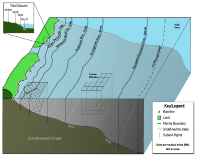
Maritime Zones: The boundaries
to these zones delimit the extent of a nation's sovereignty, exclusive
rights, jurisdiction and control over the maritime areas off its coast.
The boundaries may include a 12 nautical mile territorial sea, a 24
nautical mile contiguous zone, a 200 nautical mile Exclusive Economic
Zone and the continental shelf. The boundaries of the U.S. Maritime
Zones are depicted on official U.S. nautical charts produced and maintained
by the U.S. DOC National Oceanic and Atmospheric Administration (NOAA).
U.S. Seabed and Subsoil Boundaries:
Submerged Lands Act (SLA); Outer Continental Shelf Act (OCSLA): These
U.S. federal and state-level boundaries implement the Submerged Lands
Act (43 U.S.C. Sect. 1301 et seq. ) and the Outer Continental Shelf
Lands Act (43 U.S.C. Sect. 1331 et seq.)/ The U.S. DOI Minerals Management
Service (MMS) is the implementing agency for these Acts and the corresponding
boundaries.
Other U.S. Marine Boundaries:
U.S. boundaries in marine environment and interests that are Federal
as opposed to state are discussed here. Many U.S. agencies are involved
in the development and maintenance of these boundaries.
Depiction of U.S. Marine Boundaries: (Click on the image below to view the full graphic
and boundary explanations.)