 |
Virtual tour | ||||
|
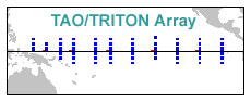
Scope and Relevance The TAO/TRITON Array, designed for the study of year-to-year climate variations related to El Nino and the Southern Oscillation (ENSO), consists of approximately 70 moored ocean buoys in the tropical Pacific Ocean. The array is supported by a multi-national partnership of institutions, and is a major component of global ocean and global climate observing systems. |
 |
| Scientists use oceanographic and meteorological data from the TAO/TRITON array for research into the causes of El Nino (ENSO warm events) and La Nina (ENSO cold events). The data also are fed into computer models that can predict the development of El Nino and La Nina up to one year in advance. |
|
ENSO
events significantly alter global weather patterns, affecting the lives
of millions around the world. They also affect Pacific marine ecosystems
and commercially valuable fish stocks such as tuna and anchovy. |
 Northern winter or summer |
||||||||
|
Instruments and operation The array consists of NOAA
TAO moorings in the eastern and central Pacific, and Japanese TRITON moorings
in the western Pacific. TAO/TRITON moorings measure surface meteorological
parameters, upper ocean temperatures and, at some locations, ocean currents.
NOAA's new research ship, the KA'IMIMOANA, is dedicated to servicing TAO
moorings, with an annual operating schedule of 250 days at sea. Significant
shiptime is
contributed by Japan to maintain TRITON moorings in the western Pacific. |
|
||||||||
|
Data display and access TAO/TRITON data can
be downloaded from the web or via anonymous FTP. Graphical dislays and
animations of the data are provided in a variety of formats to illustrate
the ever-changing environmental conditions in the tropical Pacific
|
 Last month's data Animated version |
||||||||
| Home | Project overview | Data display | Data delivery | El Niño & La Niña | Site map |
|
TAO
Project Office |

