www.srh.weather.gov
Home
News
Organization
Search
Local forecast by
"City, St" or Zip Code
Search by city or zip code. Press enter or select the go button to submit request
Search by city or zip code:
Current Hazards
Local Area Hazards
National Outlooks
Severe Weather
River Flooding
Current Conditions
Observations
Satellite Images
River Info
Rivers/Lakes AHPS
Radar Imagery
Regional Radar
Nationwide
Archived Radar
Forecasts
Local Area
Aviation
Marine Weather
Tide Info
Tropical Weather
Fire Weather
Numerical Models
Graphical Forecast
Surf Zone
Climate
Local
National
More...
Weather Safety
Storm Ready
Preparedness
Rip Currents
Other Information
Weather Research
Past Events
Educational
Weather Radio
Office Information
Office History
Related Links
Sunrise/Sunset
Weather Calculator
Contact Us
Email to
Webmaster
or call us at
(251) 633-6443
You are at:
NWS Home
�
SRH Home
�
WFO Mobile Home
� Marine Page
Marine Weather
A Mariner's Guide to Marine Weather Services
(PDF - You will need the
Adobe Acrobat Reader
to view this file)
Mariner’s Guide For Hurricane Awareness In The North Atlantic Basin
(PDF - You will need the
Adobe Acrobat Reader
to view this file)
Tide Forecasts and Observations
Mobile Bay PORTS®
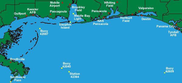
Marine Observations
Select station for last reported weather observation
(
Yellow
=buoy/cman
Red
=coastal land station/airport)
or click on links below
Click here for the Buoy/CMAN/Ship Marine Observation text product
Coastal Observations
Mobile Airport, AL
Brookley Field, AL
Pensacola Airport
NAS Pensacola, FL
Whiting Field, FL
Hurlburt Field, FL
Valparaiso, FL
Destin, FL
Panama City, FL
Tyndall AFB, FL
Pascagoula, MS
Keesler AFB, MS
Gulfport, MS
Boothville, LA
Buoy/CMAN Observations
Dauphin Island
Buoy 42007
Buoy 42040
Buoy 42039
Southwest Pass
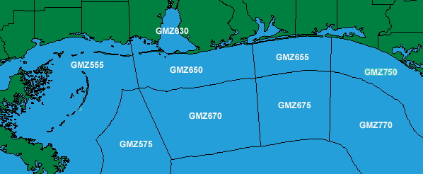
Western Gulf
Eastern Gulf
Marine Forecasts
Click on the map above or the links below to get the
latest five day marine forecast
(or click
here
for the full text product)
Mobile Bay
Apalachicola to Destin 20 to 60 NM out
Pensacola to Pascagoula out to 20 NM
Pascagoula to SW Pass out to 20 NM
Pensacola to Pascagoula 20 to 60 NM
Pascagoula to SW Pass 20 to 60 NM out
Destin to Pensacola out to 20 NM
Middle Gulf of Mexico beyond 60 NM
Destin to Pensacola 20 to 60 NM out
Eastern Gulf of Mexico beyond 60 NM
Apalachicola to Destin out to 20 NM
Other Marine Forecasts from the NWS
Marine MOS Products
GFS Marine MOS Forecast Guidance
GFS Text Messages By Station List
Eta/NAM Marine MOS Forecast Guidance
Eta/NAM Text Messages By Station List
Marine MOS Description
Marine MOS Buoy Station Table
Satellite and Radar Imagery
Offshore Visible (daytime) Satellite Picture
Gulf and Eastern States Infra-Red Satellite Picture
Gulf, Carribean, and Atlantic Visible Picture
Gulf, Carribean, and Atlantic Infra-Red Picture
Gulf, Carribean, and Atlantic Water Vapor Picture
Radar Links
Surf Zone Forecasts
From NWS Mobile
From NWS Tallahassee
Tide Information
Tide Forecasts and Observations for the
Alabama, Mississippi, and Florida Panhandle
Coastal Waters
Related Information
Tropical Cyclone Information
Sunrise/Sunset Times
Sea Surface Temperatures for the Gulf of Mexico
Other Links
National Buoy Data Center
Mariner's Weather Log
Lightning and Boats
National Safe Boating Council
Northern Gulf of Mexico Littoral Initiative
National Weather Service
Mobile/Pensacola Weather Forecast Office
8400 Airport Blvd Bldg 11
Mobile, AL 36608
(251) 633-6443
Web Master's E-mail:
sr-mob.webmaster@noaa.gov
Page last modified: April 17, 2008
Disclaimer
Credits
Glossary
Privacy Policy
About Us
Career Opportunities


