| |
|
2006 Fly-throughs: Ocean Explorer Return to the
Mariana Arc
Visit the volcanoes of the 2006 Jason
dives with a virtual fly-throughs. Higher resolution bathymetry
(EM300 and SeaBat) is viewed over bathymetry derived from satellite
altimetry data. (The satellite altimetry data are courtesy of Smith
and Sandwell, 1997.) Video image size is 480x360 pixels.
Fly-throughs
at a smaller size and additional volcanoes are available on the
Ocean
Explorer 2006 Ring of Fire website.
|
| |
|
|
| Virtual
Fly-throughs: |
 |
|
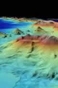
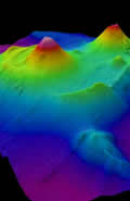
Fly-through from south to north along the Mariana Arc. Annotated volcanoes
were dive targets on the 2006 expedition. EM300 bathymetry data (higher
resolution top layer) was collected on the 2003 and 2004 Ring of Fire
expeditions. Data are 2Xs vertically exaggerated. Data set resolution
varies: EM300 bathymetry (35 meter grid), islands (30 meter grids),
and satellite (3500 meter grid). Island data (green) are from the
Shuttle Radar Topography Mission, courtesy of USGS and NASA.
Quicktime: 16.4
MB | Windows Media:
16.5 MB |
| |
|
|
 |
|
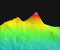
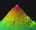
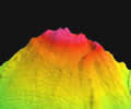
Daikoku
submarine volcano. Jason II dive target was the summit cone. Depths
range from 323 to 2763 meters (1059 to 9063 feet). The EM300 bathymetry
data are 2.5 times vertically exaggerated, with a resolution of ~25
meters.
Quicktime: 4.0
MB | Windows Media:
4.0 MB
See also: Daikoku
2006 video site |
| |
|
|
 |
|
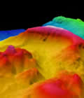
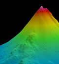
East
Diamante approached from the south/southwest, zooms inside the caldera
then down the north side of the edifice. Depths range from 136 to
2744 meters (446 to 9000 feet). The EM300 bathymetry data are 2.5
times vertically exaggerated, with a resolution of ~25 meters.
Quicktime: 4.0
MB | Windows Media:
4.1 MB
See also: East
Diamante 2006 video site |
| |
|
|
 |
|
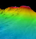
Esmeralda
Bank volcano, flying over the southwest flank and into the caldera.
Depths range from 54 to 2052 meters (177 to 6730 feet). Data are 2.5
times vertically exaggerated. EM300 bathymetry (25 meter resolution)
overlaid on SeaBat data (50 meter resolution). SeaBat data courtesy
of Yoshihiko Tamura, Jamstec, Japan.
Quicktime: 5.5
MB | Windows Media:
5.8 MB |
| |
|
|
 |
|
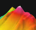
Nikko
submarine volcano, from the south and circling around the two summit
cones. The western cone is known to have an active hydrothermal system.
Depths range from 383 to 2705 meters (1256 to 8872 feet). The EM300
bathymetry data (~25 meter resolution) are overlaid on SeaBat data
(~50 meter resolution). Bathymetry data are 2.5 times vertically exaggerated.
SeaBat data are courtesy of Ko-ichi Nakamura, National Institute of
Advanced Science and Technology, Japan.
Quicktime: 4.4
MB | Windows Media:
4.4 MB
View: Nikko
2006 video site
|
| |
|
|
 |
|
NW
Eifuku submarine volcano, approached from the south. Depths range
from 1563 to 3396 meters (5127 to 11,139 feet). The EM300 bathymetry
data are 2.5 times vertically exaggerated, with a resolution of ~35
meters in these water depths.
Quicktime: 3.2
MB | Windows Media:
4.0 MB
View: NW Eifuku2006
video site |
| |
|
|
 |
|
NW
Rota-1 submarine volcano, approached from the south and circling the
summit. Depths range from 550 to 3400 meters (1804 to 11,152 feet).
The EM300 bathymetry data are 2.5 times vertically exaggerated, with
a resolution of ~30 meters in these water depths.
Quicktime: 5.9
MB | Windows Media:
7.2 MB
View: 2006 Brimstone
eruption and NW
Rota 1 Biology video sites |
| |
|
|
 |
|
Ruby
submarine volcano, approached from the southwest and circling the
summit. Depths range from 184 to 2955 meters (604 to 9692 feet). Ruby-2
is visible to the north of Ruby. The EM300 bathymetry data are 2.5
times vertically exaggerated, with a resolution of ~25 meters.
Quicktime: 5.0
MB | Windows Media:
5.9 MB |
| |
|
|
 |
|
Seamount-X
submarine volcano, approached from the southwest. Depths range from
1200 to 3800 meters (3936 to 12,464 feet). EM300 bathymetry data (~35
meter resolution at this water depth) are overlaid on MR1 data (100
meter grid-cell size). The data are 2.5 times vertically exaggerated.
Quicktime: 3.7
MB | Windows Media:
3.7 MB |
| |
|
|
Proper
Credits for the media:
Major funding for this expedition was provided by the following:
NOAA Ocean Exploration Program
NOAA Vents Program
All fly-throughs were created by Susan
Merle, Oregon State University/NOAA
Return to Vents Ring
of Fire site
Vents 2006 multimedia
site
To follow
these expeditions, visit:
 NOAA's Ocean
Explorer
NOAA's Ocean
Explorer
|
|