Skip all navigation and jump to content Jump to site navigation Jump to section navigation.
NASA Logo - Goddard Space Flight Center + Visit NASA.gov
HOME PROJECTS RESOURCES SEARCH MAP

+ Advanced Search
Home
Home
View Most Recently Released Imagery
View Gallery of Imagery: A topical collection of SVS Imagery
Search Imagery by the keywords assigned to it
Search Imagery by the instruments that supplied data for a visualization product
Search Imagery by the series of visualizations that have been produced
Search Imagery by the scientist providing the data used in a visualization product
Search Imagery by the animator that created the product
Search Imagery by the identification number assigned to the visualization product
See other search options
Learn about the SVS Image Server
  + About the Server
  + Animation List
  + How to Use the Server


  + RSS Feeds
blank image
Previous Animation
Next Animation
Bermuda High

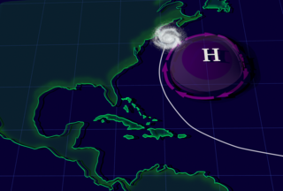
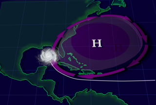
The Bermuda High pressure system sits over the Atlantic during summer. Acting as a block that hurricanes cannot penetrate, the size and location of this system can determine where hurricanes go. A normal Bermuda High often leads to hurricanes moving up the east coast and out to sea. During summer 2004 and 2005, the Bermuda High expanded to the south and west, which steered hurricanes into the Gulf of Mexico rather than up the east coast or curving out to sea. Once in the Gulf, most hurricane paths will involve landfall at some location.

The Bermuda High pressure system sits over the Atlantic during summer.   This  visualization first shows a typical Bermuda High system.  Then, it  expands the Bermuda High to show what happened in the summer of 2004 and 2005.    The Bermuda High pressure system sits over the Atlantic during summer. This visualization first shows a typical Bermuda High system. Then, it expands the Bermuda High to show what happened in the summer of 2004 and 2005.
Duration: 36.0 seconds
Available formats:
  3000x2025 TIFF         23 MB
  720x486     Frames
  320x216     PNG           70 KB
  150x101     PNG           24 KB
  75x50         PNG           13 KB
  720x480 (30 fps) MPEG-1   25 MB
  720x480 (29.97 fps) MPEG-2   18 MB
  1280x720   Frames
  720x486 (25 fps) MPEG-1   8 MB
  720x480 (29.97 fps) MPEG-2   8 MB
  720x480 (29.97 fps) MPEG-2   10 MB
  1280x720 (60 fps) MPEG-4   5 MB
  640x480 (29.97 fps) MPEG-4   5 MB
How to play our movies


During summer 2004 and 2005, the Bermuda High expanded to the south and west, which steered hurricanes into the Gulf of Mexico rather than up the east coast or curving out to sea.    During summer 2004 and 2005, the Bermuda High expanded to the south and west, which steered hurricanes into the Gulf of Mexico rather than up the east coast or curving out to sea.

Available formats:
  3000 x 2025     TIFF 23 MB
  320 x 216         PNG 73 KB

Animation Number:10069
Animator:Susan Twardy (Lead)
Studio:NASA
Completed:2006-06-07
Scientist:David Adamec (NASA/GSFC)
Series:Hurricanes
Keywords:
DLESE >> Atmospheric science
SVS >> HDTV
SVS >> Hurricane
DLESE >> Natural hazards
GCMD >> EARTH SCIENCE >> Atmosphere >> Atmospheric Phenomena >> Hurricanes
 
 
Please give credit for this item to
NASA/Goddard Space Flight Center Conceptual Images Lab


Back to Top

USA.gov logo - the U.S. Government's official Web portal. + Privacy Policy and Important Notices
+ Reproduction Guidelines
NASA NASA Official:
Content Contact:
Curator: