How LRO Will Find Safe Landing Sites on the Moon
|
|
The first attempt to land humans on the moon – Apollo 11 – was a triumph that almost ended in disaster. At just 400 feet from the lunar surface, with only about a minute's worth of fuel remaining, astronauts Neil Armstrong and Edwin 'Buzz' Aldrin saw that their ship's computer was taking them directly into a crater the size of a football field, strewn with SUV-sized boulders. They quickly took control from the computer, flew over the crater and touched down in a smoother area beyond, cutting the engine with just 30 seconds of fuel left. In general, good landing sites need to be level and free from large boulders that could damage or tip the spacecraft as it attempts to land. And it's up to LRO to make those landings as safe as possible. Astronauts will want to avoid places with steep slopes that could tip the spacecraft, so LRO includes a laser ranging system that will build an elevation map to show the contours of the polar surface. The instrument, called the Lunar Orbiter Laser Altimeter (LOLA), records the time it takes for a laser pulse to travel from the spacecraft to the lunar surface and back to calculate the height of the lunar terrain. After a year in orbit aboard LRO, LOLA will have created an elevation map of the polar regions that is accurate to within a half-meter (20 inches) vertically and 50 meters (about 160 feet) horizontally. LRO will also use data from another instrument that measures temperatures to double-check the safe zone map. Temperatures change more rapidly in areas with loose materials (lots of rocks). By analyzing how quickly temperatures change in potential landing zones, planners using the instrument, named Diviner, can rule out areas that appear smooth but actually are likely to be rocky. LRO also carries a pair of eagle-eyed cameras, called the Narrow Angle Cameras (NACs) which together can take images that reveal details as small as a half-meter (almost 20 inches) over swaths 10 kilometers (about 6.2 miles) wide. As LRO orbits over the poles, the moon rotates beneath the spacecraft, and the NACs will gradually build up a detailed picture of the region. It will be used to identify safe landing zones free of large boulders and craters, allowing astronauts to avoid surprises like Apollo 11. LRO is being assembled and managed by NASA Goddard, and is scheduled to be launched in early 2009. NASA plans to have astronauts back on the moon by 2020. As astronauts close in on a new landing site late in the next decade, they can thank NASA Goddard's small robot scout for showing the safest approach.
|
|
|
|
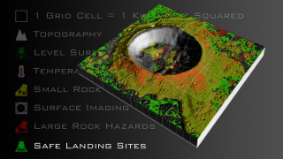
The crater depicted in this animation is ficticious and only intended for illustrative purposes. The animation begins with the reveal of a digital elevation map showing sample lunar topography illustrating the kind of data that LRO's LOLA instrument will collect. From this topographic data level surface areas can be derived as the first step to determining safe landing sites. Next, an example temperature map of the lunar surface is revealed to show the sort of data Diviner will collect. Changes in surface temperature will help determine small rock hazards, since they retain and release heat at a different rate than the surrounding regolith. Large rock hazards can be found with LROC's surface imagery. Finally, removing rock hazard areas from level surface areas reveals potential safe landing sites for future lunar missions.
Duration: 1.1 minutes
Available formats:
1920x1080 (30 fps)
MPEG-4
54 MB
1920x1080 (30 fps)
MPEG-2
205 MB
1280x720 (30 fps)
MPEG-4
51 MB
512x288 (30 fps)
MPEG-1
19 MB
1920x1080 (30 fps)
Frames (Full composition)
320x180
PNG
277 KB
160x80
PNG
64 KB
80x40
PNG
16 KB
How to play our movies
|
|

|
|
Animation of the crater itself without the text background. The raw frames provided have alpha channels, so this element can be overlaid over other visuals.
Duration: 1.1 minutes
Available formats:
1920x1080 (30 fps)
MPEG-2
173 MB
1280x720 (30 fps)
MPEG-4
50 MB
512x288 (30 fps)
MPEG-1
18 MB
1920x1080 (30 fps)
Frames (Just the crater)
320x180
PNG
109 KB
1920x1080 (30 fps)
MPEG-4
53 MB
How to play our movies
|
|

|
|
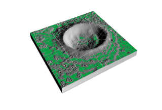
An artist rendition of topographic data being partially revealed to show a lunar crater. Similar topographic data will be taken by the LOLA instrument onboard LRO.
Available formats:
10800 x 7290
PNG
26 MB
5400 x 3645
PNG
7 MB
320 x 216
PNG
118 KB
|
|

|
|
An artist rendition showing topography of a lunar crater, as the LOLA instrument will eventually generate.
Available formats:
10800 x 7290
PNG
39 MB
5400 x 3645
PNG
10 MB
320 x 216
PNG
132 KB
|
|
|
|
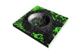
An artist rendition showing level surfaces in and around a lunar crater. Although such surfaces may be level, they may not be safe landing sites.
Available formats:
10800 x 7290
PNG
34 MB
5400 x 3645
PNG
9 MB
320 x 216
PNG
134 KB
|
|

|
|
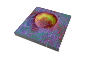
An artist rendition of Diviner's temperature data being laid over LOLA-like topography and a derived level surface product (depicted in green).
Available formats:
10800 x 7290
PNG
38 MB
5400 x 3645
PNG
10 MB
320 x 216
PNG
130 KB
|
|
|
|
An artist rendition of Diviner's temperature data over a lunar crater. Yellow and red indicate areas of high temperatures whereas purple and blue indicate areas with colder temperatures. The green areas depict areas with level surfaces.
Available formats:
10800 x 7290
PNG
34 MB
5400 x 3645
PNG
9 MB
320 x 216
PNG
133 KB
|
|
|
|
One of Diviner's derived products will be detection of small rock hazards. Since small rocks warm and cool slower than the surrounding regolith, Diviner's temperature data over time can reveal potential small rock hazards. This is an artist's rendition of the sort of small rock hazards that might be found around a lunar crater. Small rock hazards are shown in yellow.
Available formats:
10800 x 7290
PNG
41 MB
5400 x 3645
PNG
11 MB
320 x 216
PNG
125 KB
|
|
|
|
An artist rendition of LROC's imaging data being overlaid atop small rock hazards and level surfaces. The LROC camera will provide high resolution images of the lunar surface.
Available formats:
10800 x 7290
PNG
43 MB
5400 x 3645
PNG
12 MB
320 x 216
PNG
131 KB
|
|
|
|
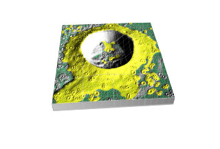
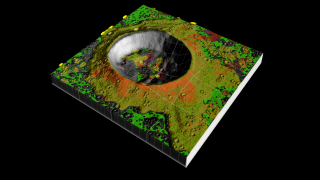
An artist rendition of LROC imaging data in shades of light to dark gray. Small rock hazards are shown in yellow. Level landing sites are shown in dark green.
Available formats:
10800 x 7290
PNG
41 MB
5400 x 3645
PNG
12 MB
320 x 216
PNG
134 KB
|
|

|
|
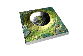
LROC's imaging cameras will provide highly detailed images of the lunar surface. From these images, scientists can determine where large rock hazards exist. Large rock hazards found in or near level surfaces will make landing in those areas unsafe.
Available formats:
10800 x 7290
PNG
42 MB
5400 x 3645
PNG
12 MB
320 x 216
PNG
135 KB
|
|
|
|
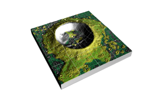
An artist rendition of safe landing sites around a fictional lunar crator. Safe landing sites are depicted in bright green.
Available formats:
10800 x 7290
PNG
34 MB
5400 x 3645
PNG
9 MB
320 x 216
PNG
138 KB
|
|
|
Back to Top
|

