Landsat Image Mosaic of Antarctica Flyover of McMurdo Station and Dry Valleys Without any Vertical Exaggeration
|
The Landsat Image Mosaic of Antarctica (LIMA) is a data product funded by the National Science Foundation (NSF) and jointly produced by the U.S. Geological Survey (USGS), the British Antarctic Survey (BAS), and the National Aeronautics and Space Administration (NASA). The LIMA data shown here uses the pan-chromatic band and has a resolution of 15 meters per pixel. The 13 swaths used to generate this sample mosaic where acquired between December 25, 1999 and December 31, 2001. The elevation data shown has no vertical exaggeration (1x) and is courtesy of the Radarsat Antarctic Mapping Project (RAMP) Digital Elevation Model (DEM).
|
|

|
|
This animation flys around Ross Island and the Dry Valleys of Antarctica highlighting the beautiful data provided by the LandSat Image Mosaic of Antarctica. There are no labels in this version.
Duration: 5.2 minutes
Available formats:
1280x720 (60 fps)
Frames
1280x720 (29.97 fps)
MPEG-4
75 MB
320x180
PNG
239 KB
1280x720 (30 fps)
Frames
How to play our movies
|
|

|
|
Full animation with labels - McMurdo Station is a science research center operated by the United States. New Zealand's science station, Scott Base, is located just 5 km away from McMurdo Station. Ross Island is surrounded by floating ice called the Ross Ice Shelf and the McMurdo Ice Shelf.
Duration: 5.2 minutes
Available formats:
1280x720
TIFF
1 MB
320x180
PNG
247 KB
160x80
PNG
61 KB
80x40
PNG
16 KB
1280x720 (29.97 fps)
MPEG-4
79 MB
1280x720 (60 fps)
Frames
720x480 (30 fps)
MPEG-1
130 MB
720x480 (30 fps)
MPEG-1
130 MB
640x360 (29.97 fps)
MPEG-4
25 MB
1280x720 (29.97 fps)
MPEG-4
43 MB
1280x720 (15 fps)
Frames
How to play our movies
|
|
|
|
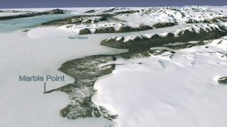
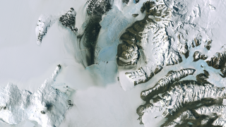
Across the McMurdo Sound lies Marble Point and New Harbor.
Available formats:
1280 x 720
TIFF
1 MB
320 x 180
PNG
272 KB
|
|

|
|
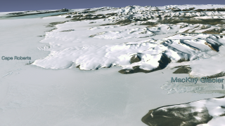
This image shows Cape Roberts and the MacKay Glacier.
Available formats:
1280 x 720
TIFF
1 MB
320 x 180
PNG
278 KB
|
|
|
|
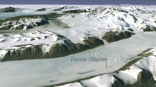
The Ferrar Glacier is located in between the Kukri Hills and the Royal Society Range.
Available formats:
1280 x 720
TIFF
1 MB
320 x 180
PNG
294 KB
|
|
|
|
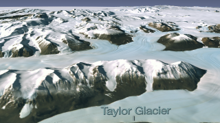
Taylor Glacier in front of the Kukri Hills.
Available formats:
1280 x 720
TIFF
1 MB
320 x 180
PNG
293 KB
|
|
|
|
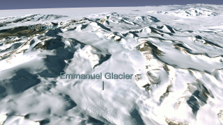
Fly up Emmanuel Glacier to Mt. Lister in the Royal Society Range.
Available formats:
1280 x 720
TIFF
1 MB
320 x 180
PNG
295 KB
|
|
|
|
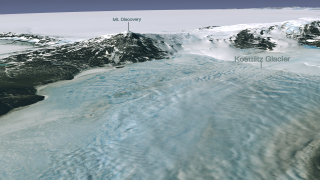
Fly down the Koettlitz Glacier and pass Mount Discovery along the way.
Available formats:
1280 x 720
TIFF
1 MB
320 x 180
PNG
282 KB
|
|
|
|
This view shows the region surrounding Mt. Erebus/McMurdo Station to the left and Antarctica's Dry Valleys to the right.
Available formats:
1280 x 720
TIFF
1 MB
320 x 180
PNG
299 KB
|
| Animation Number: | 3482 |
| Animators: | Lori Perkins (SVS) (Lead) |
| | Greg Shirah (SVS) |
| Completed: | 2007-11-26 |
| Scientist: | Bob Bindschadler (NASA/GSFC) |
| Instrument: | Landsat-7/ETM+ |
| Data set: | Landsat-7 Band Combination 3, 2, 1 |
| Data Collected: | LIMA: 12/25/1999 - 12/31/2001 |
| Series: | Landsat Image Mosaic of Antarctica |
Keywords:
SVS
>> HDTV
GCMD
>> EARTH SCIENCE
>> Cryosphere
>> Glaciers/Ice Sheets
GCMD
>> EARTH SCIENCE
>> Cryosphere
>> Glaciers/Ice Sheets
>> Glacier Elevation/Ice Sheet Elevation
GCMD
>> EARTH SCIENCE
>> Cryosphere
>> Glaciers/Ice Sheets
>> Glacier Topography/Ice Sheet Topography
GCMD
>> Location
>> Antarctica
|
This work has been visible on
1). The National Science Foundation (11/27/2007): 'Newly Unveiled Satellite Map of Antarctica is a Unique Tool for Scientists, Educators, and the Public' 2). MSNBC (11/27/2007) : 'Virtual Antarctica Revealed in High Definition' 3). BBC News (11/27/2007): 'White Continent in its Full GLory' 4). ABC News (11/27/2007): 'Antarctica in Hi-Def' 5). World Science (11/27/2007): 'New Antarctic Image Map to Revolutionize Research' 6). United Press International (11/27/2007): 'New Map of Antarctica is Published' 7). IT Wire (11/28/2007) : 'NASA sees Antarctica 10X more clearly than before' 8). Tech News World (11/28/2007): 'New Super MapMakes Antarctica Crystal Clear' 9). Fox News (11/28/2007): 'Scientists Unveil High-Definition Map of Antarctica' 10). The Great Beyond (11/28/2007): 'NASA's New Map of the Big White' 11). E-Flux Media (11/28/2007): 'Ultra-High Resolution Photo Map of Antarctica' 12). National Geographic News (11/28/2007): 'Photo in the News: Hi-Res Antarctic Map Unveiled' 13). Government Computer News (11/28/2007): 'Clearer View of Cold Continent' 14). WJZ TV Baltimore Video (11/29/2007): 'Coffee with NASA Scientist, Dr. Bob Bindschadler' 15). Voice of America (11/29/2007): 'Scientists Unveil High-Definition Map of Antarctica' 16). TV Week (11/29/2007): ' A High-Def Look at Antarctica' 17). Voice of America (11/30/2007): 'Website of the Week - Antarctica Mosaic' |
|
Please give credit for this item to
NASA/Goddard Space Flight Center Scientific Visualization Studio
LIMA Data provided by: Patricia Vornberger (SAIC)
LIMA data produced by U.S. Geological Survey (USGS), the British Antarctic Survey (BAS) and NASA |
|
Back to Top
|

