Skip all navigation and jump to content Jump to site navigation Jump to section navigation.
NASA Logo - Goddard Space Flight Center + Visit NASA.gov
HOME PROJECTS RESOURCES SEARCH MAP

+ Advanced Search
Home
Home
View Most Recently Released Imagery
View Gallery of Imagery: A topical collection of SVS Imagery
Search Imagery by the keywords assigned to it
Search Imagery by the instruments that supplied data for a visualization product
Search Imagery by the series of visualizations that have been produced
Search Imagery by the scientist providing the data used in a visualization product
Search Imagery by the animator that created the product
Search Imagery by the identification number assigned to the visualization product
See other search options
Learn about the SVS Image Server
  + About the Server
  + Animation List
  + How to Use the Server


  + RSS Feeds
blank image
Previous Animation
Next Animation
Fires in Greece as seen by Aqua/AIRS

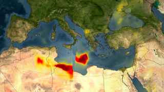
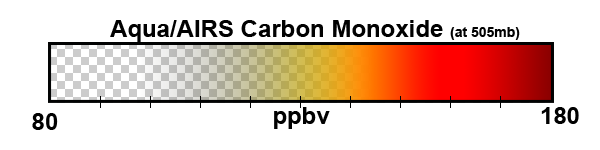
A series of fires across Greece in August of 2007 burned 469,000 acres and claimed the lives of 65 people. The fires, in which an estimated 4,000 people lost their homes, mostly occurred in the southern part of of the country.

In this visualization, the carbon monoxide signature from the fires in Greece is revealed in data retrieved by the Atmospheric Infrared Sounder (AIRS) on NASA's Aqua spacecraft. Forest fires create large amounts of carbon monoxide. AIRS provides daily global maps of carbon monoxide from space, allowing scientists to follow the global transport of this gas day-to-day. This visualization shows the amount of Carbon monoxide that has risen 2 to 8 kilometers (6,500 ft to 26,200 ft altitude) from August 24-28, 2007. More carbon monoxide generally means more pollution, either natural from wildfires or from industrial and domestic sources.

Beginning August 24, a significant plume emanates from the extensive fires burning in Greece. This plume moves southeast across the Mediterranean Sea and over North Africa from August 24 to 28. It crosses to Africa and arcs westward over the Sahara Desert and continues to curl around over the Eastern Mediterranean toward Sardinia and Corsica.


Carbon monoxide near Greece (with date labels)    Carbon monoxide near Greece (with date labels)
Duration: 12.0 seconds
Available formats:
  1280x720 (30 fps) MPEG-4   3 MB
  512x288 (30 fps) MPEG-1   3 MB
  640x360 (30 fps) MPEG-4   1 MB
  1280x720 (30 fps) MPEG-2   11 MB
  1280x720 (30 fps) Frames (Without labels)
  320x180     PNG           296 KB
How to play our movies


Carbon monoxide near Greece (without date labels)    Carbon monoxide near Greece (without date labels)
Duration: 12.0 seconds
Available formats:
  1280x720 (30 fps) MPEG-4   3 MB
  512x288 (30 fps) MPEG-1   3 MB
  640x360 (30 fps) MPEG-4   1 MB
  1280x720 (30 fps) MPEG-2   11 MB
  320x180     PNG           296 KB
  160x80       PNG           68 KB
  80x40         PNG           17 KB
  1280x720 (30 fps) Frames (With labels)
How to play our movies


Color bar for Aqua/AIRS CO in Greece
   Color bar for Aqua/AIRS CO in Greece

Available formats:
  600 x 150         PNG 16 KB

Animation Number:3449
Animator:Greg Shirah (SVS) (Lead)
Completed:2007-08-30
Scientists:Tom Pagano (NASA/JPL CalTech)
 Edward Olsen (NASA/JPL CalTech)
Instrument:Aqua/AIRS
Data set:Carbon Monoxide
Data Collected:2007/08/24 to 2007/08/28
Keywords:
SVS >> HDTV
DLESE >> Human geography
DLESE >> Natural hazards
GCMD >> EARTH SCIENCE >> Human Dimensions >> Natural Hazards >> Fires
SVS >> iPod
 
 
Please give credit for this item to
NASA/Goddard Space Flight Center Scientific Visualization Studio


Back to Top

USA.gov logo - the U.S. Government's official Web portal. + Privacy Policy and Important Notices
+ Reproduction Guidelines
NASA NASA Official:
SVS Contact:
Curator: