Skip all navigation and jump to content Jump to site navigation Jump to section navigation.
NASA Logo - Goddard Space Flight Center + Visit NASA.gov
HOME PROJECTS RESOURCES SEARCH MAP

+ Advanced Search
Home
Home
View Most Recently Released Imagery
View Gallery of Imagery: A topical collection of SVS Imagery
Search Imagery by the keywords assigned to it
Search Imagery by the instruments that supplied data for a visualization product
Search Imagery by the series of visualizations that have been produced
Search Imagery by the scientist providing the data used in a visualization product
Search Imagery by the animator that created the product
Search Imagery by the identification number assigned to the visualization product
See other search options
Learn about the SVS Image Server
  + About the Server
  + Animation List
  + How to Use the Server


  + RSS Feeds
blank image
Previous Animation
Next Animation
Sample LIMA Data versus MOA Data of Koettlitz Glacier

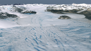
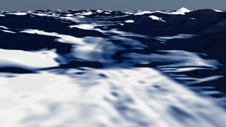
The Landsat Image Mosaic of Antarctica (LIMA) is a data product funded by the National Science Foundation (NSF) and jointly produced by the U.S. Geological Survey (USGS), the British Antarctic Survey (BAS), and the National Aeronautics and Space Administration (NASA). The images shown here are compared to what is currently the best mosaic of Antarctica called the MODIS Mosaic of Antarctica (MOA). MOA is a composite of 260 swaths comprised of both Terra and Aqua MODIS images acquired between November 20, 2003 and February 29, 2004. MOA's data resolution is approximately 150 meters per pixel. From large continental views of Antarctica, MOA is more than adequate. However, as we get closer in to the surface, the resolution of the MOA data begins to show, thus highlighting the value of the LIMA product once it is complete. The LIMA data shown here uses the pan-chromatic band which translates to a resolution of 15 meters per pixel (opposed to MOA's 150 meters per pixel resolution). The 13 swaths used to generate this sample mosaic where acquired between December 25, 1999 and December 31, 2001. The elevation shown is actual (1x). Comparing this sample LIMA data set alongside MOA data over the same region shows the value of having a higher resolution view of Antarctica.

This brief animation does a mosaic dissolve between the lower resolution MOA data of Koettlitz Glacier to the high resolution LIMA data of the same region.
   This brief animation does a mosaic dissolve between the lower resolution MOA data of Koettlitz Glacier to the high resolution LIMA data of the same region.
Duration: 3.0 seconds
Available formats:
  512x288 (60 fps) MPEG-1   1 MB
  1280x720 (59.94 fps) Frames
  320x180     PNG           285 KB
  1280x720 (60 fps) MPEG-2   1 MB
  1280x720 (59.94 fps) MPEG-4   1 MB
How to play our movies


Lower resolution MOA data (150 meters per pixel) of the same region centered over Koettlitz Glacier.    Lower resolution MOA data (150 meters per pixel) of the same region centered over Koettlitz Glacier.

Available formats:
  1280 x 720       TIFF 1 MB
  320 x 180         PNG 257 KB


High resolution LIMA data (15 meters per pixel) centered over Koettlitz Glacier.    High resolution LIMA data (15 meters per pixel) centered over Koettlitz Glacier.

Available formats:
  1280 x 720       TIFF 2 MB
  320 x 180         PNG 285 KB
  160 x 80           PNG 67 KB
  80 x 40             PNG 17 KB

Animation Number:3415
Animator:Alex Kekesi (SVS) (Lead)
Completed:2007-03-01
Scientist:Bob Bindschadler (NASA/GSFC)
Instruments:Aqua/MODIS
 Landsat-7/ETM+
 Terra/MODIS
Data sets:MODIS Global Reflectance
 Landsat-7 Band Combination 3, 2, 1
Data Collected:MOA: 11/20/2003 - 2/29/2004; LIMA: 12/25/1999 - 12/31/2001
Series:Landsat Image Mosaic of Antarctica
Keywords:
SVS >> HDTV
GCMD >> EARTH SCIENCE >> Cryosphere >> Glaciers/Ice Sheets
GCMD >> EARTH SCIENCE >> Cryosphere >> Glaciers/Ice Sheets >> Glacier Elevation/Ice Sheet Elevation
GCMD >> EARTH SCIENCE >> Cryosphere >> Glaciers/Ice Sheets >> Glacier Topography/Ice Sheet Topography
GCMD >> Location >> Antarctica
 
 
Please give credit for this item to
NASA/Goddard Space Flight Center Scientific Visualization Studio

LIMA Data provided by: Patricia Vornberger (SAIC)


Back to Top

USA.gov logo - the U.S. Government's official Web portal. + Privacy Policy and Important Notices
+ Reproduction Guidelines
NASA NASA Official:
SVS Contact:
Curator: