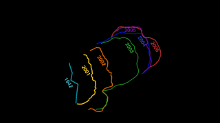
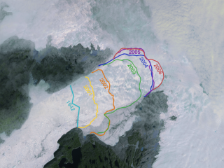
Jakobshavn Glacier Flow in the year 2000 and Calving Front Retreat from 2001 to 2006
|
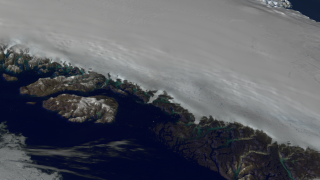
Since measurements of Jakobshavn Isbrae were first taken in 1850, the glacier has gradually receded, finally coming to rest at a certain point for the past 5 decades. However, from 1997 to 2006, the glacier has begun to recede again, this time almost doubling in speed. The finding is important for many reasons. As more ice moves from glaciers on land into the ocean, it raises sea levels. Jakobshavn Isbrae is Greenland's largest outlet glacier, draining 6.5 percent of Greenland's ice sheet area. The ice stream's speed-up and near-doubling of ice flow from land into the ocean has increased the rate of sea level rise by about .06 millimeters (about .002 inches) per year, or roughly 4 percent of the 20th century rate of sea level increase. This animation shows the glacier's flow in 2000, along with changes in the glacier's calving front between 2001 and 2006.
|
|

|
|
This animation shows the flow of the Jakobshavn glacier in 2000, followed by a time series of the glacier's retreat from 2001 through 2006. A colored line and date marks the position of the glacier's calving front each year.
Duration: 34.0 seconds
Available formats:
1280x720 (29.97 fps)
Frames (GlacierWoverlay)
320x180
PNG
72 KB
160x80
PNG
18 KB
80x40
PNG
5 KB
512x288 (30 fps)
MPEG-1
8 MB
720x480 (29.97 fps)
MPEG-2
22 MB
1280x720 (29.97 fps)
MPEG-2
71 MB
1280x720 (29.97 fps)
MPEG-4
31 MB
How to play our movies
|
|
|
|
This element contains the Jakobshavn glacier retreat without calving front positions and without dates.
Duration: 34.0 seconds
Available formats:
1280x720 (29.97 fps)
Frames (Glacier)
320x180
PNG
89 KB
720x480 (29.97 fps)
MPEG-2
19 MB
1280x720 (29.97 fps)
MPEG-2
71 MB
1280x720 (29.97 fps)
MPEG-4
31 MB
512x288 (29.97 fps)
MPEG-1
8 MB
How to play our movies
|
|
|
|
This element contains the overlay of the glacier's calving front positions and dates.
Available formats:
1280x720 (29.97 fps)
Frames (Overlay)
320x180
PNG
10 KB
How to play our movies
|
|
|
|
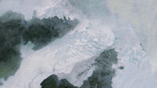
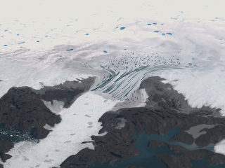
This still image shows the glacier ice flow vectors in the year 2000.
Available formats:
2560 x 1920
TIFF
5 MB
320 x 240
PNG
107 KB
|
|
|
|
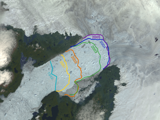
This still image shows the calving front on 07/02/2005. Lines also indicate the calving front in 1942, and 2001 through 2005.
Available formats:
2560 x 1920
TIFF
13 MB
320 x 240
PNG
135 KB
|
|
|
|
This still image shows the calving front on 08/08/2006. Lines also indicate the calving front in 1942, and 2001 through 2006.
Available formats:
2560 x 1920
TIFF
12 MB
320 x 240
PNG
123 KB
|
| Animation Number: | 3374 |
| Animators: | Cindy Starr (SVS) (Lead) |
| | Greg Shirah (SVS) |
| | Alex Kekesi (SVS) |
| | Stuart A. Snodgrass (SVS) |
| Completed: | 2006-09-12 |
| Scientists: | Waleed Abdalati (NASA/HQ) |
| | Richard Alley (Pennsylvania State University) |
| | Serdar Manizade (NASA/GSFC Wallops) |
| | Konrad Steffan (University of Colorado) |
| | Gordon Hamilton (University of Maine) |
| Instruments: | Landsat-7/ETM+
|
| | Terra/ASTER |
| Data sets: | Landsat-7 Band Combination 3, 2, 1
|
| | ASTER Band Combination 3, 2, 1 |
| Data Collected: | MODIS imagery of Greenland (06/25/2003), Landsat Imagery (07/07/2001, 09/03/2002, 08/23/2003, 10/03/2004), ASTER Imagery(07/02/2005, 08/08/2006), MODIS Blue Marble Landcover |
| Series: | NASM2006 |
| Goddard TV Tape: | G2007-001HD -- NASA's HD Climate Change Resource Tape |
Keywords:
DLESE
>> Cryology
SVS
>> Glacier
SVS
>> HDTV
GCMD
>> EARTH SCIENCE
>> Cryosphere
GCMD
>> EARTH SCIENCE
>> Hydrosphere
>> Snow/Ice
GCMD
>> EARTH SCIENCE
>> Cryosphere
>> Glaciers/Ice Sheets
>> Glacier Motion/Ice Sheet Motion
GCMD
>> EARTH SCIENCE
>> Cryosphere
>> Glaciers/Ice Sheets
>> Glaciers
GCMD
>> EARTH SCIENCE
>> Cryosphere
>> Sea Ice
>> Ice Floes
GCMD
>> EARTH SCIENCE
>> Cryosphere
>> Sea Ice
>> Ice Growth/Melt
GCMD
>> EARTH SCIENCE
>> Cryosphere
>> Sea Ice
>> Sea Ice Motion
GCMD
>> EARTH SCIENCE
>> Cryosphere
>> Snow/Ice
>> Freeze/Thaw
GCMD
>> EARTH SCIENCE
>> Cryosphere
>> Snow/Ice
>> Ice Motion
GCMD
>> EARTH SCIENCE
>> Hydrosphere
>> Snow/Ice
>> Ice Motion
GCMD
>> EARTH SCIENCE
>> Oceans
>> Sea Ice
>> Ice Extent
|
|
Please give credit for this item to
NASA/Goddard Space Flight Center Scientific Visualization Studio
The Blue Marble data is courtesy of Reto Stockli (NASA/GSFC).
Jeffrey E. Schmaltz (NASA/SSAI) |
|
Back to Top
|

