Hurricane Katrina Hot Towers
|
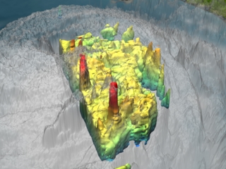
NASA's TRMM spacecraft allows us to look under Hurricane Katrina's clouds to see the rain structure on August 28, 2005 at 0324Z. Spikes in the rain structure known as 'hot towers' indicate storm intensity. 'Hot Towers' refers to tall cumulonimbus clouds and has been seen as one of the mechanisms by which the intensity of a tropical cyclone is maintained. Because of the size (1-20 km) and short duration (30 minute to 2 hours) of these hot towers, studies of these events have been limited to descriptive studies from aircraft observations, although a few have attempted to use the presence of hot towers in a predictive capacity. Before TRMM, no data set existed that could show globally and definitively the presence of these hot towers in cyclone systems. Aircraft radar studies of individual storms lack global coverage. Global microwave or Infrared sensor observations do not provide the needed spatial resolution. With a ground resolution of 5 km, the TRMM Precipitation Radar provided the needed data set for examining the predictive value of hot towers in cyclone intensification.
|
|
|
|
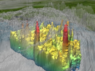
Energy-releasing deep convective clouds (to 16 km) in the eyewall of Hurricane Katrina on August 28 occurred while the storm was intensifying to a category 5 classification.
Duration: 20.0 seconds
Available formats:
720x480 (29.97 fps)
MPEG-2
10 MB
2560x1920
TIFF
5 MB
720x486 (30 fps)
Frames
320x240
JPEG
60 KB
160x80
PNG
27 KB
80x40
PNG
7 KB
1280x720 (29.97 fps)
MPEG-2
44 MB
1280x720 (30 fps)
Frames
320x240 (29.97 fps)
MPEG-1
2 MB
640x480 (29.97 fps)
MPEG-1
8 MB
How to play our movies
|
|
|
|
TRMM is the only satellite that can provide rain structure information over open oceans. Most tropical cyclones breed and intensify in these locations.
Available formats:
2560 x 1920
TIFF
5 MB
320 x 240
JPEG
62 KB
160 x 80
PNG
26 KB
80 x 40
PNG
7 KB
|
|
|
|
Two deep towers are observed by the TRMM spacecraft. The tower in the center is located in the hurricane's eye wall.
Available formats:
1280 x 720
TIFF
1 MB
320 x 180
JPEG
51 KB
160 x 80
PNG
26 KB
80 x 40
PNG
7 KB
|
|
|
|
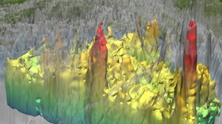
This image is the same as the above image with the clouds completely removed
Available formats:
1280 x 720
TIFF
1 MB
320 x 180
JPEG
50 KB
160 x 80
PNG
25 KB
80 x 40
PNG
7 KB
|
|
|
|
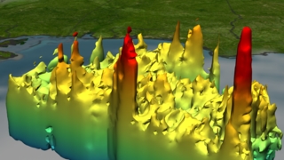
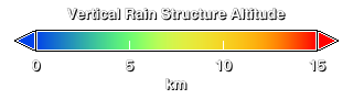
Hurricane Katrina's vertical rain structure in kilometers. The high towers are shown in red.
Available formats:
320 x 90
PNG
838 B
|
|
|
Back to Top
|

