AIRS Volumetric Cloud Data (Fly In)
|
This visualization shows Aqua/AIRS simulated volumetric cloud data for September 13, 1999. The data was created using the Finite Volume Community Climate Model (FVCCM). Temperature and cloud data sets were match rendered for cross dissolves in post production. This visualization was created as a part of the Aqua prelaunch package.
|
|
|
|
Fly in through cloud data
Duration: 29.0 seconds
Available formats:
1280x720 (30 fps)
MPEG-2
63 MB
352x240 (29.97 fps)
MPEG-1
3 MB
320x238
JPEG
11 KB
1280x720
Frames
720x480 (29.97 fps)
DV
108 MB
How to play our movies
|
|

|
|
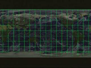
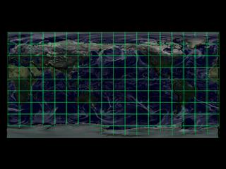
Volumetric global clouds on flat map (top view)
Available formats:
2560 x 1920
TIFF
4 MB
160 x 80
PNG
25 KB
320 x 240
JPEG
12 KB
80 x 40
PNG
7 KB
|
|
|
|
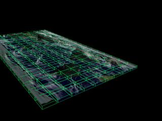
Volumetric global clouds on flat map (45 degree angle view)
Available formats:
2560 x 1920
TIFF
4 MB
320 x 240
JPEG
9 KB
|
|
|
|
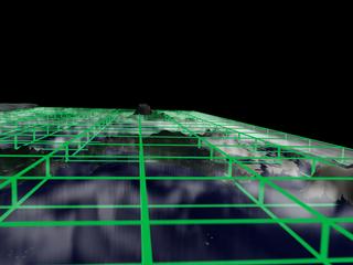
Volumetric global clouds on flat map (side view)
Available formats:
2560 x 1920
TIFF
3 MB
320 x 240
JPEG
10 KB
|
|

|
|
Volumetric global clouds on flat map (internal view)
Available formats:
2560 x 1920
TIFF
3 MB
320 x 240
JPEG
7 KB
|
|

|
|
None
Available formats:
720 x 528
JPEG
120 KB
320 x 234
PNG
291 KB
|
| Animation Number: | 2413 |
| Animators: | Greg Shirah (SVS) (Lead) |
| | Randall Jones (SVS) |
| | Horace Mitchell (SVS) |
| Completed: | 2002-03-14 |
| Scientist: | Claire Parkinson (NASA/GSFC) |
| Instruments: | Aqua/AIRS
|
| | Terra/MODIS |
| Data sets: | FVCCM: simulated volumetric clouds
|
| | FVCCM: simulated volumetric temperature |
| | MODIS Global Reflectance |
| Data Collected: | 1999/09/13 |
| Series: | Aqua Prelaunch |
| Video: | SVS2002-0015 * |
| Goddard TV Tape: | G2002-017 |
Keywords:
DLESE
>> Atmospheric science
SVS
>> Clouds
SVS
>> HDTV
SVS
>> Temperature
SVS
>> Volume
|
|
Please give credit for this item to
NASA/Goddard Space Flight Center
Scientific Visualization Studio |
*Please note: the SVS does not fulfill requests for copies of the tapes in our library. On some of our animation pages, there is a direct link to a video distribution service from which tapes, handled by the Public Affairs Office (PAO)/Goddard TV, including some of our animations may be ordered. General information on this service can be found here. |
|
Back to Top
|

