Skip all navigation and jump to content Jump to site navigation Jump to section navigation.
NASA Logo - Goddard Space Flight Center + Visit NASA.gov
HOME PROJECTS RESOURCES SEARCH MAP

+ Advanced Search
Home
Home
View Most Recently Released Imagery
View Gallery of Imagery: A topical collection of SVS Imagery
Search Imagery by the keywords assigned to it
Search Imagery by the instruments that supplied data for a visualization product
Search Imagery by the series of visualizations that have been produced
Search Imagery by the scientist providing the data used in a visualization product
Search Imagery by the animator that created the product
Search Imagery by the identification number assigned to the visualization product
See other search options
Learn about the SVS Image Server
  + About the Server
  + Animation List
  + How to Use the Server


  + RSS Feeds
blank image
Previous Animation
Next Animation
Deforestation of Rondonia, Brazil (with dates), from 1975 to 2001

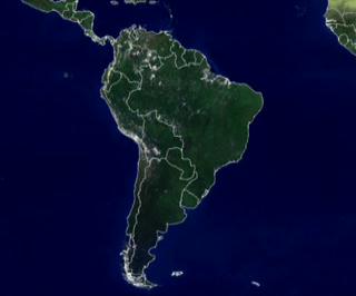
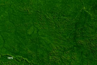
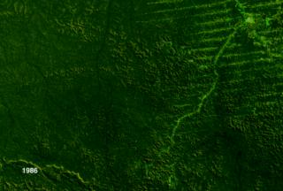
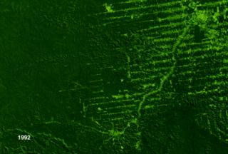
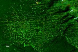
Throughout much of the 1980s, deforestation in Brazil eliminated more than 15,000 square kilometers (9000 square miles) per year. That pace has only increased through the 90s and into the 21st century.

Brazil is also home to more than a quarter of Earth's tropical forests. Considering that the band of lush green that circles the globe through many equatorial nations is fundamental to the overall health of the whole planet's environment, careful monitoring of forest health in the tropics is essential. Tropical forests act as major carbon 'sinks', places where ambient carbon dioxide in the atmosphere can be absorbed by growing things and sequestered for years. Definitive evidence shows that excess carbon dioxide can contribute to the greenhouse effect and speed global warming. Similarly, tropical forests also act as a primary

producer of oxygen. In the respiration process that absorbs gaseous carbon dioxide, trees and other plants give off oxygen.

It is for these and a host of other reasons why scientists and policy makers need to monitor and forestall wholesale deforestation.

This sequence shows how profligate clear cutting can influence that trust. Data gathered over time by several in the Landsat series of spacecraft shows enormous tracts of forest disappearing in Rondonia, Brazil. This territory underwent an enormous rise in population towards the end of the twentieth century, buoyed by cheap land offered by the national government for agricultural use. As you see the visualization progress, it is useful to note how the human phenomenon of deforestation generally works, especially in the dense tropical forests of Brazil. Systematic cutting of a road opens new territory to potential deforestation by penetrating into new areas. Clearing of vegetation along the sides of those roads tends to fan out to create a pattern akin to a fish skeleton. As new paths appear in the woods, new areas become vulnerable. The spaces between the 'skeletal bones' fall to defoliation, and another inch of the Earth's biological rudder is no longer reliably steering the planet into the future.


Showing changes in Rondonia, Brazil, due to deforestation.  Data from 1975, 1986, 1992, and 2001 is presented.    Showing changes in Rondonia, Brazil, due to deforestation. Data from 1975, 1986, 1992, and 2001 is presented.
Duration: 21.0 seconds
Available formats:
  1280x720 (30 fps) Frames
  1280x720 (30 fps) MPEG-2   46 MB
  320x240 (30 fps) MPEG-1   2 MB
  320x266     JPEG         7 KB
  160x80       PNG           13 KB
  320x266     JPEG         7 KB
  80x40         PNG           4 KB
  720x480 (29.97 fps) DV             79 MB
How to play our movies


1975 Image of Rondonia    1975 Image of Rondonia

Available formats:
  2880 x 1944     TIFF 9 MB
  320 x 216         JPEG 13 KB


1986 Image of Rondonia    1986 Image of Rondonia

Available formats:
  2880 x 1944     TIFF 8 MB
  320 x 216         JPEG 12 KB


1992 Image of Rondonia    1992 Image of Rondonia

Available formats:
  2880 x 1944     TIFF 9 MB
  320 x 216         JPEG 13 KB


2001 Image of Rondonia    2001 Image of Rondonia

Available formats:
  2880 x 1944     TIFF 6 MB
  320 x 216         JPEG 15 KB

Animation Number:2116
Animator:Joycelyn Thomson (SVS) (Lead)
Completed:2001-04-12
Scientist:Darrel Williams (NASA/GSFC)
Instruments:Landsat-2/MSS
 Landsat-4/TM
 Landsat-7/ETM+
 Landsat-5/MSS
Data Collected:1975/06/16, 1986/08/01, 1992/06/22, 2001/02/07
Series:Geophysical Changes Over Time
Video:SVS2001-0013 *
Goddard TV Tape:G2008-041HD -- NASAs Landsat in HD 2008 Resource Tape
Keywords:
DLESE >> Agricultural science
DLESE >> Environmental science
DLESE >> Forestry
SVS >> HDTV
SVS >> Rondonia
GCMD >> EARTH SCIENCE >> Human Dimensions >> Habitat Conversion/Fragmentation >> Deforestation
GCMD >> Location >> Brazil
More Information on this topic available at:
stories/earthday2001/index.html
 
 
Please give credit for this item to
NASA/Goddard Space Flight Center
Scientific Visualization Studio


*Please note: the SVS does not fulfill requests for copies of the tapes in our library. On some of our animation pages, there is a direct link to a video distribution service from which tapes, handled by the Public Affairs Office (PAO)/Goddard TV, including some of our animations may be ordered. General information on this service can be found here.


Back to Top

USA.gov logo - the U.S. Government's official Web portal. + Privacy Policy and Important Notices
+ Reproduction Guidelines
NASA NASA Official:
SVS Contact:
Curator: