|
|
 |
Mars Flyover Based on MOLA Data for the Carl Sagan Lecture
|
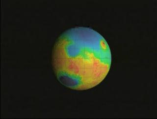
This visualization of the topography of Mars was created for Maria Zuber's Carl Sagan Lecture. The camera flies over several areas of interest. The south pole, Tharsis Rise, the north pole, and Valles Marineris. This animation was created using Maya and Renderman, using MOLA Topography data. The colors represent height - dark blue is about 8km deep and white is over 14km high (as measured from an arbitrary location picked as 'sea-level').
|
|

|
|
Flyover of Mars MOLA topography with false color texure
Duration: 2.2 minutes
Available formats:
1280x720 (30 fps)
Frames
1280x720 (30 fps)
MPEG-2
283 MB
352x240 (29.97 fps)
MPEG-1
16 MB
160x80
PNG
9 KB
80x40
PNG
3 KB
320x242
JPEG
4 KB
1280x720 (29.97 fps)
MPEG-4
25 MB
How to play our movies
|
|

|
|
MOLA color bar (dark blue is -8km, white is > 14km)
Available formats:
596 x 83
TIFF
89 KB
389 x 53
JPEG
2 KB
|
| Animation Number: | 1335 |
| Animators: | Greg Shirah (SVS) (Lead) |
| | Lori Perkins (SVS) |
| Completed: | 2000-12-31 |
| Scientist: | Maria Zuber (Massachusetts Institute of Technology) |
| Data Collected: | 1997/09/15-2000/08/07 |
| Video: | SVS2000-0029 * |
Keywords:
SVS
>> HDTV
SVS
>> Mars
DLESE
>> Physical geography
DLESE
>> Space science
SVS
>> Tharsis Rise
SVS
>> Topography
SVS
>> Valles Marineris
|
|
Please give credit for this item to
NASA/Goddard Space Flight Center
Scientific Visualization Studio |
*Please note: the SVS does not fulfill requests for copies of the tapes in our library. On some of our animation pages, there is a direct link to a video distribution service from which tapes, handled by the Public Affairs Office (PAO)/Goddard TV, including some of our animations may be ordered. General information on this service can be found here. |
|
Back to Top
|
|
|
|

