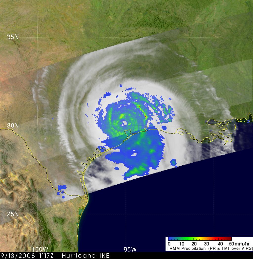
13 September 2008
HURRICANE IKE OVER TEXAS
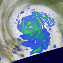
Hurricane IKE made landfall at Galveston, Texas on 13 September 2008 at about 2:10 CDT ( 0710 UTC) as
a destructive category two hurricane on the Saffir-Simpson scale with winds of 95 knots
( 110 mph). The image on the right used TRMM data captured about 4 hours later
at 6:17 CDT (1117 UTC). It showed that IKE hadn't lost much of it's intensity. It was still a well
organized hurricane with an eye that was clearly defined by TRMM's Precipitation Radar (PR) data.
Large areas of moderate to heavy rainfall are shown surrounding IKE in the TRMM rainfall analysis.
|
|
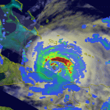
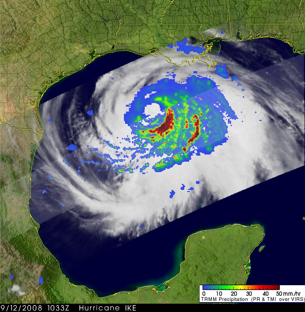
12 September 2008
HURRICANE IKE HEADED FOR TEXAS
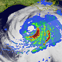
The TRMM satellite passed over enormous hurricane IKE that filled much of the Gulf Of Mexico on the morning of 12 September 2008 at 1033 UTC( 5:33 AM LOCAL TIME). The TRMM Precipitation Radar (PR) and TRMM Microwave Imager (TMI) instruments made it clear by peering through the cloud canopy that hurricane IKE had a large eye and a very large area of intense rainfall mostly concentrated in the southeastern part of
the storm. Bands of rainfall in this area were shown by the TRMM satellite to exceed 50 millimeters (~2 inches) per hour. The National Hurricane Center
forecast track indicated that hurricane IKE would be over
the Texas coast early in the morning of Saturday 13 September 2008.
|
|
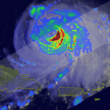
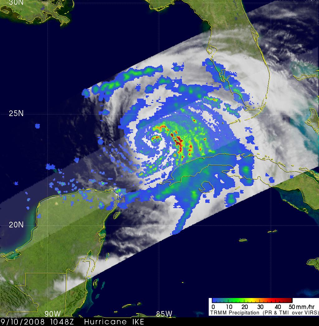
10 September 2008
HURRICANE IKE NOW IN THE GULF
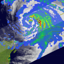
The TRMM satellite had good coverage as it passed over hurricane IKE in the Gulf Of Mexico on 10 September 2008 at 1048 UTC( 6:48 AM EDT). This image indicated that IKE was
already showing increased rainfall intensity. Rainfall intensity of close to 50mm hour (~2 inches) can be seen
in IKE's eye wall which shows an increase in the release of energy called the latent heat of condensation which can fuel a strengthening hurricane.
|
|
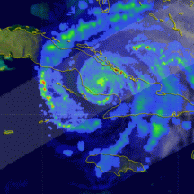
9 September 2008
HURRICANE IKE OVER WESTERN CUBA
Hurricane IKE was over western Cuba when the TRMM satellite received those data used in the image on the right at 1818 UTC (2:18 PM EDT) on 9 September 2008. IKE was a category one hurricane
on the Saffir-Simpson scale with wind speeds of about 65 knots (75 mph) at the time of this image. This meant that
the mountains of eastern Cuba had taken a toll on IKE which was a powerful category four hurricane with wind speeds of 105 knots (121 mph) before Cuban landfall. The National Hurricane Center
expects IKE to strengthen and become a major hurricane again as it moves west-northwestward into the warm waters of the Gulf Of Mexico.
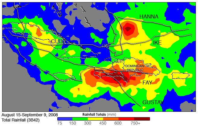
Click to see a rainfall accumulation analysis of this area.
|
|
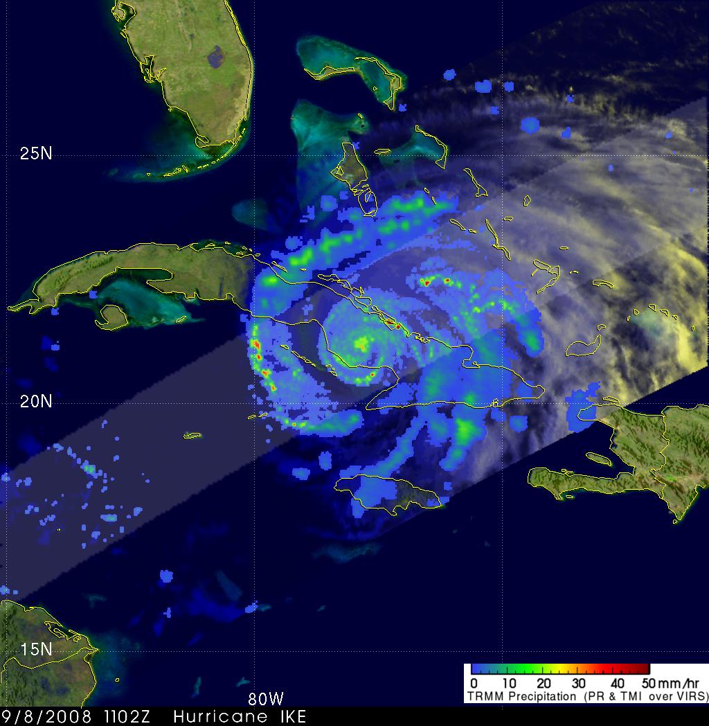
8 September 2008
HURRICANE IKE OVER CUBA
Hurricane IKE was battering Cuba with sustained winds of about 85 knots (98 mph) when the TRMM satellite
passed over on 8 September 2008 at 1102 UTC (7:02 AM EDT). Data were captured that were used to make
the TRMM satellite rainfall analysis on the right. IKE was predicted by the National Hurricane Center to move into the southeastern Gulf Of Mexico by Tuesday night as a minimal hurricane.
|
|
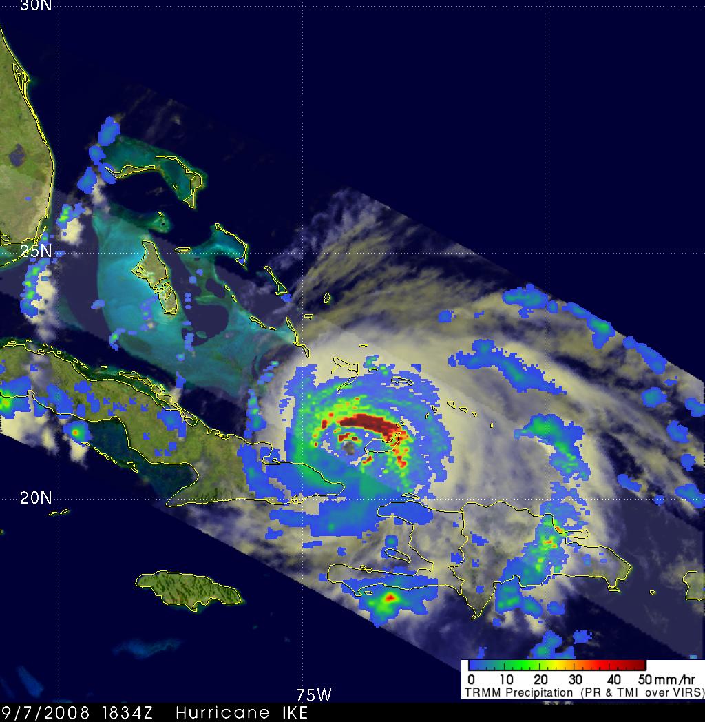
7 September 2008
CAT 4 IKE HITS GREAT INAGUA ISLAND
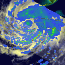
This image of hurricane IKE used TRMM data taken at 1834 UTC (2:34 PM EDT) 7 September 2008 after IKE
devastated the Bahamas' Great Inagua island. IKE was a powerful category four hurricane on the SAFFIR-SIMPSON
scale at this time with wind speeds of 115 knots (132 mph). IKE also caused deadly floods in HAITI
as it passed to the north of that country. The rainfall analysis shown on this image was made
with data from the TRMM Precipitation Radar (PR) and TRMM Microwave Imager (TMI) instruments . They are overlaid
on an image that used TRMM's Visible and infrared (VIRS) data.
|
|
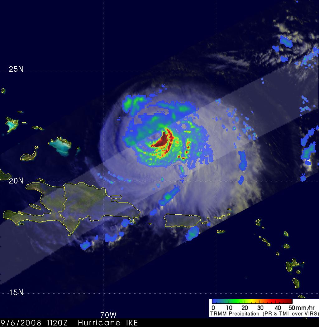
6 September 2008
HURRICANE IKE AGAIN A CAT 3
TRMM obtained the data used in this image of hurricane IKE at 11:20 UTC (7:20 AM EDT) 6 September 2008 as
IKE was moving toward the Bahamas with wind speeds estimated to be 100 knots (115 mph) making it
again a category three hurricane on the SAFFIR-SIMPSON scale.
A large area of intense thunderstorms with rainfall intensity greater than 50 millimeters per hour (~2 inches)
is shown just southeast of the eye.
|
|
Click to see earlier story by Steve Lang (10 September 2008)
SURGE IN ATLANTIC ACTIVITY COINCIDES WITH PEAK OF HURRICANE SEASON
Images and Captions by Hal Pierce (SSAI/NASA GSFC)
The Tropical Rainfall Measuring Mission (TRMM) is a joint mission between NASA and the Japan Aerospace Exploration Agency (JAXA) designed to monitor and study tropical rainfall.


