Local Forecast by
"City, St" or ZIP code |
|
Search by city or zip code. Press enter or select the go button to submit request |
|
|
|
| Quick
Glimpse at the Weather |
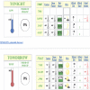
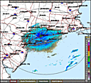
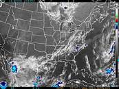
| An upper level trough will swing through the region this evening, and a surface high will remain in place through Wednesday. A cold front will pass through the region late Wednesday night into Thursday morning. Surface high pressure then builds back into the northeast to close out the work week, moving offshore by Saturday. Another cold front approaches on Sunday. See Full Discussion |
|
| Choose
from the options below for other ways to view your NWS
forecast |
| |
|
|
|
Local Information
Pages:
Winter Weather--Tropical
Weather--Severe Weather--Fire
Weather--Heat
Other News:
-
-
- Automated Climate Data, Local Forecasts, Marine Forecasts &
Tide Reports
are also available 24 hours a day from your local NWS Office at
631-924-0517.
|