|
|
 |
Hurricane Ike Strengthens in the Gulf of Mexico on September 10, 2008
|
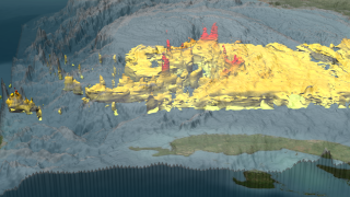
NASA's TRMM spacecraft observed this view of Hurricane Ike on September 10, 2008 as slammed into Cuba . At this time the storm was a category 1 hurricane with sustained winds of 75 knots (86.25 mph) and a pressure reading of 963 millibars. At this time, TRMM's data and aircraft reports confirm the small inner eye is eroding as the outer bands, shown here as red towers, are becoming better defined. This could limit rapid intensity development in the very near term, but the storm is projected to strengthen before it makes landfall. The cloud cover in this animation is taken by TRMM's Visible and Infrared Scanner(VIRS) and the GOES spacecraft. The rain structure is taken by TRMM's Tropical Microwave Imager (TMI) and TRMM's Precitation Radar(PR) instruments. TRMM looks underneath of the storm's clouds to reveal the underlying rain structure. The colored isosurface uner the clouds show the rain seen by the PR instrument. This surface is colored according to cloud height where yellow represents 10 km thunderclouds and red represents 12 km more intense thunderclouds.
|
|
|
|
NASA's TRMM satellite peers beneath the clouds to capture this view of Hurricane Ike. The 12 km towers in the outer band, shown in red, lead scientists to believe that the inner eye is eroding as the outer bands are becoming better defined. This could limit rapid intensity development in the very near term.
Duration: 28.0 seconds
Available formats:
1280x720 (60 fps)
Frames
1280x720 (30 fps)
Frames
1920x1080
TIFF
2 MB
3840x2160
TIFF
7 MB
320x180
PNG
297 KB
160x80
PNG
67 KB
80x40
PNG
17 KB
512x288 (30 fps)
MPEG-1
5 MB
1280x720 (29.97 fps)
MPEG-4
30 MB
How to play our movies
|
|
|
|
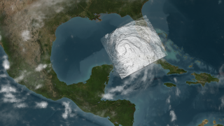
Hurricane Ike strengthens in the Gulf of Mexico on September 10, 2008.
Available formats:
3840 x 2160
TIFF
8 MB
320 x 180
PNG
288 KB
160 x 80
PNG
66 KB
80 x 40
PNG
17 KB
|
|
|
Back to Top
|
|
|
|

