|
|
 |
BlueMarble Next Generation Images from Terra/MODIS
|
The Blue Marble Next Generation (BMNG) data set provides a monthly global cloud-free true-color picture of the Earth's landcover at a 500-meter spatial resolution. This data set, shown on a globe, is derived from monthly data collected in 2004. The ocean color is derived from applying a depth shading to the bathymetry data. The Antarctica coverage snown is the Landsat Image Mosaic of Antarctica. Behind the Earth is a skymap from the Tycho and Hipparcos star catalogs. This skymap is plotted in plate carrée projection (Cylindrical-Equidistant) using celestial coordinates making them suitable for mapping onto spheres in many popular animation programs. The stars are plotted as gaussian point-spread functions (PSF) so the size and amplitude of the stars corresponds to their relative intensity. The stars are also elongated in Right Ascension (celestial longitude) based on declination (celestial latitude) so stars in the polar regions will still be round when projected on a sphere. Stars fainter than the threshold magnitude, usually selected as 5th magnitude, have their magnitude-intensity curve adjusted so they appear brighter than they really are. This makes the band of the Milky Way more visible. Stellar colors are assigned based on B and V magnitudes (B and V are stellar magnitudes measured through different filters). If Tycho B and V magnitudes are unavailable, Johnson B and V magnitudes are used instead. From these, an effective stellar temperature is derived using the algorithms described in Flower (ApJ 469, 355 1996). Corrections were noted from Siobahn Morgan (UNI). The effective temperature was then converted to CIE tristimulus X,Y,Z triples assuming a black-body emission distribution. The X,Y,Z values are then converted to red-green-blue color pixels. About 2.4 million stars are plotted, but many may be below the pixel intensity resolution. The three most conspicuously missing objects on these maps are the Andromeda galaxy (M31) and the two Magellanic Clouds.
|
|
|
|
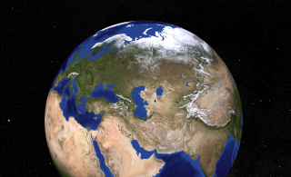
The Caspian Sea is the largest enclosed body of water on Earth by area. It has a surface area of 371,000 square kilometers (143,244 sq mi) and a volume of 78,200 cubic kilometers (18,761 cu mi). It has a salinity of approximately 1.2%, about a third the salinity of most seawater.
Available formats:
7506 x 4587
TIFF
37 MB
320 x 195
PNG
322 KB
|
|
|
|
View the Mediterranean Sea, Aegean Sea, Adriatic Sea, Baltic Sea, Dead Sea, Caspian Sea, Aral Sea, Red Sea, and the Persian Gulf.
Available formats:
7506 x 4587
TIFF
39 MB
320 x 195
PNG
323 KB
|
|
|
|
The outline of North America is exceedingly irregular; some extensive coastal reaches are relatively smooth, but by and large the coastline is broken and embayed, with many prominent offshore islands. The continent has three enormous coastal indentations: Hudson Bay in the northeast, the Gulf of Mexico in the southeast, and the Gulf of Alaska in the northwest.
Available formats:
7506 x 4587
TIFF
35 MB
320 x 195
PNG
316 KB
|
|

|
|
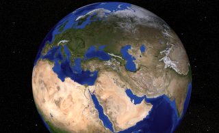
This image of the Mediterranian Sea shows that this inland sea is bordered on the north by Europe, the east by Asia, and in the south by Africa. This 969,100 sq. mile body of water is approximately 2,300 miles in length, and has a maximum depth of 16,896 ft. Major subdivisions include the Adriatic Sea, Aegean Sea, Balearic Sea, Tyrrhenian Sea, Ionian Sea and Ligurian Sea.
Available formats:
7506 x 4587
TIFF
38 MB
320 x 195
PNG
317 KB
|
|
|
|
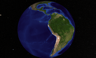
South America, the planet's 4th largest continent, includes (12) countries and (3) major territories. It contains the massive Amazon River and surrounding basin - the largest tropical rain forest in the world; the toothy-edged Andes Mountains, that stretch the entire length of the continent, and some of the most diverse and spectacular landforms on the planet.
Available formats:
7506 x 4587
TIFF
27 MB
320 x 195
PNG
306 KB
|
|
|
|
This image shows the 3 regions in North Africa: The Sahara, the Sahel, and the Sudan. The Sahel, a word derived from the Arabic ’sahil’ meaning shore, is a semi-arid belt of barren, sandy and rock-strewn land which stretches 3,860km across the breadth of the African continent and marks the physical and cultural divide between the continent’s more fertile south (the Sudan Region) and Saharan desert north.
Available formats:
5400 x 3300
TIFF
19 MB
320 x 195
PNG
319 KB
160 x 80
PNG
66 KB
80 x 40
PNG
17 KB
|
|
|
|
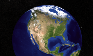
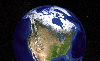
This image contains a view of the United States, Canada, and Greenland.
Available formats:
5400 x 3300
TIFF
20 MB
320 x 195
PNG
318 KB
|
|

|
|
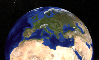
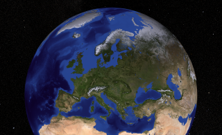
Europe, the planet's 6th largest continent includes 47 countries and assorted dependencies and territories. The European continent is separated from Asia by Russia's Ural Mountains, and the Caspian and Black Seas.
Available formats:
5400 x 3300
TIFF
20 MB
320 x 195
PNG
318 KB
|
|
|
|
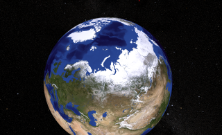
This image shows the Arctic. The North Pole is in the middle of the Arctic Ocean. The Arctic Ocean is surrounded by Alaska, Canada, Greenland, and Russia. The ocean is 4000 meters deep. Although it is an ocean, it is water you can walk on. There are 2-3 meter thick ice floes floating on the water at the North Pole. In summer the temperatures are near 0 centigrade and there is light. In winter the temperature is about -30 centigrade and it is dark.
Available formats:
5400 x 3300
TIFF
21 MB
320 x 195
PNG
321 KB
|
|

|
|
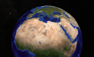
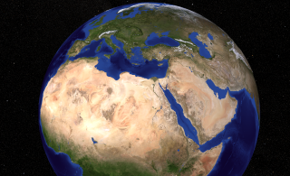
North Africa is the northernmost region of the African continent, separated by the Sahara from Sub-Saharan Africa.The Atlas Mountains, which extend across much of Morocco, northern Algeria and Tunisia, are part of the fold mountain system which also runs through much of Southern Europe.
Available formats:
7506 x 4587
TIFF
38 MB
320 x 195
PNG
321 KB
|
| Animation Number: | 3539 |
| Animators: | Lori Perkins (SVS) (Lead) |
| | Tom Bridgman (SVS) |
| Completed: | 2008-08-20 |
| Instrument: | Terra/MODIS |
| Data set: | Blue Marble Next Generation Seasonal Landcover |
| Data Collected: | Blue Marble Next Generation Seasonal Landcover: 2004-01 to 2004-12 |
Keywords:
DLESE
>> Cryology
SVS
>> HDTV
SVS
>> Sea Ice
GCMD
>> EARTH SCIENCE
>> Cryosphere
|
|
Please give credit for this item to
NASA/Goddard Space Flight Center Scientific Visualization Studio The Blue Marble Next Generation data is courtesy of Reto Stockli (NASA/GSFC). |
|
Back to Top
|
|
|
|

