Seasonal Landcover for Science-on-a-Sphere
|
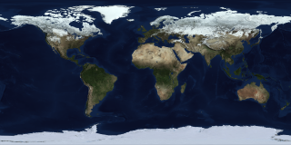
The Blue Marble Next Generation (BMNG) data set provides a monthly global cloud-free true-color picture of the Earth's land cover at a 500-meter spatial resolution. This series of images fades from month to month showing seasonal variations such as snowfall, spring greening and droughts in a seamless fashion. This data set, shown on a flat cartesian grid, is derived from monthly data collected in 2004. The ocean color is derived from applying a depth shading to the bathymetry data. The Antarctica coverage snown is the Landsat Image Mosaic of Antarctica.
|
|
|
|
Fade from month to month over the seasonal landcover data.
Duration: 12.0 seconds
Available formats:
800x400 (30 fps)
MPEG-4
1 MB
4000x2000 (6 fps)
Frames
320x160
PNG
244 KB
160x80
PNG
63 KB
80x40
PNG
16 KB
How to play our movies
|
|
This product is available through our Web Map Service.
Click here to learn more.
|
| Animation Number: | 3523 |
| Animator: | Cindy Starr (SVS) (Lead) |
| Completed: | 2008-06-30 |
| Instruments: | Aqua/MODIS
|
| | Terra/MODIS |
| Data sets: | Blue Marble Next Generation Seasonal Landcover
|
| | LandSat Image Mosaic of Antarctica |
| Data Collected: | BMNG: 2004-01-01 through 2004-12-31, LIMA: 12/25/1999 - 12/31/2001 |
Keywords:
DLESE
>> Physical geography
GCMD
>> EARTH SCIENCE
>> Land Surface
>> Land Use/Land Cover
>> Land Cover
SVS
>> Science on a Sphere
|
| DEPC Metadata is available here. |
|
Please give credit for this item to
NASA/Goddard Space Flight Center Scientific Visualization Studio
The Blue Marble Next Generation data is courtesy of Reto Stockli (NASA/GSFC). |
|
Back to Top
|

