Surface Temperature of the Greenland Ice Sheet During the Summer of 2005
|
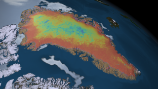
The surface temperature of the Greenland Ice Sheet is a sensitive indicator of surface melt extent, frequency, timing and duration. The daily clear-sky surface temperature of the Greenland Ice Sheet was measured using MODIS–derived land surface temperature (LST) data-product maps. For this animation, an 8-day moving average of clear-sky surface temperature was generated from May 1 through September 1, 2005. Coldest temperatures are shown here in violet and blue, while warmer temperatures nearing the melting point of zero degrees centigrade are shown in orange and red. The summer season is repeated two times in this animation.
|
|
|
|
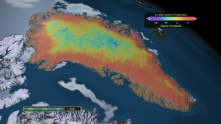
This animation shows daily surface temperature of the Greenland ice sheet from May 1 through September 1, 2005. An overlay contains a date bar, a color bar and text labels.
Duration: 1.2 minutes
Available formats:
1280x720 (30 fps)
MPEG-4
56 MB
640x360 (30 fps)
MPEG-4
13 MB
1280x720 (30 fps)
MPEG-2
58 MB
512x288 (30 fps)
MPEG-1
14 MB
1280x720 (30 fps)
Frames (Composite)
1280x720 (30 fps)
Frames (Overlay)
320x180
PNG
252 KB
160x80
PNG
62 KB
80x40
PNG
16 KB
How to play our movies
|
|

|
|
This animation shows daily surface temperature of the Greenland ice sheet from May 1 through September 1, 2005.
Duration: 1.2 minutes
Available formats:
1280x720 (30 fps)
MPEG-4
56 MB
640x360 (30 fps)
MPEG-4
13 MB
1280x720 (30 fps)
MPEG-2
56 MB
512x288 (30 fps)
MPEG-1
13 MB
1280x720 (30 fps)
Frames (Background)
320x180
PNG
253 KB
How to play our movies
|
|
|
|
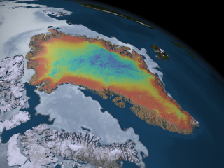
An image of the average ice sheet surface temperature over Greenland from June 16 through June 24, 2005.
Available formats:
2560 x 1920
TIFF
5 MB
1280 x 720
TIFF
1 MB
320 x 240
PNG
344 KB
|
|
|
|
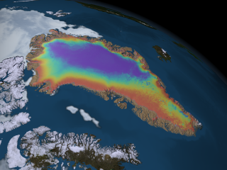
An image of the average ice sheet surface temperature over Greenland from August 5 through August 13, 2005.
Available formats:
2560 x 1920
TIFF
5 MB
1280 x 720
TIFF
1 MB
320 x 240
PNG
330 KB
|
|
|
|
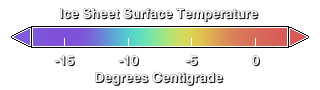
Colorbar for the MODIS Land Surface Temperature.
Available formats:
320 x 90
PNG
15 KB
|
|
|
Back to Top
|

