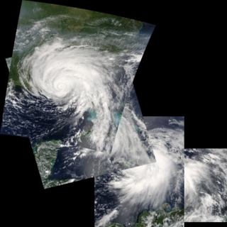
Progression of Hurricane Dennis, 2005 (WMS)
|
The formation of Hurricane Dennis on July 5 made that the earliest date on record that four named storms formed in the Atlantic basin. Dennis proved to be a powerful and destructive storm in the Caribbean Sea and the Gulf of Mexico. It crossed over Cuba on July 8 and 9, leaving at least 10 dead, and caused additional deaths in Haiti. After re-emerging over open water, Dennis re-strengthened into a dangerous Category 4 hurricane with top wind speeds of 233 kilometers per hour (145 mph). The storm passed within 90 kilometers (55 miles) of Pensacola, Florida, and hit land about 80 kilometers (50 miles) east of where Hurricane Ivan struck in September, 2004. A large storm surge of more than 10 feet was created in certain areas, and many homes and businesses in low-lying areas were flooded.
|
|

|
|
This image shows a composite of the individual images available.
Available formats:
Sequence
1024x1024
PNG
1 MB
1024x1024
TIFF
1 MB
320x320
JPEG
60 KB
80x40
PNG
7 KB
160x80
PNG
26 KB
How to play our movies
|
|
This product is available through our Web Map Service.
Click here to learn more.
|
|
|
|
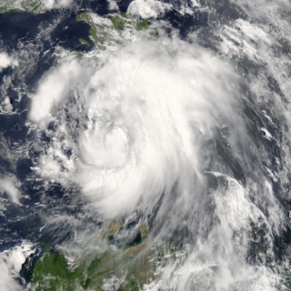
July 6, 2005 15:05 (UTC)
Tropical Storm Dennis spanned from the northern tip of Venezuela to the southern half of the island of Hispaniola in this image. Dennis was here growing to winds of 110 kilometers per hour (70 mph).
Available formats:
1024 x 1024
TIFF
2 MB
320 x 320
JPEG
83 KB
|
|
|
|
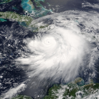
July 7, 2005 15:50 (UTC)
Hurricane Dennis threaded its way between Jamaica and Haiti on a direct course for Cuba on July 7, 2005. In this image, Dennis was just below a Category 3 hurricane, with winds of 175 kilometers per hour (110 miles per hour) and stronger gusts.
Available formats:
1024 x 1024
TIFF
2 MB
320 x 320
JPEG
84 KB
|
|
|
|
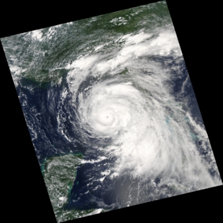
July 9, 2005 18:45 (UTC)
After crossing Cuba, Dennis regained strength into a dangerous Category 3 hurricane with winds approaching 185 kilometers per hour (115 mph) when this image was taken.
Available formats:
1024 x 1024
TIFF
1 MB
320 x 320
JPEG
65 KB
|
|
|
|
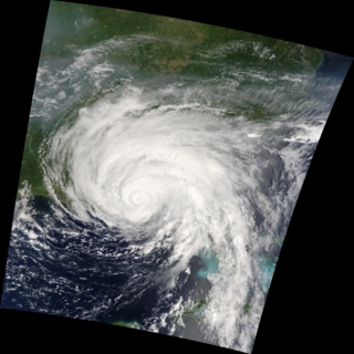
July 10, 2005 16:15 (UTC)
With winds of 217 kilometers per hour (135 mph), Hurricane Dennis was a powerful Category 4 storm just hours away from making landfall. At the time this image was taken, the eye of the storm was about 90 kilometers (55 miles) south, southeast of Pensacola, Florida, and the storm was moving northwest at about 29 kilometers per hour (18 mph).
Available formats:
1024 x 1024
TIFF
1 MB
320 x 320
JPEG
65 KB
|
|
|
Back to Top
|


