Skip all navigation and jump to content Jump to site navigation Jump to section navigation.
NASA Logo - Goddard Space Flight Center + Visit NASA.gov
HOME PROJECTS RESOURCES SEARCH MAP

+ Advanced Search
Home
Home
View Most Recently Released Imagery
View Gallery of Imagery: A topical collection of SVS Imagery
Search Imagery by the keywords assigned to it
Search Imagery by the instruments that supplied data for a visualization product
Search Imagery by the series of visualizations that have been produced
Search Imagery by the scientist providing the data used in a visualization product
Search Imagery by the animator that created the product
Search Imagery by the identification number assigned to the visualization product
See other search options
Learn about the SVS Image Server
  + About the Server
  + Animation List
  + How to Use the Server


  + RSS Feeds
blank image
Previous Animation
Next Animation
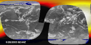
Incoming Solar Flux Compared to Clouds (WMS)

The Earth's climate is determined by energy transfer from the sun to the Earth's land, oceans, and atmosphere. As the Earth rotates, the sun lights up only part of the Earth at a time, and some of that incoming solar energy is reflected and some is absorbed, depending on type of area it lights. The amount of reflection and absorption is critical to the climate. An instrument named CERES orbits the Earth every 99 minutes and measures the reflected solar energy. This animation shows the incoming solar radiation within view of CERES during 29 orbits on June 20 and 21 of 2003. Because this is incoming solar flux, its magnitude only depends on the position of the sun, and, because the orbit is synchronized with the sun, the orbit crosses the equator in the daylight at about 1:30 PM local time on every orbit. This data is not actually measured from CERES, but is calculated to compare with the outgoing radiation that CERES does measure. Note that the infrared cloud image shown under the solar data shows high infrared as dark (land) and low infrared as light (clouds).

This animation shows incoming solar flux corresponding to 29 orbits (2 days) of CERES measurements, from June 20-21, 2003. This data is calculated using data from SORCE for the flux magnitude at the Earths orbit, coupled with solar incidence angles based on CERES measurement locations and times.  The measurements are superimposed over a global infrared cloud cover composite from the same period.    This animation shows incoming solar flux corresponding to 29 orbits (2 days) of CERES measurements, from June 20-21, 2003. This data is calculated using data from SORCE for the flux magnitude at the Earths orbit, coupled with solar incidence angles based on CERES measurement locations and times. The measurements are superimposed over a global infrared cloud cover composite from the same period.
Duration: 29.0 seconds
Available formats:
  320x160     PNG           65 KB
  160x80       PNG           19 KB
  80x40         PNG           6 KB
  640x320 (29.97 fps) MPEG-1   5 MB
  1024x512   Frames
How to play our movies

This product is available through our Web Map Service.   Click here to learn more.


This is the legend for the incoming solar flux animation, indicating the magnitudes of incident energy flux.
   This is the legend for the incoming solar flux animation, indicating the magnitudes of incident energy flux.

Available formats:
  320 x 90           PNG   1 KB

Animation Number:3178
Animators:Horace Mitchell (SVS) (Lead)
 Eric Sokolowsky (SVS)
Completed:2005-06-21
Scientist:Bruce A. Wielicki (NASA/LaRC)
Instruments:GOES-9/Imager
 SORCE/TIM
 GOES-12/Imager
 GOES-10/Imager
 Meteosat-7/VISSR
Data sets:Cloud Cover
 Incoming Solar Radiation
Data Collected:2003/06/20-2003/06/22
Series:WMS
Keywords:
GCMD >> EARTH SCIENCE >> Atmosphere >> Atmospheric Radiation >> Incoming Solar Radiation
GCMD >> EARTH SCIENCE >> Atmosphere >> Atmospheric Radiation >> Solar Irradiance
GCMD >> EARTH SCIENCE >> Atmosphere >> Clouds >> Cloud Reflectance
GCMD >> EARTH SCIENCE >> Sun-earth Interactions >> Solar Activity >> Solar Irradiance
More Information on this topic available at:
http://asd-www.larc.nasa.gov/ceres/ASDceres.html
View Animation in Google Earth Google Earth KML file is available here.
DEPC Metadata is available here.
 
 
Please give credit for this item to
NASA/Goddard Space Flight Center
Scientific Visualization Studio


Back to Top

USA.gov logo - the U.S. Government's official Web portal. + Privacy Policy and Important Notices
+ Reproduction Guidelines
NASA NASA Official:
SVS Contact:
Curator: