Skip all navigation and jump to content Jump to site navigation Jump to section navigation.
NASA Logo - Goddard Space Flight Center + Visit NASA.gov
HOME PROJECTS RESOURCES SEARCH MAP

+ Advanced Search
Home
Home
View Most Recently Released Imagery
View Gallery of Imagery: A topical collection of SVS Imagery
Search Imagery by the keywords assigned to it
Search Imagery by the instruments that supplied data for a visualization product
Search Imagery by the series of visualizations that have been produced
Search Imagery by the scientist providing the data used in a visualization product
Search Imagery by the animator that created the product
Search Imagery by the identification number assigned to the visualization product
See other search options
Learn about the SVS Image Server
  + About the Server
  + Animation List
  + How to Use the Server


  + RSS Feeds
blank image
Previous Animation
Next Animation
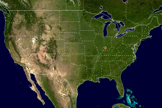
United States Median Center of Population, 1880-2000 (WMS)

The median center of population is calculated from the intersection of two median lines. The first median line is the geographic line running north and south that divides the population into two equal halves, east and west. The second median line is the geographic line running east and west that divides the population into two equal halves, north and south. For the 2000 United States Census, the median center of population was located in Van Buren township, Daviess County, Indiana. For a complete list of the median center of population for each census since 1880, and for a more detailed description of how these values are calculated, see (http://www.census.gov/geo/www/cenpop/calculate2k.pdf).

This animation shows the median center of population for the United States from each census from 1880-2000.    This animation shows the median center of population for the United States from each census from 1880-2000.
Duration: 6.0 seconds
Available formats:
  720x480 (29.97 fps) MPEG-2   5 MB
  320x213     PNG           279 KB
  80x40         PNG           11 KB
  320x240 (30 fps) MPEG-1   1 MB
  640x480 (30 fps) MPEG-1   1 MB
How to play our movies

This product is available through our Web Map Service.   Click here to learn more.
Animation Number:3164
Animator:Eric Sokolowsky (SVS) (Lead)
Completed:2005-05-23
Instrument:Airborne Topographic Mapper
Series:WMS
Keywords:
DLESE >> Human geography
GCMD >> EARTH SCIENCE >> Human Dimensions >> Population >> Population Distribution
View Animation in Google Earth Google Earth KML file is available here.
DEPC Metadata is available here.
 
 
Please give credit for this item to
NASA/Goddard Space Flight Center
Scientific Visualization Studio


Back to Top

USA.gov logo - the U.S. Government's official Web portal. + Privacy Policy and Important Notices
+ Reproduction Guidelines
NASA NASA Official:
SVS Contact:
Curator: