Skip all navigation and jump to content Jump to site navigation Jump to section navigation.
NASA Logo - Goddard Space Flight Center + Visit NASA.gov
HOME PROJECTS RESOURCES SEARCH MAP

+ Advanced Search
Home
Home
View Most Recently Released Imagery
View Gallery of Imagery: A topical collection of SVS Imagery
Search Imagery by the keywords assigned to it
Search Imagery by the instruments that supplied data for a visualization product
Search Imagery by the series of visualizations that have been produced
Search Imagery by the scientist providing the data used in a visualization product
Search Imagery by the animator that created the product
Search Imagery by the identification number assigned to the visualization product
See other search options
Learn about the SVS Image Server
  + About the Server
  + Animation List
  + How to Use the Server


  + RSS Feeds
blank image
Previous Animation
Next Animation
Mount Kilimanjaro's Vanishing Snow Cap (WMS)

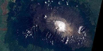
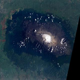
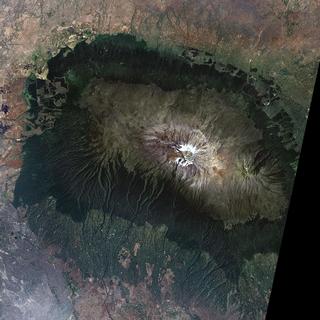
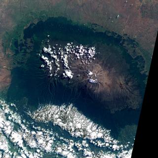
During the last few decades, the permanent snow and ice on the summit of Mount Kilimanjaro has almost completely disappeared, at the rate of about a foot and a half of glacial ice lost per year. This loss is primarily due to increasing average annual temperatures in the region, and scientists are speculating that the glaciers could be completely gone from Kilimanjaro by the year 2015. This ice cap formed more than 11,000 years ago, and 80% of the ice fields have been lost in only the last century. The shrinkage is illustrated here in Landsat images from 1993, 2000, and 2002, with the 1993 image showing a significant ice cap and the more recent images showing only small glaciers and snow regions remaining.

An animation of the shrinking snow cap on Mount Kilimanjaro from Landsat imagery    An animation of the shrinking snow cap on Mount Kilimanjaro from Landsat imagery
Duration: 6.0 seconds
Available formats:
  320x320 (29.97 fps) MPEG-1   1 MB
  160x80       PNG           22 KB
  360x180     JPEG         11 KB
  80x40         PNG           6 KB
How to play our movies

This product is available through our Web Map Service.   Click here to learn more.

Landsat imagery of Mount Kilimanjaro acquired on February 17, 1993.    Landsat imagery of Mount Kilimanjaro acquired on February 17, 1993.

Available formats:
  2048 x 2048     TIFF 11 MB
  320 x 320         JPEG 15 KB


Landsat imagery of Mount Kilimanjaro acquired on February 21, 2000.    Landsat imagery of Mount Kilimanjaro acquired on February 21, 2000.

Available formats:
  2048 x 2048     TIFF 12 MB
  320 x 320         JPEG 18 KB


Landsat imagery of Mount Kilimanjaro acquired on June 2, 2002.    Landsat imagery of Mount Kilimanjaro acquired on June 2, 2002.

Available formats:
  2048 x 2048     TIFF 11 MB
  320 x 320         JPEG 22 KB

Animation Number:3125
Animators:James W. Williams (SVS) (Lead)
 Horace Mitchell (SVS)
 Marte Newcombe (SVS)
Completed:2005-03-07
Scientist:Darrel Williams (NASA/GSFC)
Instruments:Landsat-5/TM
 Landsat-7/ETM+
Data Collected:1993/02/17, 2000/02/21, 2002/06/02
Series:WMS
Keywords:
DLESE >> Cryology
GCMD >> EARTH SCIENCE >> Cryosphere >> Glaciers/Ice Sheets >> Glaciers
GCMD >> EARTH SCIENCE >> Cryosphere >> Snow/Ice >> Snow Cover
More Information on this topic available at:
stories/kilimanjaro_20021216/index.html
View Animation in Google Earth Google Earth KML file is available here.
DEPC Metadata is available here.
 
 
Please give credit for this item to
NASA/Goddard Space Flight Center
Scientific Visualization Studio


Back to Top

USA.gov logo - the U.S. Government's official Web portal. + Privacy Policy and Important Notices
+ Reproduction Guidelines
NASA NASA Official:
SVS Contact:
Curator: