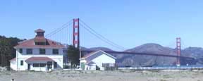
Gulf of Farallones National Marine Sanctuary Gulf of the Farallones National Marine Sanctuary National Marine Sanctuaries NOAA
home  | what's new  | calendar  | weather & tides  | about us  | site index  |

explore the GFNMS

managing the GFNMS

GFNMS research

GFNMS education

GFNMS ecosystem protection

welcome to the Gulf of the Farallones


Map of sanctuaries off San Francisco


Visitor Center near the Golden Gate Bridge

Sanctuary Visitor Center at Crissy Field in San Francisco.
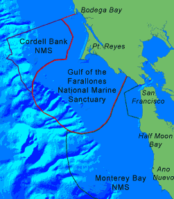
What's New at the Sanctuary?

NEWApplications are now being accepted for vacant Advisory Council seats

NEW SIMoN - Sanctuary Integrated Monitoring Network

NEW Bolinas Lagoon Ecosystem Restoration Project

NEW TYO Podcast Spotlights Sanctuary's Seals!

NEW Protecting Tomales Bay By Managing Vessel Usage

NEW 2007 State of the Sanctuaries Report

NEW Facilities Master Plan

Advisory Council

Joint Management Plan

Maps

Workshops

The Gulf of the Farallones National Marine Sanctuary protects an area of 948 square nautical miles (1,255 square miles) off the northern and central California coast. Located just a few miles from San Francisco, the waters within the Gulf of the Farallones National Marine Sanctuary are part of a nationally significant marine ecosystem. Encompassing a diversity of highly productive marine habitats, the Sanctuary supports an abundance of species.

contact | directions | media | privacy policy

This page was last updated on January 1, 2007
2007 Gulf of the Farallones National Marine Sanctuary
website: farallones.noaa.gov | e-mail: farallones@noaa.gov
National Marine Sanctuaries | National Ocean Service | National Oceanic & Atmospheric Administration | USA.gov