Hurricane Ike Attacks the Gulf Coast on September 12, 2008
|
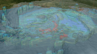
NASA's TRMM spacecraft observed this view of Hurricane Ike on September 12, 2008 at 1035Z or 6:35 AM EST. At this time the storm was an extremely dangerous category 2 hurricane with sustained winds of 90 knots (103 mph) and a pressure reading of 953 millibars. Hurricane-force winds were extending outward 120 miles from the center, while tropical storm-force winds extend up to 275 miles. Size matters when it comes to hurricanes. Larger storms produce a wider swath of wind damage and stir up the water that create a surge on a longer coastline. With Hurricane Ike, the wind field is exceptionally large and so is the destructive potential for storm surge. Surge flooding up to 25 feet is expected. The cloud cover in this animation is taken by TRMM's Visible and Infrared Scanner(VIRS) and the GOES spacecraft. The rain structure is taken by TRMM's Tropical Microwave Imager (TMI) and TRMM's Precitation Radar(PR) instruments. TRMM looks underneath of the storm's clouds to reveal the underlying rain structure. Blue represents areas with at least 0.25 inches of rain per hour. Green shows at least 0.5 inches of rain per hour. Yellow is at least 1.0 inches of rain and red is at least 2.0 inches of rain per hour.
|
|
|
|
Hurricane Ike threatens the entire Gulf Coast on September 12, 2008. The blue region represents areas where the storm is dumping at least 0.25 inches of rain per hour and the green region is raining 0.5 inches of inches per hour. Yellow is 1 inch of rain per hour and red is 2 inches of rain per hour.
Duration: 28.0 seconds
Available formats:
3840x2160
TIFF
7 MB
320x180
PNG
294 KB
160x80
PNG
66 KB
80x40
PNG
17 KB
640x320 (60 fps)
Frames
1280x720 (29.97 fps)
MPEG
30 MB
512x288 (30 fps)
MPEG
4 MB
640x320 (30 fps)
Frames
How to play our movies
|
|

|
|
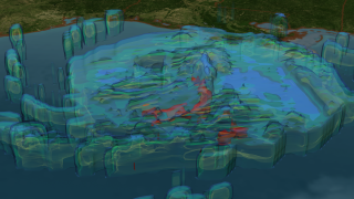
This image is the same as the above image with the cloud cover completely removed. The intense and far-reaching rain fuels this storm.
Available formats:
3840 x 2160
TIFF
7 MB
320 x 180
PNG
279 KB
|
|
|
|
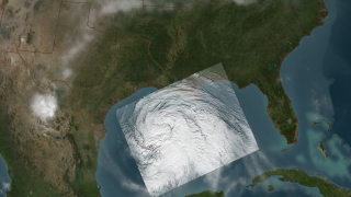
Hurricane Ike is an is exceptionally large storm. Hurricane-force winds extend outward 120 miles from the center, while tropical storm-force winds extend up to 275 miles
Available formats:
3840 x 2160
TIFF
10 MB
320 x 180
PNG
293 KB
|
|
|
|
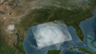
Surge flooding up to 25 feet is expected at landfall with significant surge flooding expected up to 200 miles away from the central landfall impact.
Available formats:
3840 x 2160
TIFF
10 MB
320 x 180
PNG
293 KB
|
|
|
Back to Top
|

