Local forecast by
"City, St" or zip code |
|
Search by city or zip code. Press enter or select the go button to submit request
|
| Rivers & Hydrology
|
 |
|
| Precip & Weather |
|
|
| Climate & History |
|
|
| Additional Info |
|
|
| About The LMRFC |
|
|
|
| Home
: |
|
| About
the LMRFC |
|
| Introduction |
|
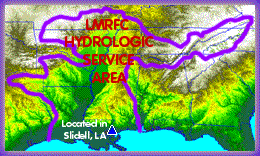 The
lower Mississippi River Forecast Center is in Slidell, LA (about 30
miles northeast of New Orleans), co-located with the New
Orleans Weather Forecast Office. Our office is open seven days
a week, 365 days a year, from 6am to 10pm, and is prepared to go 24
hours a day when necessary. We provide daily river forecasts on the
lower Mississippi River and its tributaries. This comprises over 200
sites in a 210, 000 square mile area throughout the southeast US. The
lower Mississippi River Forecast Center is in Slidell, LA (about 30
miles northeast of New Orleans), co-located with the New
Orleans Weather Forecast Office. Our office is open seven days
a week, 365 days a year, from 6am to 10pm, and is prepared to go 24
hours a day when necessary. We provide daily river forecasts on the
lower Mississippi River and its tributaries. This comprises over 200
sites in a 210, 000 square mile area throughout the southeast US. |
| History |
|
| The
Lower Mississippi River Forecast Center was founded in 1971 in
concert with the efforts to fund the Alaska
River Forecast Center, and officially commenced operations in
January of 1972. No single flood event can be identified as motivating
the formation of this RFC. Instead, its startup resulted from the
need to complete the coverage of the Nation by RFCs and to provide
coordinated forecasts for the economically critical lower Mississippi
basin. Since it commenced operation, the LMRFC responsibility area
of over 209,000 square miles has essentially remained unchanged. After
it was formed, the LMRFC was the first to demonstrate the routine
use of the nationally-supported operational forecast system which
would eventually become the NWS River Forecast System (NWSRFS). |
|