.
|
|
|
|
.
|
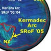
Expeditions to the Kermadec Arc, Mariana Arc and Explorer Ridge |
| Ring of Fire Expeditions: | |||||||||||||||||||||||
Submarine Ring of Fire 2006 Mariana Arc |
|||||||||||||||||||||||
| Media Links: Nature (5/24/06): Long-term eruptive activity at a submarine arc volcano NPR All Things Considered (5/24/06): Video Captures Underwater 'Brimstone and Fire' NOAA Press Release: Explorers Discover Undersea Volcano's Long-term Eruption |
|||||||||||||||||||||||
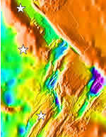
New
Zealand American Submarine Ring of Fire April
3 - May 10, 2005 |
|||||||||||||||||||||||
|
Return
to the Mariana Arc- First dives discover the hottest spots on any submarine volcano, a 60', smoking crater on NW Rota volcano!
Visit the 2004 Multimedia Gallery for all the videos, virtual reality and fly-throughs! The 2004 expedition used a remotely operated vehicle (ROV) to explore some of the 50 submarine volcanoes mapped on the 2003 expedition. Of utmost interest were the 10 volcanoes determined to be hydrothermally active. Media
Link- |
|||||||||||||||||||||||
Initial
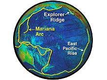
Survey of the Mariana Submarine Volcanoes- An interdisciplinary team of scientists explored the submarine volcanoes of the Mariana Arc lying north of Guam in the western Pacific from February 9 to March 5, 2003. It is here that most of the ocean crust, born along the mid-ocean ridges millions of years ago in the eastern Pacific (see Explorer Ridge expeditions), is “recycled” back into the earth’s mantle as the ocean floor descends into the Mariana trench. A portion of the ocean crust remelts and rises to the surface behind the trench along a line of more than 40 submarine volcanoes and volcanic islands extending north of Guam for more than 1000 kilometers. This was the first dedicated exploration of the submarine hydrothermal systems of the Mariana Arc. |
|||||||||||||||||||||||
Explorer
Ridge Expeditions- In June to August 2002, a team made up of U. S. and Canadian geologists, chemists, and biologists conducted two expeditions to the Explorer Ridge, a section of the world-girdling Mid-Ocean Ridge, to investigate the birth of new ocean crust off the coast of western North America, part of the Pacific "Ring of Fire". New earth crust is continuously generated along the Mid-Ocean Ridge system, a 60,000 km long volcanic system encircling the globe. This "crust" is eventually recycled back into the earth's mantle at the deep ocean trenches, such as the Marianas. In this sense, the ocean floor can be likened to a giant conveyor belt, with new ocean floor continuously created at mid-ocean ridges and ultimately recycled at island arcs and deep-ocean trenches. |
|||||||||||||||||||||||


 February
9 – March 5, 2003 (
February
9 – March 5, 2003 (