Global Analysis / Global Hazards / United States / U.S.
Drought / Extremes
Use these links to access detailed analyses of Global and U.S. data.

 Drought & Heat | Flooding | Storms | Tropical Cyclones | Extratropical Cyclones | Severe Winter Weather


Across the United States, extreme drought conditions were observed in areas of Wyoming and Nebraska, as well as northern Minnesota and parts of Texas. Exceptional drought was limited to areas of south Texas. |

U.S. Drought Monitor
|


Africa Rainfall Anomalies
|
Flooding in Mozambique was described as the worst in 6 years. An estimated 30 people were killed and 120,000 evacuated from the central Zambezi basin, according to the government's disaster-response agency. Additional flooding and loss of life was attributed to landfalling Tropical Cyclone Favio by late-month (OCHA-IRIN/IFRC).
|
In Indonesia, massive flooding on Java in early February resulted in 85 fatalities, with the majority of the deaths occuring in Jakarta. At the peak of the flooding, officials reported that about half of the city of Jakarta was covered by up to 3.7 meters (12 feet) of water. The flooding in the capital caused an estimated $1 billion (USD) in damage (AFP/Associated Press). |

Indonesia Flooding
|


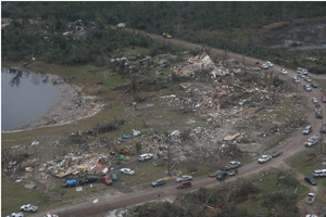
Severe thunderstorms produced tornadoes in central Florida during the early morning of February 2, producing the deadliest outbreak in nine years. Twenty-one fatalities were reported as tornadoes struck portions of Sumter county, ultimately affecting Lake and Volusia counties. This was Florida's deadliest tornado outbreak since the "Groundhog Day Storm" of 1998 killed 42 people in the Sunshine State (AFP). |

Lake County Florida Storm Damage
|
A tornado struck the New Orleans area on February 13, affecting some of the same neighborhoods impacted by Hurricane Katrina in 2005. There was one fatality and 29 injuries. About 21,000 electricity customers in the greater New Orleans area lost power during the storm (Associated Press).
|
In Swaziland, severe thunderstorms produced strong winds and hail during February 4-5, causing damage to 500 houses and producing widespread power outages. The Shiselweni and Lubombo regions were affected (IFRC).
|
In Australia, severe thunderstorms affected the capital city of Canberra on the 28th. The storm deposited significant accumulations of hail and produced serious flooding. The damage forced the closure of the Australian National University for nearly a week. |

Hail Storm In Canberra, Australia
|


Tropical Cyclone Nelson
|
Tropical Cyclone Nelson developed on the 5th in the Gulf of Carpentaria and moved eastward across Queensland's Cape York Peninsula during the 7th-8th with maximum sustained winds near 120 km/ht (65 knots or 75 mph). The cyclone dissipated thereafter, but not before depositing heavy rainfall in northeastern Queensland.
|
Tropical Cyclone Favio developed in the southern Indian Ocean on the 14th and tracked to the south of the southern tip of Madagascar on the 19th. Heavy rains lashed southern Madagascar, displacing 25,000 people (IFRC). The cyclone made landfall in Mozambique's Inhambane province near Vilanculos on the 22nd with maximum sustained winds near 205 km/hr (110 knots or 125 mph). There were at least four deaths and 70 injuries in Mozambique from Favio. The Zambezi River basin remained highly vulnerable to additional heavy rainfall after recent significant flooding events. |

Tropical Cyclone Favio
|

Tropical Cyclone Gamede
|
Tropical Cyclone Gamede developed in the southern Indian Ocean on the 21st and passed very slowly between Madagascar and Reunion Island during the last week of the month. While Gamede did not make a direct landfall on either island, exceptionally heavy rain fell on Reunion. Preliminary rainfall totals during February 21-28 were 5400 mm (212.6 inches). If confirmed, three to nine day rainfall amounts would set new world records (MeteoFrance).
|


No reports of significant extratropical cyclones were received during February 2007.
|


A major winter storm affected portions of the eastern United States and southeastern Canada during the 13th-14th, depositing significant accumulations of snow and ice from Illinois eastward into the Mid-Atlantic and Northeast. Snow accumulations in areas of upstate New York totaled in excess of 100 cm (39 inches). The winter storm was blamed for 13 deaths, and around 300,000 people lost power during the storm (AFP/CNN). In Canada, Montreal received almost as much snow in one day (53 cm or 21 inches) as was received winter-to-date. Until the snowstorm, Montreal had only recorded 70 cm (27.5 inches) of snowfall, or nearly half the normal value (AFP/Environment Canada). |

Northeast U.S. Snow Depth
|
Intense lake-effect snowfall in the lee of Lake Ontario deposited phenomenal snowfall accumulations in areas downwind of the lake. A ten-day storm total of 358 cm (141 inches) was reported in Redfield in New York's Oswego county by the 12th.
|
More severe winter weather occurred during the 24th-26th as snow and ice affected areas from the Plains eastward into the Mid-Atlantic. A total of 58 counties across the eastern two-thirds of Iowa were placed in a state of emergency by Iowa governor Chet Culver, with more than 100,000 Iowa residents without power. Some of the heaviest snow fell in southeastern Minnesota, where as much as 76 cm (30 inches) accumulated (Reuters).
|

For all climate questions other than questions concerning this report,
please contact the National Climatic Data Center's Climate Services
Division:
- Climate Services Division
NOAA/National Climatic Data Center
151 Patton Avenue, Room 120
Asheville, NC 28801-5001
fax: 828-271-4876
phone: 828-271-4800
email: ncdc.orders@noaa.gov
|

For further information on the historical climate perspective presented in this report, contact:
- Scott Stephens
NOAA/National Climatic Data Center
151 Patton Avenue
Asheville, NC 28801-5001
fax: 828-271-4328
email: Scott.Stephens@noaa.gov
|
|


