Global Analysis / Global Hazards / United States / U.S.
Drought / Extremes
Use these links to access detailed analyses of Global and U.S. data.


Typhoon Xangsane
|
Global Hazards And Significant Events
September 2006
Typhoon Xangsane pounded the Philippines late in the month before taking aim on Vietnam. Additional information can be found below.
|
 Drought & Heat | Flooding | Storms | Tropical Cyclones | Extratropical Cyclones | Severe Winter Weather

Across the United States, significant drought affected areas of the South, Southwest, southern and High Plains, northern Minnesota and the central Rocky Mountains. Exceptional drought was noted across portions of Texas and Oklahoma along the Red River. |

U.S. Drought Monitor
|


In Ethiopia, extensive flooding in August 2006 continued in September. Flooding was blamed for at least nine fatalities in Dire Dawa on the 13th (OHCA). Heavy rainfall that began last month continued in September in parts of Niger and Burkina Faso, rendering 22,000 people homeless. Nigeria, Mali and Mauritania also experienced flooding rains (AFP). |

Africa Rainfall Anomalies
|
Across eastern India, heavy rainfall during the 21st-25th produced flooding that caused 19 deaths in the state of Bihar (AFP). Monthly rainfall anomalies were in excess of +200 mm (7.9 inches) in southwestern India. |

India Rainfall Anomalies
|


Ernesto Rainfall
|
Tropical Storm Ernesto developed during the month of August but made landfall along the North Carolina coast near Long Beach just before midnight on September 1st with maximum sustained winds near 115 km/hr (60 knots or 70 mph). The primary impact from Ernesto was heavy rainfall along its course. Parts of eastern North Carolina and Virginia received 200-300 mm (8-12 inches of rainfall). Estimated crop losses were $59 million (USD) in North Carolina, while total lossed were near $90 million (USD) in Virginia (Associated Press).
|
Hurricane John developed in the eastern Pacific Ocean during August, but made landfall along Mexico's Baja Peninsula on the 1st near San Jose del Cabo with maximum sustained winds near 175 km/hr (95 knots or 110 mph). John was blamed for four deaths in Mexico (AFP). The storm also produced minor flooding farther north in parts of the U.S. Southwest, including parts of southern California, southern Arizona and New Mexico, as well as west Texas (Associated Press). |

John Rainfall
|

Typhoon Shanshan
|
Typhoon Shanshan developed in the Philippine Sea on the 10th, reaching typhoon strength the next day. Shanshan moved across Japan's southern island of Kyushu on the 17th with maximum sustained winds near 175 km/hr (95 knots or 110 mph). There were at least eight fatalities and around 100 injured in Japan (AFP).
|
Hurricane Lane formed on the 13th off the west coast of Mexico and reached hurricane status by the 15th. Lane made landfall in Mexico on the 16th in the state of Sinaloa about 32 km (20 miles) southeast of El Dorado with maximum sustained winds near 205 km/hr (100 knots or 125 mph). The hurricane was responsible for at least four fatalities in Mexico due to flooding and landslides (OCHA). |

Hurricane Lane
|

Hurricane Gordon
|
Hurricane Gordon developed as a depression in the central Atlantic Ocean on the 10th and became a hurricane by the 12th. Gordon passed through the Azores on the 20th, with winds gusting to 132 km/hr (81 mph) at Santa Maria. Gordon lost its tropical characteristics before reaching the Spanish coastal region of Galicia on the 21st, but still produced wind gusts to 140 km/hr (85 mph) (AFP). The extratropical remnants of Gordon brought strong winds and rain to the United Kingdom on the 22nd. Winds gusting as high as 130 km/hr (81 mph) produced power outages to over 100,000 customers, mostly in Northern Ireland (Times Online).
|
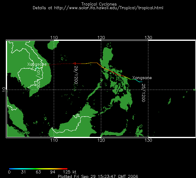
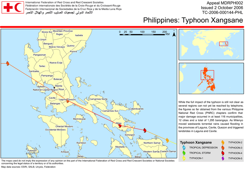
Typhoon Xangsane initially developed in the Philippine Sea on the 25th, crossing the Philippines as a typhoon on the 27th-28th with maximum sustained winds near 230 km/hr (125 knots or 145 mph). Xangsane was blamed for 110 deaths in the Philippines, caused 88 injuries, and knocked out power to more than half of the main island of Luzon. In Manila, the stock exchange, currency market, schools and government offices were temporarily closed as the typhoon was characterized as the worst to hit the city in over 35 years (Reuters). The typhoon made a final landfall in central Vietnam near Danang on October 1 with maximum sustained winds near 165 km/hr (90 knots or 105 mph). In Vietnam, there were 68 deaths and nearly 320,000 homes were destroyed or submerged (Reuters). |
Typhoon Xangsane
|

Tropical Cyclone 05B
|
Tropical Cyclone 05B developed in the Bay of Bengal on the 28th and moved inland near Brahampur, India the next day with maximum sustained winds near 65 km/hr (35 knots or 40 mph). Locally heavy rainfall affected the eastern states of India.
|

No reports of significant extratropical cyclones were received during September 2006 |

No reports of severe winter weather were received during September 2006 |
For all climate questions other than questions concerning this report,
please contact the National Climatic Data Center's Climate Services
Division:
- Climate Services Division
NOAA/National Climatic Data Center
151 Patton Avenue, Room 120
Asheville, NC 28801-5001
fax: 828-271-4876
phone: 828-271-4800
email: ncdc.orders@noaa.gov
|
For further information on the historical climate perspective presented in this report, contact:
- Scott Stephens
NOAA/National Climatic Data Center
151 Patton Avenue
Asheville, NC 28801-5001
fax: 828-271-4328
email: Scott.Stephens@noaa.gov
|
|


