Global Analysis / Global Hazards / United States / U.S.
Drought / Extremes
Use these links to access detailed analyses of Global and U.S. data.

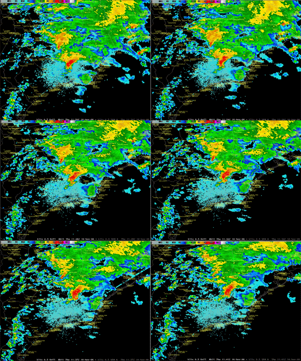
NC Tornado
|
Global Hazards And Significant Events
November 2006
In the United States, a thunderstorm produced a deadly tornado in southeastern North Carolina on November 16, 2006. Additional information can be found below.
|
 Drought & Heat | Flooding | Storms | Tropical Cyclones | Extratropical Cyclones | Severe Winter Weather


Across the United States, significant drought affected areas of the Plains and Rocky Mountains. Extreme drought was also concentrated in northern areas of Minnesota, parts of Wyoming and Nebraska, as well as sections of Texas and Oklahoma. |
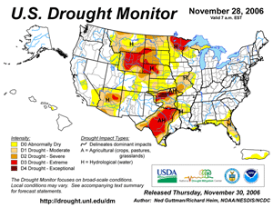
U.S. Drought Monitor
|
In China, extreme drought encompassed much of east-central China during mid-November. Water levels along the upper reaches of the Yellow River, China's second longest river, dropped to a historic low early in the month (Reuters/Xinhua). |
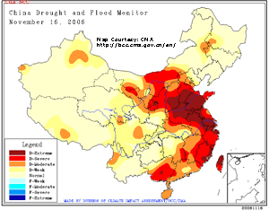
China Drought Map
|


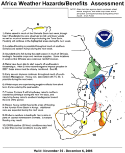
Africa Hazards/Benefits Assessment
|
Flooding in Kenya claimed 47 lives since October 25, 2006. Additional flooding continued farther to the north in the Jubba and Shabelle River basins in Somalia and Ethiopia (AFP). Flooding in neighboring Ethiopia was blamed for 116 deaths and the displacement of more than 300,000 people (AFP).
|
Heavy rainfall in the U.S. Pacific Northwest brought flooding to sections of Washington and Oregon, prompting evacuations and resulting in at least three deaths (Associated Press). A NOAA/U.S. Climate Reference Network site in the Olympic National Park recorded 640 mm (25.21 inches) from November 2-6. Heavy snowfall in the mountains during the 12th-13th prompted the closure of two mountain passes east of Mount Rainier until spring due to the threat of avalanches. This was the earliest such closure for one of the passes in 12 years (Associated Press). |
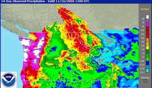
U.S. Northwest Precipitation
|
In northern Iraq, flash floods caused by torrential rain killed 18 people and injured 20 on the 5th-6th. The flooding occurred in Irbil province, destroying nine bridges and several houses (Associated Press).
|
In western Afghanistan, heavy rainfall during November 16-20 produced flash flooding that caused 120 deaths in the Badghis, Farah and Uruzgan provinces (Associated Press).
|
In Portugal, heavy rainfall produced flooding in central and southern parts of the country during the first week of November. While there were no fatalities, an undetermined number of sheep and other farm animals drowned in the floodwaters (AFP).
|
In Sri Lanka, heavy seasonal rainfall generated flooding and landslides that caused 45 deaths during November. It was the worst natural disaster in Sri Lanka since the deadly tsunami in December 2004 (AFP).
|
In Panama, heavy rainfall during the last week of November produced flooding that killed at least eight people. More than 200 houses were destroyed with nearly 700 others receiving damage (Associated Press).
|


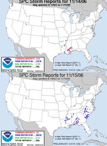
U.S. Severe Reports
|
A strong storm system progressing through the eastern United States produced severe thunderstorms and tornadoes across portions of the Deep South and Southeast during the 14th-16th. Strong winds flattened a skating rink in Montgomery, Alabama on the 15th where more than 30 preschoolers were playing. Two children suffered injuries but there were no fatalities. An F-3 tornado ripped through Riegelwood, NC on the 16th causing eight deaths and twenty injuries (CNN).
|
In Japan, thunderstorms associated with a frontal system spawned a tornado on Hokkaido in the northern town of Saroma on the 7th. It was the deadliest tornado on record in Japan with nine deaths and 25 injuries, with the previous record occurring in September 2006 when there were three deaths on the southern island of Kyushu (BBC News/Associated Press). |
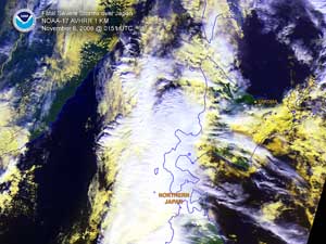
Japan Tornado
|


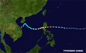
Typhoon Chebi
|
Typhoon Chebi developed in the Philippine Sea as a depression on the 9th, reaching typhoon intensity by the next day. Chebi crossed Luzon island on the 11th with maximum sustained winds near 195 km/hr (105 knots or 120 mph). Chebi affected the same region of the Philippines as Typhoon Cimaron just two weeks prior.
|
Typhoon Durian developed in the western Pacific Ocean on the 25th, reaching typhoon status by the 28th. Durian struck the northern Philippines on the 30th, passing south of Manila, with maximum sustained winds near 230 km/hr (125 knots or 145 mph). There were at least 406 fatalities in the Philippines, primarily caused by mudslides from torrential rainfall (International Herald Tribune). |
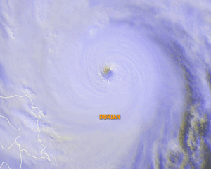
Typhoon Durian
|


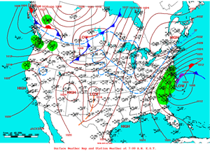
U.S. Weather Map For November 22
|
A strong extratropical cyclone developed off the southeast coast of the United States during November 21-22, producing a variety of weather along the Southeast and Mid-Atlantic coasts. Heavy rain and winds lashed the coastline from South Carolina northward through Virginia, while the earliest snowfall on record fell at both Charleston, SC and Savannah, GA. Snow flurries were reported as far south as central Florida on the 21st. Farther north, winds gusting over 115 km/hr (70 mph) were reported along the North Carolina coast, where significant coastal flooding and beach erosion was observed (Virginian-Pilot).
|


Heavy snowfall blanketed areas of the U.S. Pacific Northwest during late-November. New snowfall accumulations of up to two feet (60 cm) fell in the Cascades of Washington and Oregon, while light snow fell each day during the 26th-29th in the Seattle area. Additionally, it was the wettest month on record in Seattle with 396 mm (15.59") of rainfall, or the wettest month in 115 years of record-keeping. |
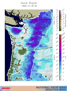
Pacific Northwest Snow Cover
|

For all climate questions other than questions concerning this report,
please contact the National Climatic Data Center's Climate Services
Division:
- Climate Services Division
NOAA/National Climatic Data Center
151 Patton Avenue, Room 120
Asheville, NC 28801-5001
fax: 828-271-4876
phone: 828-271-4800
email: ncdc.orders@noaa.gov
|

For further information on the historical climate perspective presented in this report, contact:
- Scott Stephens
NOAA/National Climatic Data Center
151 Patton Avenue
Asheville, NC 28801-5001
fax: 828-271-4328
email: Scott.Stephens@noaa.gov
|
|


